


Getting to and from Public Transport
NZ Public Transport Design Guidance – Phase 1
<AUTHOR>
16 MARCH 2021
13
 Copyright information
Copyright ©. This copyright work is licensed under the Creative Commons Attribution 4.0 International licence. In
essence, you are free to copy, distribute and adapt the work, as long as you attribute the work to Waka Kotahi NZ
Transport Agency and abide by the other licence terms. To view a copy of this licence, visit
http://creativecommons.org/licenses/by/4.0/.
Disclaimer
Waka Kotahi NZ Transport Agency has endeavoured to ensure material in this document is technical y accurate
and reflects legal requirements. However, the document does not override governing legislation. Waka Kotahi NZ
Transport Agency does not accept liability for any consequences arising from the use of this document. If the user
of this document is unsure whether the material is correct, they should refer directly to the relevant legislation and
contact Waka Kotahi NZ Transport Agency.
More information
Waka Kotahi NZ Transport Agency
Published [month and year]
ISBN [number]
If you have further queries, call our contact centre on 0800 699 000 or write to us:
Waka Kotahi NZ Transport Agency
Private Bag 6995
Wel ington 6141
This document is available on the Waka Kotahi NZ Transport Agency website at
http://www.nzta.govt.nz
link to page 4 link to page 4 link to page 5 link to page 6 link to page 6 link to page 6 link to page 7 link to page 7 link to page 8 link to page 11 link to page 12 link to page 17 link to page 18 link to page 18 link to page 19 link to page 21 link to page 23 link to page 24
 Contents
Overview: Getting to and from public transport ....................................................................... 4
The importance of getting to and from the stop .......................................................................... 4
Contents
Overview: Getting to and from public transport ....................................................................... 4
The importance of getting to and from the stop .......................................................................... 4
Whose role is it to consider getting to and from the stop? .......................................................... 5
Understanding customers and their journey choices .................................................................. 6
Planning for getting to and from the stop .................................................................................. 6
Public transport network considerations ..................................................................................... 6
Safety getting to and from the stop ............................................................................................. 7
Public transport access hierarchy ............................................................................................... 7
Planning for Walking ................................................................................................................... 8
Planning for Cycling & Micromobility......................................................................................... 11
Planning for fixed schedule and on-demand public transport ................................................... 12
Planning for motor vehicle connections to public transport ...................................................... 17
Infrastructure to support getting to and from the stop .......................................................... 18
Street environment considerations for walking ......................................................................... 18
Street environment considerations for cycling and micromobility ............................................. 19
Infrastructure for fixed schedule and on-demand public transport ........................................... 21
Infrastructure for motor vehicle connections to public transport ............................................... 23
Improving connections for getting to and from the stop ....................................................... 24
OVERVIEW: GETTING TO AND FROM PUBLIC
TRANSPORT
The importance of getting to and from the stop
Getting to and from public transport, or the ‘first and last mile’, is integral to every public
transport journey. Al passengers must make their way from their origin to a public transport stop
to board their public transport service, then make their way from the public transport stop where
they alight to their final destination. Whilst often termed the ‘first and last mile’ the actual length
of these trips can range from less than 100m to many kilometres.
First and last mile connections are critical to a viable and enjoyable public transport journey
experience. Key issues relating to the quality and ease of access to and from a public transport
stop include:
• The effective distance between the origin/ destination and the public transport station or
stop which largely determines whether passengers are able to walk or cycle or if they
must use a motorised mode to access public transport
• The level of comfort and extent of universal access along the connecting route – even
short distances may be unattractive or inaccessible for non-motorised modes if they
involve long or convoluted road crossings, extensive exposure to inclement weather or
lack of appropriate infrastructure
• The availability and attractiveness of motorised access mode options including taxi/
rideshare or feeder bus services, as well as facilities for kiss & ride or park & ride
• A person’s level of perceived or actual safety and security accessing public transport.
It is important that those involved in public transport planning consider the whole of the
passengers' journey. When planning for public transport journeys the following questions should
be considered:
• How will people get to and from their public transport services?
• Is the whole journey accessible for all people?
• Is the whole journey safe?
• Is the whole journey attractive, convenient, relatively seamless, and intuitive?
• Is the whole journey affordable?
WAKA KOTAHI NZ TRANSPORT AGENCY
GETTING TO AND FROM PUBLIC TRANSPORT //
4
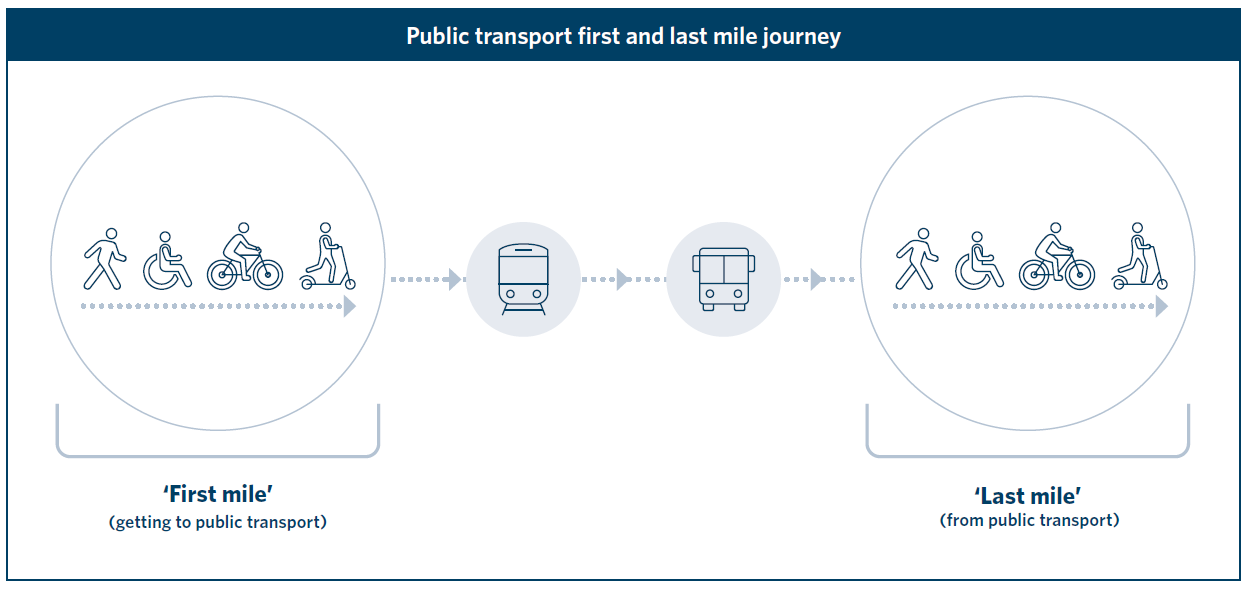 Figure 1: First and last mile as parts of a journey involving public transport.
Whose role is it to consider getting to and from the stop?
Figure 1: First and last mile as parts of a journey involving public transport.
Whose role is it to consider getting to and from the stop?
Planning for a whole-of-journey perspective often involves cross-organisation collaboration with
one organisation providing the public transport service and different organisations responsible for
infrastructure related to different access modes or routes to and from the station. Sometimes
planning for the whole journey can involve other organisations to ensure seamless connections to
public transport stops, interchanges, and the places that people want to get to and from. Public
sector organisations often collaborate with a range of other organisations to facilitate better
connections to and from public transport including:
• private companies that own and operate shopping malls or precincts
• education facilities with large campuses, such as schools and tertiary institutes
• large health services such as hospitals
• community facilities such as sports grounds and libraries
• housing/commercial developers.
The importance of getting to and from the public transport stops is even recognised in the way
that public transport is funded. Waka Kotahi NZ Transport Agency funding activity class WC531:
Public Transport Infrastructure and Renewals identifies ‘pedestrian and cycle access to public
transport services’ as a qualifying activity for funding as described in the Waka Kotahi Planning
and Investment Knowledge Base.
https://www.nzta.govt.nz/planning-and-investment/planning-and-investment-knowledge-
base/activity-classes-and-work-categories/public-transport/wc-531-public-transport-
infrastructure-improvements-and-major-renewals/.
Th
e New Zealand National Policy Statement on Urban Development has recently emphasised the
importance of increasing the density and mix of land uses around public transport stops,
particularly major rapid transport stops and stations. This is intended both to increase housing
supply and help address affordability challenges as well as to provide a larger base of potential
public transport customers within a short walk of high-quality public transport nodes.
WAKA KOTAHI NZ TRANSPORT AGENCY
GETTING TO AND FROM PUBLIC TRANSPORT //
5
New Zealand National Policy Statement on Urban Development 2020:
https://www.mfe.govt.nz/publications/towns-and-cities/national-policy-statement-urban-
development-2020
Understanding customers and their journey choices
There are many different types of public transport customers all with differing levels of
understanding of, and familiarity with the network, ranging from regular commuters to infrequent
users and unfamiliar users and visitors. Within these groups are customers with unique
requirements including the potential need for mobility or other assistance.
Despite these variables, most customers wil at some point undertake pre-journey planning to seek
out information about the public transport service before making their journey. Customers wil
generally wish to find out about the public transport route, timetables, ticketing and means of
getting to and from the public transport service. Even frequent customers may regularly undertake
pre-journey planning in the form of checking real time information including public transport vehicle
location, or even public transport vehicle occupancy (crowding) levels. The sources of information
available to customers include:
• Online sources
• Contact centre
• Printed material
• Asking someone (friends, family or others) who use the service regularly
Pre-journey planning is especially important for people unfamiliar with the public transport service
(new users) and people with disabilities. New users and people with accessibility requirements
need to be confident that they can efficiently and safely complete their public transport journey.
This is because for some people, particularly new users, making a public transport journey for the
first time may seem daunting.
Providing a richer set of information and data in journey planning tools can help customers to make
more informed travel decisions, information could include:
• The accessibility status of stops, vehicles and interchanges including location of ramps and
lifts, location of priority parking etc
• Showing specific footpath and pedestrian crossing facilities along the access route to guide
the user to the most direct route with the most appropriate facilities
• Live service disruptions (road closures, on time reliability, stop closures) which helps
customers to adjust their travel plans accordingly
• Stop and station security features (e.g. CCTV) and staffing times which supports user
comfort and confidence in using public transport
• Showing any cycle facilities along the access route to highlight where options exist for
cycling to provide an attractive and safe access option to/ from public transport
PLANNING FOR GETTING TO AND FROM THE
STOP
Public transport network considerations
Planning for getting to and from the stop should be undertaken alongside planning for the
locations of public transport stops and interchanges as part of wider land use and spatial
planning. When well-designed, public transport stops and routes provide for both efficient
journeys for the customer and an efficient network for the network operator and contract
manager/ funder.
<insert link to bus stop spacing section of the bus stop design topic>,
WAKA KOTAHI NZ TRANSPORT AGENCY
GETTING TO AND FROM PUBLIC TRANSPORT //
6
Where walking, cycling and micromobility access is safe, simple and intuitive for all ages and
abilities, the effective catchment area for public transport stops increases and in some cases bus
stops can be spaced further apart. This can lead to faster, more reliable and more efficient bus
services, with less travel time variability for all passengers.
Safety getting to and from the stop
While travelling by public transport is typically safer than other motorised modes, getting to and
from a stop or station can represent the highest risk component of the journey (see research
report in ‘Further Resources’ box below for more information). People walking and riding bicycles
are particularly vulnerable to being hit and injured by motor vehicle traffic.
Planning for safe routes to and from stops is a vital component of public transport planning. Road
safety considerations are particularly important to promote walking and cycling as healthy and
efficient modes while keeping public transport patrons safe throughout their whole journey.
Safety also includes peoples’ perceptions of being safe from traffic, as well as from harm or injury.
Planning for personal security and perceptions of safety on first and last mile trips is vital, the
importance cannot be overstated.
Further Resources
https://www.nzta.govt.nz/assets/resources/research/reports/581/581-the-role-public-transport-
can-play-in-safer-journeys.pdf
For further guidance related to stop spacing refer to <Bus Stop Design>
• <Link to route planning in Cycle Network guidance>
• <Link to Safety for Walking in Pedestrian Network guidance>
Public transport access hierarchy
When planning for getting to and from public transport, transport authorities may develop a
hierarchy to describe the relative level of priority that should be given to different access modes.
Whilst in practice, the specific priorities for each site or stop may differ, with multiple modes often
being catered for, the key considerations used in determining a more widely applicable hierarchy
would include:
• Efficiency – prioritising modes that are spatial y efficient, delivering the greatest number of
potential customers with the least ‘footprint’ or cost
• Equity and economy – that is prioritising modes that al or most people have access to with
little or no cost outlay
• Health and safety – that is prioritising modes that deliver the best health outcomes and
prioritising the safety of the most vulnerable users where there are conflicts between the
needs of different modes
As such, public transport access hierarchies always prioritise people over vehicles with walking the
highest priority and park and ride the lowest priority overall. Figure 2 below shows the key features
of a typical station access hierarchy.
WAKA KOTAHI NZ TRANSPORT AGENCY
GETTING TO AND FROM PUBLIC TRANSPORT //
7
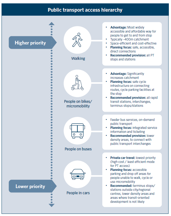 Figure 2: Mode provision hierarchy for getting to and from public transport and quick tips
Planning for Walking
Figure 2: Mode provision hierarchy for getting to and from public transport and quick tips
Planning for Walking
Walking is one of the most practical, affordable, and widely accessible ways for people to
undertake the first and last mile of journeys involving public transport.
Walking is the most common way for New Zealanders to get to and from a public transport stop.
Surveys in the Wellington Region have shown that 85% of trips to a public transport stop, and 92%
of trips from the stop to the destination, were made as a pedestrian.
WAKA KOTAHI NZ TRANSPORT AGENCY
GETTING TO AND FROM PUBLIC TRANSPORT //
8
(https://www.gw.govt.nz/assets/Transport/Regional-transport/Regional-Transport-
Analysis/StateofWalkingReportWellingtonRegion2001-2015.pdf).
Walking is also the most space-efficient mode, meaning that more people can travel on a footpath
per square metre than typically travel in a road lane. Walking access, including safe and
convenient road crossings, should be built into new land developments, redevelopments, or
retrofitted if there are deficiencies in the existing environment. (see Checklist: Improving
connections for getting to and from the stop). This wil help ensure that people in the whole area
around a public transport stop or station feel that they can access and use the facility.
The most powerful tool planners can use to promote the use of public transport is to enable
compact urban form and permeable street designs (lanes, paths and road crossings) that provide
access for walking and cycling).
How far people are willing to walk to/from public transport can be affected by:
• The level of service of walking facilities including factors such as pedestrian delay,
amenity, directness and safety/security
• The level of service of the public transport, with higher frequency, faster services typically
attracting customers from a wider catchment than slower lower frequency services
The below table provides a general guide for the distance which customers may be willing to walk
to access different types of public transport services. In practice some customers may be willing
to walk shorter distances whilst other customers are willing to walk longer distances. Therefore,
walking catchments do not have fixed boundaries but rather the percentage of people who walk
to and from public transport stops tends to drop off significantly beyond the distances shown in
Table 1.
Table 1: General walking catchments to stops with different levels of public transport service (Source: South-
East Queensland household travel survey)
Walking catchment
For
≤400m or 5min walk
Low frequency public transport stops
≤800m or 10min walk
High frequency public transport stops (a service at least
every 15min)
≤1200m or 15min walk
High frequency and rapid public transport stops or stations
Public transport catchment sizes may also increase in areas that are particularly pedestrian-
oriented as people are willing to walk further where it is pleasant to do so, and when the
environment at the stop or station is also pleasant. This is supported by research which shows
that people remember the walking legs of their public transport journeys more vividly than the in-
vehicle legs and perceptions of walking time are longer for less pleasant walking environments
(refer Hil nhütter 2019, referenced at bottom of page).
Urban design and street layouts should support legible and intuitive access to public transport to
the greatest extent possible. Planning for wayfinding is important as a network-wide solution to
promote the uptake of public transport, particularly for people who are new to an area, or
visiting. It can also highlight public transport as a possible mode of travel.
Using wayfinding to support getting to and from the stop can include digital real-time signage in
popular trip destinations such as shopping centres and public libraries.
WAKA KOTAHI NZ TRANSPORT AGENCY
GETTING TO AND FROM PUBLIC TRANSPORT //
9
• Guidance on walkability and wayfinding for walking is provided in the Pedestrian Network
Guide.
• <Insert links to PNG sections on Walkability and Wayfinding>
Guidance on spacing bus stops is offered in the bus stop design topic but it is worth noting that
there are important trade-offs between trying to ensure stops are close and convenient for public
transport passengers to walk to but spaced far enough apart to improve public transport travel
time and reliability to create an attractive and efficient service.
• <Insert link to PT Network Planning / Bus Stop Design topics>
• <insert link to walkability in Pedestrian Network Guide>
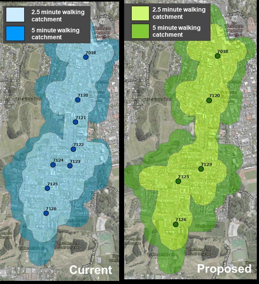
A Wel ington case study shows the current walking catchment of a bus service (current in Figure
2), and how it could still be well-serviced by more strategic placement of fewer bus stops, thereby
reducing public transport travel times (proposed in Figure 2).
Figure 0-1: In this case study of Berhampore, Wellington a similar walking catchment can be served
with less stops by strategic placement of stops, reducing total travel times on public transport
(Images by Wellington City Council)
WAKA KOTAHI NZ TRANSPORT AGENCY
GETTING TO AND FROM PUBLIC TRANSPORT //
10
The analysis above found that consolidating stops with an aim of approximately 1 stop per 400m
could result in increased efficiency of the bus service with very little impact on the effective 5-
minute walk catchments. As such any disbenefits resulting from increased walk distances by some
customers was more than outweighed by in vehicle travel time and reliability benefits as
confirmed through economic analysis.
References and additional resources
Hil nhütter, H. (2019). Walking for Public Transport. Proceedings of the Walk21 Conference, Rotterdam.
Current published version here:
https://www.vegvesen.no/_attachment/1592640/binary/1143108?fast_title=Walking+for+Public+Transport.
pdf
Queensland Government (2015). ‘Chapter 3: Supporting access infrastructure’. Available online
a
t: https://www.publications.qld.gov.au/dataset/public-transport-infrastructure-
manual/resource/b90e1d85-1d10-4804-84ed-ddd20f257f7f
Planning for Cycling & Micromobility
The catchment area for public transport stops and stations can be significantly extended through
the use of bicycles or micromobility devices. This option is likely to be more attractive for longer
public transport journeys because for shorter overall trip length cyclists may simply choose to ride
the whole way.
Table 2 provides a typical practice guide about potential catchment sizes associated with cycling
and powered micromobility.
Table 2 Riding catchments and service provision (based on Department of Transport and Main Roads 2016)
Riding catchment
For
≤2.5km or 10min riding
All public transport stops or stations with convenient end-of-
trip access to stop/station, amenities and attractive public
transport services
≤5km or 20min riding
Premium public transport stops and high passenger volume
stations with high-quality, secure end-of-trip facilities
Up to 15km
Limited uptake, only for high passenger volume public
transport stations where there is a long-distance commute
to the nearest activity centre; important for ‘end of line’
services, particularly train stations, and some e-bike access
For additional information on riding catchments and more detailed guidance refer to the
Queensland Public Transport Infrastructure Manual (2015), Chapter 3:
https://www.publications.qld.gov.au/dataset/public-transport-infrastructure-
manual/resource/b90e1d85-1d10-4804-84ed-ddd20f257f7f
To plan for cycling and micromobility access to public transport, practitioners should consider the
following:
• Routes to/ from ‘premium’ high frequency stops/stations are a high priority due to
potential for mode shift: plan for infrastructure improvements to fill the gaps in on-road
WAKA KOTAHI NZ TRANSPORT AGENCY
GETTING TO AND FROM PUBLIC TRANSPORT //
11
and off-cycling road routes, and stop/station infrastructure including protected cycle
parking or storage (particularly where bicycles are not permitted on buses/trains)
• Routes to/ from stops/stations in low density areas that connect to long PT journeys: plan
for infrastructure improvements to fill the gaps in on-road and off-road routes, and
provide secure cycle parking
• Consider personal amenities such as changing rooms at stations with high rates or
potential rates of cycling, please refer to the public transport interchange chapter.
• The ability to take a bicycle or other micromobility device onto a bus or train can help
encourage journeys using public transport. See the Requirements for Urban Buses.
Planning for cycling and micromobility should identify appropriate locations for infrastructure
interventions based on the role of each street for movement and place. It should also include
wayfinding for cycling in local streets to attract new trips by bicycle. See the City Network
Guidance.
Figure 0-2 Example of cycle parking facilities, Rangiora (Credit: Simon Hart)
• <link to PT interchange topic>
• Requirements on Urban Buses for space al ocation for mobility devices on buses
• <Insert link to wayfinding in Cycle Network Guidance>
Planning for fixed schedule and on-demand public transport
Rapid transit stations (heavy rail, light rail or busway) tend to have wide station spacing and
therefore some customers wishing to access services from these stations may live outside of a
comfortable walking or cycling distance. Therefore, it is more common for customers accessing
rapid transit station to use motorised modes compared to customers accessing their local public
transport stops. Feeder bus services provide an important means of accessing the rapid transit
WAKA KOTAHI NZ TRANSPORT AGENCY
GETTING TO AND FROM PUBLIC TRANSPORT //
12
network, this section discusses ways to plan for seamless connections between public transport
services.
Fixed schedule public transport services
Fixed schedule public transport services have trips which depart at the same time and follow the
same route each day. Fixed schedule services are the most common form of public transport in
New Zealand.
There are three types of connections between fixed schedule public transport services which are:
• Pulse connection is where multiple public transport routes are coordinated so that vehicles
arrive at a station at regular times on the hour (general y a train station or town centre) so
that passengers can transfer between routes.
• Timed connection is where the feeder public transport service is scheduled to arrive at the
station before the connecting service with passengers waiting in between services
(general y 5 to 10 minutes).
• Frequent connection is where two high frequency public transport routes (generally every
10 minutes or better) cross paths and passengers transfer between. For frequent
connections the timetables are not coordinated because the high frequency means that
there should only ever be a short wait between services.
Diagram showing the principle of pulse timetable operations (Nielsen, G. HiTrans Best practice guide to Public
Transport – Part 2 Planning the networks)
For pulse and timed connections, the reliability of the connecting services is a critical consideration
(especial y if the frequency of the services is low). That is, if the services are unreliable then it is
difficult to ensure a reliable connection between services without having excessively long wait
times for passengers. The techniques available to practitioners to addressing unreliable connecting
services include:
• Implementing public transport priority if the cause of the unreliability is delay caused by
traffic congestion. The Public Transport Priority and Optimisation chapter provides
guidance on selecting appropriate priority measures.
• Reducing delays at bus stops through measures such as all door boarding, faster ticketing
and bus stop consolidation. Further guidance on reducing delays at bus stops can be
found in the Bus Stop Design chapter.
• Designing shorter public transport routes if the trip distance is excessively long. This
approach needs to be balanced against network efficiency and avoiding unnecessary
transfers.
• Enabling connecting services to wait at the transfer point for a period of time after the
scheduled departure if there is a delay to the service. Having connecting services wait
needs to be balanced against delays for other passengers along the route.
Another consideration for timed connections is the compatibility of the services headways between
connecting services. Time connections work best if the connecting services have the same or a
dividable headway for example a train service with a 30min headway would connect best with a
WAKA KOTAHI NZ TRANSPORT AGENCY
GETTING TO AND FROM PUBLIC TRANSPORT //
13
bus service with a 60, 30 or 15min headway. A connecting service with an incompatible headway
(a bus service every 20min using the same example) would result in connection times that are
either too long or too short.
WAKA KOTAHI NZ TRANSPORT AGENCY
GETTING TO AND FROM PUBLIC TRANSPORT //
14


 Compatible service headways
0
5
Compatible service headways
0
5
Feeder service
Connecting
service departure
arrival times
times
35
30
30min feeder and connecting services results in two optimal connections
Incompatible service headway
0
5
Feeder service
Connecting
arrival times
45
service departure
times
25
30
30min feeder and 20min connecting services results in one optimal connection, one long connection and one
missed connection
On-demand public transport services
On-demand public transport services have flexible routes and timetables which change based on
the location and destinations of passengers who book a trip. Some on-demand public transport
services require passengers to walk to fixed stop locations (which may or may not have bus stop
infrastructure) whilst other pick passengers up from their driveways. For some on-demand services
passengers are limited to set destinations with other on-demand services dropping passengers at
any destination within a fixed area. On-demand public transport services are a new addition to the
public transport system in New Zealand with trial services having been untaken in Timaru and
Devonport, Auckland.
WAKA KOTAHI NZ TRANSPORT AGENCY
GETTING TO AND FROM PUBLIC TRANSPORT //
15
On-demand public transport services can provide an important connection to the wider public
transport network. Compared to fixed schedule services, on-demand services have the following
advantages and disadvantages:
Advantages
Disadvantages
• Provides a transport option for areas
• Smal er vehicles are able to carry less
underserved by existing public transport
passengers which may be a limitation at
options, these areas may be inefficient to
peak times
serve by traditional public transport
• Less certain route and arrival time as
• Can provide a door to door service which
timetable and route is responsive to other
is particularly important for passengers
passengers
with limited mobility
• Lack of bus stops for some on-demand
• More flexible departure times which is not
services reduces awareness of the
limited by a fixed timetable
service, this can be mitigated through
greater marketing
• Generally high operation cost per
passenger
Depending on the transport options, land use characteristics and customer preferences some
areas may be more efficient to serve with on-demand public transport whilst other would suit fixed
schedule public transport. A public transport network can be made of both on-demand and fixed
route services which work in combination to maximise access to public transport. In this approach
fixed schedule services would provide direct connections between main destinations and on-
demand services would provide coverage for low density outer areas.
Network design approach incorporating fixed schedule and on-demand services (adapted from Nielsen, G.
HiTrans Best practice guide to Public Transport – Part 2 Planning the networks)
WAKA KOTAHI NZ TRANSPORT AGENCY
GETTING TO AND FROM PUBLIC TRANSPORT //
16
Planning for motor vehicle connections to public transport
The access hierarchy <insert link back to the access hierarchy in this chapter> emphasises that
walking, cycling, micromobility and, to a lesser degree, feeder services are the most spatially and
economically efficient ways to get people to and from public transport. However, there is a case
for providing access for other motorised trips to and from the stop or station in one of two ways:
• Providing drop-off/pick up access for private or shared passenger vehicles in a way that
does not compromise access for other modes. This may be particularly relevant in areas
where feeder or even on-demand services are unviable.
• Providing parking spaces to store private vehicles at stations. Whilst this is a relatively
high cost, low value use of land it may be appropriate where demand for alternate land
uses is currently low, particularly if it is designed as an interim measure that retains the
potential for subsequent re-purposing.
Drop-off areas
Short stay vehicle access for drop-offs represents an important method for accessing some public
transport stations. They extend the reach of public transport for people who choose not to walk,
cycle, or use micromobility devices and do not have access to feeder services. They also provide
access for people who cannot walk far, and therefore cannot otherwise get to and from the stop
easily.
“Drop-off” comes in two primary forms: (1) “kiss and ride” (that is, drop-off areas where drivers
stop for just a few seconds) and (2) on-demand services, such as taxis and ride-share. Drop-off
facilities can help extend the reach of public transport without the high costs associated with
providing all day parking due to higher turnover of each vehicle space.
The growing demand for app-based ride-hailing may increase pressure on drop off areas and
surrounding kerb space. Drop-off facilities are most suited to premium public transport stations
with large catchments that are not entirely covered by feeder public transport services. They are
less suited to busy town and regional centre stations where they would displace other land uses
or create a traffic barrier between the station and other destinations. They can, however, be
accommodated with proactive urban design and streetscape treatments to minimise a potential
separation of services.
Park and Ride
Provision of park and ride facilities to allow customers to cover the first and last mile (at one end
of their trip) in their own vehicle is generally considered the least effective and most expensive
option for transport agencies. Some of the key drawbacks include:
• It can make other more efficient modes (such as walking, cycling and micromobility) less
attractive due to the presence of busy circulating roadways and lack of activation adjacent
to the station;
• In some locations park and ride may have limited benefit for attracting new public
transport patronage – many park and ride users would continue to use public transport
without the park and ride, but would have otherwise accessed the station with a different
mode;
• It is expensive to build and maintain;
• It may take up high-value land, removing the opportunity to increase land use density
around the transit stop which would potential y support higher patronage;
• It surrounds the station with a swathe of under-utilised space, which pushes active land
uses further away and may impact on feeder services
• It increases local traffic and may induce local congestion and create a traffic barrier
between the station and adjacent destinations; and
WAKA KOTAHI NZ TRANSPORT AGENCY
GETTING TO AND FROM PUBLIC TRANSPORT //
17
• It may exacerbate undesirable urban sprawl.
However, providing parking facilities can have benefits, namely:
• Extending the reach and catchment for public transport, particularly where that
catchment includes rural areas without feeder services;
• In some instances, increasing public transport patronage; and
• Reducing broader network congestion by replacing longer car journeys with public
transport journeys, locations.
INFRASTRUCTURE TO SUPPORT GETTING TO
AND FROM THE STOP
Street environment considerations for walking
Designing safe and convenient public transport facilities for pedestrians involves considering
safety, accessibility, directness, and amenity (or attractiveness) of the walking network.
The Pedestrian Network Guidance provides extensive and robust guidance on planning and
designing for walking. This section of the Getting to and From Public Transport guideline provides
a snapshot of some key considerations to get you started and is focussed on walking to and from
public transport specifically. However, links to the relevant sections of the Pedestrian Network
Guidance are also offered along the way.
Safety and accessibility for walking
Consideration for walking includes the presence and quality of pedestrian infrastructure, including
paths, crossings, and bridges. Traffic volumes and speeds are key considerations when it comes to
pedestrian safety. Movement and Place frameworks such as, for example, the One Network
Framework can help identify where infrastructure improvements may be most needed to
promote safe connections to public transport stops and stations.
Perceptions of safety while travelling to and from public transport can be a strong influencing
factor in peoples’ decision to use public transport. Crime Prevention Through Environmental
Design (CPTED) audits can help identify opportunities to enhance actual and perceived safety.
Safe and obvious walking routes that include step-free choices make the first and last mile
accessible to a broader range of people. These accessibility considerations are particularly
important for people who do not or cannot drive and are therefore more likely to rely on public
transport for their everyday participation.
• <Link to One Network Framework >
• <Link to CPTED detail within Pedestrian Network Guidance>
• <Link to principles of universal access for walking in Pedestrian Network Guide>
• <Link to Inclusive Access Case Study>
Directness and convenience for walking
Providing more direct connections to public transport will also increase the catchment area within
a 5-10min walk of the service. Minimising delay at pedestrian crossings is important, so providing
pedestrian priority wherever practical will make for more attractive walking connections to public
transport. It is also important that once a pedestrian arrives at a station, the access to the actual
platform or boarding area is direct rather than expecting people to take circuitous routes around
parking or other infrastructure.
WAKA KOTAHI NZ TRANSPORT AGENCY
GETTING TO AND FROM PUBLIC TRANSPORT //
18
• <Link to discussion of directness and lack of delay for walking in Pedestrian Network
Guide>
Amenity for walking
Increasing the attractiveness, or amenity value, of walking routes in the first and last mile is likely
to increase the overall number of people who walk to and from their public transport service. As
well as traffic and network considerations, amenity considerations, including lighting, planting,
shade/weather protection (including at major road crossings), and wayfinding information,
contribute to the pedestrian experience.
• <Link to Bridging the Gap urban design guide> <Link to CPTED Case Study>
Street environment considerations for cycling and micromobility
The reach of public transport is extended when people can cycle or use micromobility to get to
and from a stop. Designing connections for cycling and micromobility to and from public transport
requires consideration of safety, directness, and end of trip/interchange facilities.
Safety for cycling and micromobility
Street design that makes cycling and micromobility safe and attractive promotes good
connections for public transport journeys. As is the case for walking, low traffic volumes and low
speeds promote safer travel. High quality cycling infrastructure (i.e. separated from traffic) should
be provided where traffic volumes or speeds are high. Traffic calming could also be considered.
Considerations about whether or not cyclists and those using powered micromobility will be
comfortable using traffic lanes safely depends on the street context.
• Robust guidance on designing cycling infrastructure is available in the Cycling Network
Guidance:
https://www.nzta.govt.nz/walking-cycling-and-public-transport/cycling/cycling-standards-and-
guidance/cycling-network-guidance/.
Micromobility such as private and shared e-scooters, and shared mobility such as bicycle and e-
bike share, are emerging means for people to bridge the first/last mile gap and to extend the
reach of public transport. There is limited research on the extent to which micromobility is being
used as a first/last mile solution. However, the tools to encourage the safe use of non-powered
micromobility devices to access public transport are like those for walking, such as wider
footpaths and high-quality crossings, and cycling. Powered micromobility such as electric
scooters, are newer to New Zealand and are currently often operated on footpaths. Legislation is
being considered to support use of cycle lanes and cycleways which may be a more appropriate
location for those wanting to travel at speeds more compatible with cycling.
Charging points and secure storage may be beneficial at larger stations, particularly at ‘end of line’
stations. Where shared bikes or scooters are used, space should be provided outside the station
where they can be left without blocking footpaths. At stations with large numbers of people
arriving by walking or cycling and scootering, infrastructure should provide separation between
people moving at different speeds.
WAKA KOTAHI NZ TRANSPORT AGENCY
GETTING TO AND FROM PUBLIC TRANSPORT //
19
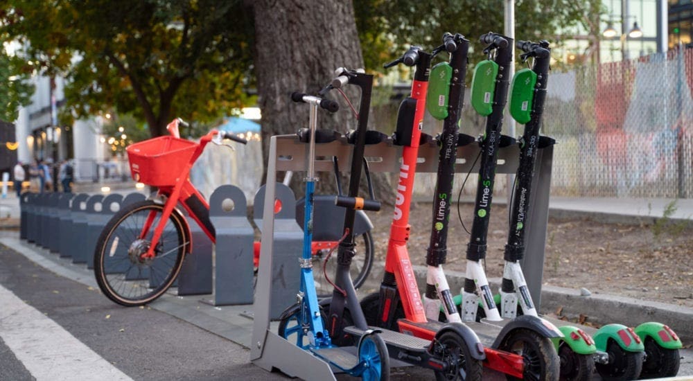 Figure 4 Example of cycle and e-scooter parking facilities (Source: Ground Control Systems)
Directness for cycling and micromobility
Figure 4 Example of cycle and e-scooter parking facilities (Source: Ground Control Systems)
Directness for cycling and micromobility
Permeable street networks allow for direct cycling and micromobility journeys. Permeability can
include off-road connections not available to cars and larger motor vehicles or protected mid-
block crossings across busy streets. Opportunities to provide cycling and micromobility
connections to make journeys more direct are presented in the Cycle Network Guidance.
• <Link to Cycle Network Guidance>
Stop and station infrastructure for first and last mile
The attractiveness and therefore use of cycling and micromobility to access public transport
increases if high quality end of trip facilities are provided at the stop or station. Such facilities may
include:
• Direct and prioritised access to the platform or boarding area from the street (namely,
avoiding the need for cyclists and micromobility riders to travel through a car parking
area);
• Secure storage and lockable parking for bicycles and scooters;
• Lockers for personal storage;
• Storage docking stations for shared bikes/scooters;
• Storage zones for dockless devices such as shared bikes/scooters;
• Charging facilities for e-bikes and powered micromobility;
• Bathrooms; and
• Bicycle / scooter repair stations.
The Interchanges section of the PTDG provides further guidance related to the end of trip
facilities, as does the Cycle Network Guidance.
• <Insert links to Interchanges chapter of PTDG and Bicycle parking chapter of CNG:
https://www.nzta.govt.nz/resources/cycle-parking-planning-and-design/
WAKA KOTAHI NZ TRANSPORT AGENCY
GETTING TO AND FROM PUBLIC TRANSPORT //
20
 Infrastructure for fixed schedule and on-demand public transport
For guidance on the design of interchanges to accommodate the needs of al users please refer to
the Interchanges Design Chapter. This section provides an overview of the design considerations
for enabling seamless transfers between public transport services.
Fixed schedule public transport services
As fixed schedule public transport services have a limited amount of time between services, it is
important to minimise the distance between transfer points. This can be achieved by prioritising
public transport access over other motor vehicle access when designing the interchange. Ideal y
connecting public transport services should be located immediately adjacent to the main station
platforms or adjacent to the main entrance to the station. If vehicle types are compatible (bus to
bus or bus to light rail connection), then connecting public transport services could use the same
platform.
Park n ride
Connecting
bus services
Train station
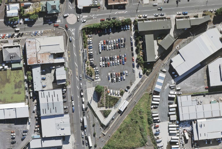
Example of interchange with poor connection between public transport services with bus services being
located further away from train station than park n ride. Onehunga Station, Auckland (Image source: LINZ,
NZTA, Eagle Technology)
WAKA KOTAHI NZ TRANSPORT AGENCY
GETTING TO AND FROM PUBLIC TRANSPORT //
21
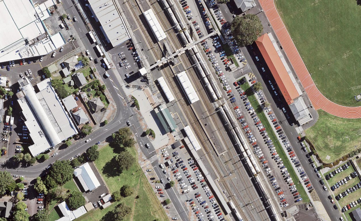
Train station
Connecting
bus services
Park n ride
Example of interchange with good connections between public transport services with bus services being
located outside main entrance to the station. Papakura Station, Auckland (Source: Auckland Council)
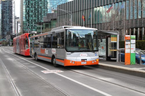
Example of bus and tram services sharing the same platform at Queens Bridge Street, Melbourne
(image source: Marcus Wong)
WAKA KOTAHI NZ TRANSPORT AGENCY
GETTING TO AND FROM PUBLIC TRANSPORT //
22
Other design considerations for enabling seamless transfers include:
• Locating connecting public transport services on the same side of the road which avoids
passengers having to cross traffic lanes
• Maximising directness of walking routes and providing visual links between transfer
points which makes it legible and intuitive for passengers to find their way between
services
• Providing step free routes between transfer points to enable universal access for all users
to the public transport system
• Having sufficient stop capacity to enable connecting vehicles to wait for a late running
service
• Providing shelter between transfer points if a walk between stops or platforms is
required
On-demand public transport services
The level of infrastructure required for on-demand public transport services at stations will
depend on frequency, vehicle size and various operational characteristics which affect dwell time.
The station infrastructure required for on-demand public transport could range from simply a
dedicated priority parking spot for a low volume small vehicle service to a length of kerb space for
a higher volume or medium to large vehicle operated service. Additional considerations for the
design of on-demand public transport infrastructure at interchanges includes:
• Providing an accessway layout that enables vehicles to safety turn around which is
separate from walking and cycling routes
• Encouraging the turnover of drop off spaces which could include parking time restrictions
• Pedestrian walking routes between the drop off area and the connecting public transport
services
• Weather protection, lighting and CCTV for passengers to wait safely and comfortably
Infrastructure for motor vehicle connections to public transport
Designing a Park and Ride
Considerations for the design of a park and ride facility include:
• Providing the most convenient facilities for people with the fewest alternatives, i.e.,
accessible parking spaces;
• Prioritising access to and through stations for people arriving by walking, cycling or
micromobility devices above those who park and ride.
• Prioritising relatively efficient and sustainable travel choices, such as spaces for carpooling
or charging for electric vehicles;
• Protecting feeder bus operations or rail replacement services from park and ride
congestion;
• Providing safe and secure access for people to walk from their cars to the bus or train
platforms, with good lighting and surveillance;
• Setting parking fees to optimise parking utilisation at close to 95% of capacity and
potentially splitting into functionality areas based on different periods of time/ costs
people would be interested on leaving their vehicles in;
• Setting at least a nominal parking fee from the outset and noting that it is subject to
review based on demand, can help to manage user expectations in advance of future
reviews of pricing levels; and
• Managing on-street parking demand with time restrictions and fees to discourage
spillover effects or to create incentives (e.g. around car-share, electric vehicles).
WAKA KOTAHI NZ TRANSPORT AGENCY
GETTING TO AND FROM PUBLIC TRANSPORT //
23
Monitoring the uptake of a park and ride can help with an overall public transport planning
approach to promote an effective and integrated public transport network.
Temporary Park and Rides
Recently in New Zealand there has been consideration about whether to implement temporary
park and rides at some newly developed railway stations. While this may help attract some
people to use the new railway stations, there is some risk that it wil be hard to remove in the
future and/or will create a precedent of parking provision at the station leading to pressure to
develop additional parking rather than eventual infill development.
It is recommended that temporary park and ride facilities be priced, at least to some degree,
which will enable demand management and increase the attractiveness of alternative modes for
access.
IMPROVING CONNECTIONS FOR GETTING TO
AND FROM THE STOP
Once public transport routes for first and last mile improvements have been identified, the
following checklists can be used to assess their quality. Deficiencies can then be addressed through
routine maintenance or capital improvements programmes.
The table can also be used proactively, to assess the appropriateness of new public transport stops
in relation to the local neighbourhood. While the interventions are listed in order of impact, the
most useful interventions depend on the local street and land use context.
More information about design for walking, cycling and micromobility, including advice on different
methods and tools than can be used for more detailed access assessments are provided in the
Pedestrian Network Guide and Cycling Network Guide.
WAKA KOTAHI NZ TRANSPORT AGENCY
GETTING TO AND FROM PUBLIC TRANSPORT //
24
Factors to consider
✓✗
Advice / Assessment Notes
t Are vehicle speeds and
If speeds are >30km/h and/or traffic volumes are
volumes low?
greater than 3,000 vehicles per day, consider traffic
impac
calming treatments and/or separated facilities for
walking, cycling, and micromobility
igher
H Are there safe and obvious
Are footpaths of high quality? Are ramps and
step-free routes?
alternative routes of a shallow gradient, well-
advertised, wel lit, and slip-resistant?
Are paths attractive and
Are there opportunities for off-road walking and
direct?
cycling connections / cut-throughs? Are footpaths
wide enough or are there opportunities to widen
them?
Are road crossings appropriate
Do people need to make circuitous routes to use
and on desire lines?
crossings? Are crossings where people actual y
cross? Are they safe? Is it the right type of
crossing? Are there missing crossings or do they
require further protection at signals or unacceptable
levels of delay? Check crash history and/or
Pedestrian Network Guidance for guidance on
crossing types etc.
Are streets and paths well-lit,
Wil people feel safe getting to and from the stop in
following CPTED principles?
the dark? Does the stop benefit from passive
surveil ance?
Are the feeder public transport
Investigate the causes of unreliability and
services reliable?
implement appropriate public transport priority
measures.
Are the feeder and connecting
Reallocate interchange space to bring feeder and
public transport services
connecting public transport services closer together
located a short walk from each
whilst also prioritising access for people walking
other (ideal y 20m or less)?
and people on bikes.
Are there access and parking
Are cycle and micromobility paths and facilities
facilities at the stop or station
prioritised above car park access? Are there secure
for people cycling or using
parking or storage, charging points, lockers, and
micromobility?
bathrooms? Note: provide cycle parking for a range
of users.
Are the connection times
Adjust the feeder or connecting public transport
to/from feeder public transport
service timetables to improve connection times
services optimal (not too short
or too long)?
Is there obvious wayfinding to
Is there signage for people unfamiliar with the
direct people to the stop or
area?
station?
Are there accessible parking
Is the stop or station accessible to someone who
and drop-off options at the
cannot walk far, or who needs to drive there or be
stop or station?
dropped off? Are feeder bus stops close to the
station?
t Are there street trees and
Are walking routes attractive, including in hot
ac planting?
weather, and with shelter from wind/rain?
imp
er Is there seating along walking
Are walking routes pleasant, encouraging a sense
Low routes?
of place?
WAKA KOTAHI NZ TRANSPORT AGENCY
GETTING TO AND FROM PUBLIC TRANSPORT //
25
Are cycle facilities free of glass
Are cycling and micromobility routes reliably
and debris?
smooth?
Is shared cycling/micromobility
Is there opportunity to provide or promote public or
(e.g. bikeshare or scooter
private cycle or micromobility options?
share) available?
Would park and ride facilities
Consideration at the end of high-frequency routes,
increase public transport
particularly bus and train stations at the ends of
patronage?
lines and where people travel a long way to their
destination
• <Pedestrian Network Guide>
• <Cycling Network Guide>.
WAKA KOTAHI NZ TRANSPORT AGENCY
GETTING TO AND FROM PUBLIC TRANSPORT //
26
Document Outline