
1
Notice of Meeting:
I hereby give notice that an ordinary Meeting of the Strategy and Policy Committee will be held on:
Date:
Tuesday 26 June 2018
Time:
10.00am
Meeting Room:
Council Chamber
Venue:
Waikato Regional Council, 401 Grey Street, Hamilton East
VRJ Payne
Chief Executive Officer
Strategy and Policy Committee
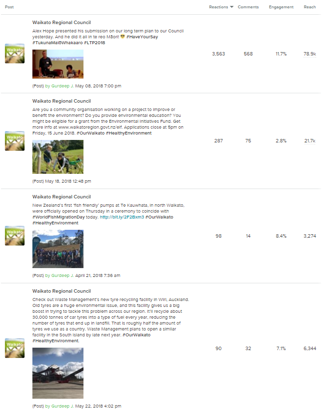
Agenda
Chair
Cr B Simcock
Deputy Chair
Cr T Mahuta
Members
Waikato Regional Council
Cr J Hayman
Cr J Hennebry
Cr K Hodge
Cr S Husband
Cr S Kneebone
Cr F Lichtwark
Cr A Livingston
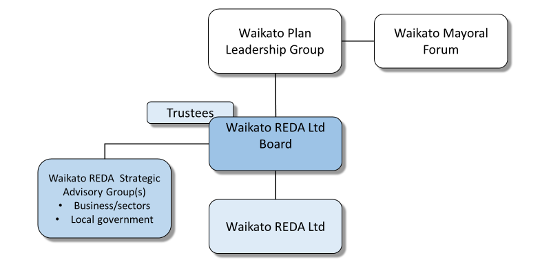
Cr T Mahuta
Cr D Minogue
Cr R Rimmington
Cr B Simcock
Cr H Vercoe
Cr K White
Cr B Quayle
Quorum
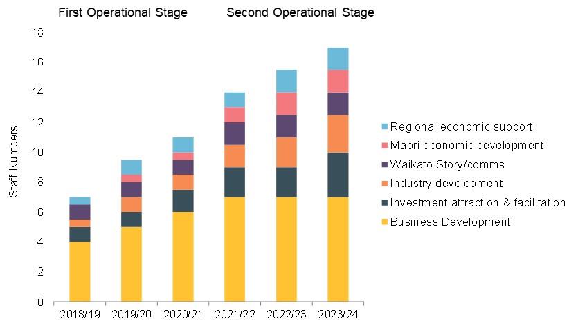
Eight members
Gavin Dawson
Telephone: 0800 800 401
Democracy Advisor
[email address]
Website: www.waikatoregion.govt.nz
Doc # 12653233
2
OBJECTIVE:
To set council’s strategic direction and policy responses, signal regional issues, respond to external
agency statutory planning processes via advocacy submissions, advise Council in respect of thought
leadership across matters of regional significance, establish strategic priorities for organisational
direction and policy setting.
SCOPE OF ACTIVITY:
1.
This committee will advise council on matters relating to their regional governance role, which
will include delegation to:
(a)
Develop council’s strategic direction and recommend policy responses.
(b)
Develop council’s position on regionally significant issues.
(c)
Provide guidance on regional governance matters, and receive regular information from
regional governance projects, such as the work that is being undertaken by the Waikato
Mayoral Forum work streams, which includes the development of the Regional Economic
Development Strategy and the Waikato Spatial Plan.
(d)
Prepare submissions in relation to central government, neighbouring regional council and
territorial authority policy documents, strategies and proposals to support alignment with
council’s strategic direction and policies.
2.
To maintain oversight of all council’s policy and plans to ensure alignment with strategy.
3.
To receive information that monitors the effectiveness of Council’s strategic influence in the
region and to review and recommend revision of Council’s position accordingly.
4.
To approve changes to corporate support and financial policies apart from matters that affect or
alter Council’s Annual or Long Term Plan.
5.
To approve Strategic Finance Policy.
6.
To approve Catchment Management and Regional Pest Management Policies, Plans and
Strategies.
CROSS BOUNDARY COLLABORATION:
1.
To foster cross boundary collaboration on issues where an inter‐regional response will create
policy or advocacy efficiencies.
2.
To be kept informed of emerging cross boundary issues and to provide guidance on Council’s
position.
3.
To provide guidance on cross boundary collaboration, and also receive updates and feedback.
4.
To provide strategic oversight for programmes related to Upper North Island direction, Auckland
policy integration, regional development, and improving connectedness and regional
community.
Doc # 12653233
Page 2
3
POWER TO ACT:
1.
To receive reports and presentations on the matters set out in the Scope of Activity.
2.
To approve submissions on statutory documents, consistent with council policy.
3.
To approve investment and liability management policies.
4.
To approve Council’s Infrastructure Strategy, Scheme Land Licence Policy, Marine Oil Spill
Contingency Plan, and the Regional Pest Management Plan.
POWER TO RECOMMEND TO COUNCIL:
1.
To provide recommendations for council action in relation to its strategic direction.
2.
To provide central government advocacy on matters of regional importance.
3.
To develop and council’s governance position on matters of regional significance including
matters pertaining to cross boundary collaboration.
SUBCOMMITTEES REPORTING TO STRATEGY AND POLICY COMMITTEE:
1.
Submissions Subcommittee
2.
Regional Public Transport Plan Development Subcommittee
Doc # 12653233
Page 3
4
Item
Table of Contents
Page
1
Apologies
2
Confirmation of Agenda
3
Disclosures of Interest
4
Update on Communications and Engagement
6 ‐ 12
Doc #12599997
Report to provide the Committee with information on digital
communications activity for the period 16 April to 31 May 2018.
5
Waikato Regional Policy Statement Implementation 2017‐18
13 ‐ 27
Doc #11567376
Report to update the Committee on the implementation of the Waikato
Regional Policy Statement.
6
Waikato Regional Development Agency Update
28 ‐ 41
Doc #12599957
Report to update the Committee on the progress being made to establish
the Waikato Regional Economic Development Agency.
7
Waikato Regional Growth Management Update
42 ‐ 87
Docs #12603505 & 12596668
Report to update the Committee on key urban growth management
activities within the Waikato region.
8
Te Awa Lakes Plans Change and the Special Housing Area Proposal
88 ‐ 91
Doc #12602766
Report to update the Committee on Waikato Regional Council staff
involvement with the Te Awa Lakes Plan Change to the Hamilton City
Council District Plan, and the Special Housing Area proposal.
9
Mangrove Local Bill Update
92 ‐ 120
Doc #12582904
Report to update the Committee on the progress of the Thames‐
Coromandel District Council and Hauraki District Council Mangrove
Management Bill, and to seek approval from the Committee to provide
responses to the matters raised by officials advising the Select Committee
considering the Local Bill.
10
Dairy Industry Restructuring Act 2001 Review – Terms of reference
121 ‐ 137
Submission
Doc #12450826, 12450825 & 12594756
Report to update the Committee about the Dairy Industry Restructuring
Act 2001 Review Terms of Reference.
Doc # 12653233
Page 4
5
11
National Environment Standard for Plantation Forestry
138 ‐ 158
Doc #11943002
Report to inform the Committee on the amendments required to be
made to Waikato Regional Plans, following the enactment of the National
Environmental Standard for Plantation Forestry.
12
Proposed National Pest Management Plan for Kauri Dieback and Other
159 ‐ 163
Activities
Doc #12596413
Report to update the Committee on the recent Ministry for Primary
Industry led changes to the National Kauri Dieback Programme, including
the proposed development of a National Pest Management Plan for Kauri
Dieback.
Doc # 12653233
Page 5
6
Report to Strategy and Policy Committee
Date:
7 June 2018
Author:
Nicola Chrisp, Manager Communications and Engagement
Authoriser:
Neville Williams, Director Community and Services
Subject:
Digital communications report for June 2018
Section:
A (Committee has delegated authority to make decision)
Purpose
1. The purpose of this report is to provide information to the Strategy and Policy Committee on our
digital communications activity for the period 16 April to 31 May 2018.
Executive Summary
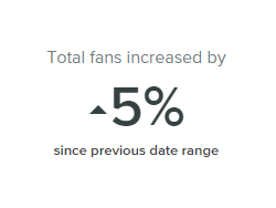
2. We hit another milestone in Facebook followers this period by crossing the 8,000 mark. We now
have a similar following to the Waikato DHB’s Facebook page.
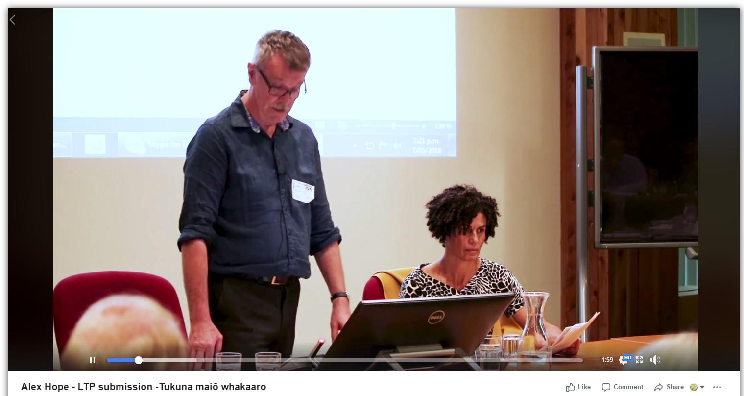
3. A highlight of the month was the video regarding our first te reo LTP submission – an organic post
that was shared approximately 678 times and is now the second most watched video on our
Facebook page.
4. We are launching a new interactive story telling app at Fieldays. It’s a simple way for farmers to learn
more about potential environmental issues around their farm and ways to mitigate these.
5. Work has begun to update our popular MarineMate safer boating app. This project has our customer
at its heart, incorporating customer feedback by app users into the design process.
Staff Recommendation:
That the report ‘Digital Communications Report for June 2018’ (Doc # 12553704 dated 7 June 2018)
be received.
Background
6. Over the past 12 months the Communications and Engagement Section has focused our efforts
towards increasing our digital presence, as part of multi-channel strategy to enable meaningful
communication with our communities. This report seeks to update councillors on the progress in
this space.
7. At the previous committee meeting, a request to compare our demographics with the national
average was received. A response is included in this report.
How we measure social media
8. Social media impact can be measured in a few different ways:
Page likes: An easy way to describe this is the number of ‘fans’ you have in your fan-club.
Reach: The number of unique people a specific post reaches. This is not limited to people who
like your page.


7
Impressions: The amount of times a post is seen by the people it has reached.
Engagement: Reactions a person has put on a post (like, dislike, love, sad, etc.).
Comments: The conversation occurring on a post.
Facebook results: 16 April to 31 May 2018
9. The following statistics relate to our Facebook activity, since the last report for the Strategy and
Policy Committee meeting to the date this paper was written (16 April to 31 May 2018).
Page likes
10. We reached the 8,000 follower mark this period. This is an exciting growth rate. We now have a
similar following as Waikato DHB’s Facebook page.
11. The most effective way we’ve increased ‘likes’ is by inviting people that interact with our content to
follow our page. You can see these as peaks in the graph below. This highlights our continued
reliance on interesting content to leverage off this technique. We had some very popular posts this
period which are described in more detail below.

8
Reach and impressions
12. Total impressions for the period were 994,600; reaching an average of 9,507 Facebook users a day.
Engagement
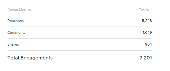
13. People have engaged/conversed with us a total of 7,201 times this period. This covers reactions,
comments and shares. This is still very high and almost on par with the previous period.
What got them talking?
14. The most popular post we shared was the video about the first te reo LTP submission. This was not
a paid promotion on Facebook, and it was heartening to see a large number of shares – 678. This is
an excellent demonstration of the power of social media – where others feel compelled to share our
content with their family and friends. This resulted in our content being viewed over 36,000 times.
15. The chart below shows the top four posts that received the highest reactions.

9


10
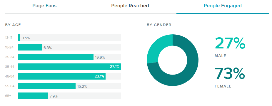
Demographics – who was interested this month?
16. Females aged between 35-44 years continue to be the most likely to engage with our content. We
saw a significant shift in the gender of people engaged compared to the previous period. Males
dropped from 40% to 27% and females jumped from 60% to 73%.
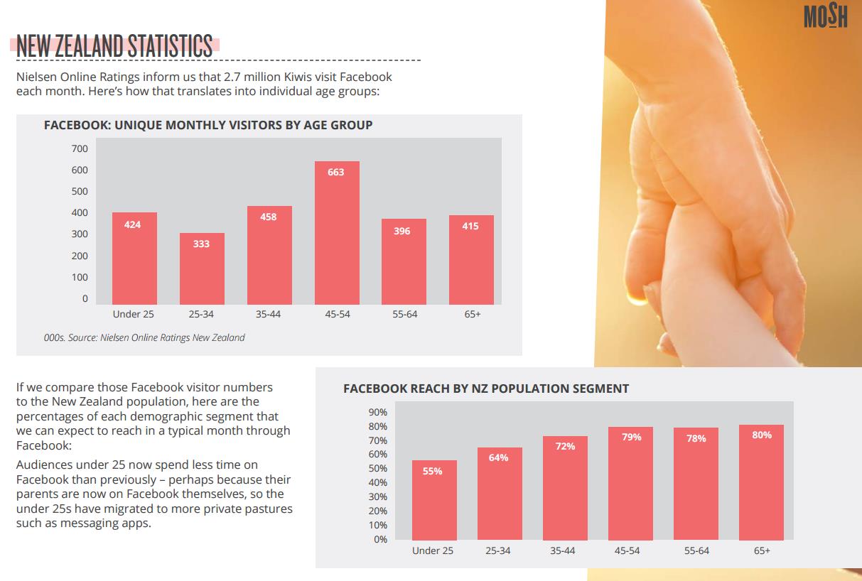
At the last Strategy and Policy meeting, Councillor Quayle asked us to compare the demographic
information against national averages to understand if we are reflecting the general population.
National averages are difficult to ascertain and are only investigated by social media companies and
marketing/research organisations.
Mosh (a social media company in Auckland) prepared a New Zealand Facebook Report for 2017. It
covers statistics about audience behaviour. However, demographics are only a small portion of their
research. Their findings are included below.
When comparing our age demographics with that of the report from Mosh, there are differences. We
are attracting a slightly younger audience – 35-44, where the largest population on Facebook is 45-55.

11
In terms of gender, 54% of New Zealand Facebook users are female. Our followers range from 60-70%
female and our engagement (the people who talk to us) ranges from 55-75% female, depending on the
month and the topics we are discussing. So we are attracting a higher skew of females compared to the
national average.
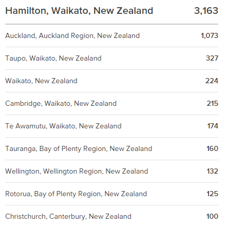
17. Following is our most recent table of the geographic spread of our followers.
What else has been happening digitally?
Healthy Rivers / Wai Ora interactive display for Fieldays
18. An interactive story telling app displayed on a touch screen will be launched at Fieldays. The app
will let users choose a farm related subject and drill down on details about environmental issues and
how to mitigate them. Some screen shots of the app are included below.
19. The next steps for this app is to build a content management system that will allow us to add/remove
content ourselves, making it a fully functional tool that council can use for internal and external
presentations. This is something we’ve been looking at for a while, having investigated other
interactive story
12
Up next
My Waikato
20. We are continuing with the promotion of the My Waikato app to encourage people to download
and use it. We shared a social media post about the app during the last period.
21. Our next focus is to generate greater exposure through media (newspapers and websites) of the
great work our Enviroschools are doing, and the support that Waikato River Authority provides to
community groups. This is info that we publish in the My Waikato app, and the media exposure will
be another way we can bring the app to people’s attention.
MarineMate app
22. We’ve teamed up with Maritime Services staff to improve the current MarineMate app, designing a
new app from scratch. The current app is difficult to update with new content and the current
platform is no longer able to be upgraded by the apps original developer.
23. We will be approaching this improvement process through a customer-centric lens, incorporating
feedback users have provided to us at various boating shows. We have just completed the design
plan and we’re very excited about how the new app will look and function.
Conclusion 24. The digital space is an exciting place to be working in. We continue to achieve strong results across
social media, videos and various applications, to make it easy for our customers to understand the
work we do and what we need them to do. Our expertise continues to grow as we experiment with
new techniques and tools.
13
Report to Strategy and Policy Committee
Date:
26 June 2018
Author:
Alejandro Cifuentes, Policy Advisor, Integration
Authoriser:
Tracey May, Director Science and Strategy
Subject:
Regional Policy Statement Implementation – 2017-2018
Section:
A (Committee has delegated authority to make decision)
Purpose
1. To update the Strategy and Policy Committee on implementation of the Waikato Regional Policy
Statement (WRPS).
Executive Summary
2. The Resource Management Act 1991 (RMA) requires all regional councils to produce a regional
policy statement for their region and
review it every ten years. The current WRPS is the second
regional policy statement developed by the council and become operative in May 2016.
3. This report is the second progress update of the WRPS, it covers the period from June 2017 to June
2018. The next update report will be presented to the Strategy and Policy committee in 2019.
4. The WRPS has 246 methods which are grouped into three implementation streams (internal,
external, programmes and projects). Implementation of the significant majority of methods is on
track.
5. Two methods have not been initiated, four are off-track and three have been halted. This is due to
resource constraints, changes in strategic direction or practical considerations around similar work
in other programmes.
Staff Recommendation:
That the report
“Regional Policy Statement Implementation – 2017-2018” (Doc # 11567376 dated 26
June 2018) be received.
Background
6. This report is the second annual progress update on implementation of the WRPS. The first update
titled ‘Regional Policy Statement Implementation – One year on’ (Doc # 10135300, dated 16 May
2017) was received by the Committee in May 2017.
7. These progress updates are important to ensure a continued focus on implementing the WRPS.
What is the WRPS?
8. The Resource Management Act 1991 (RMA) requires all regional councils to produce a regional
policy statement for their region and
review it every ten years. The current WRPS is the second
regional policy statement developed by the council and became operative in May 2016.
14
9. The WRPS identifies the key resource management issues in the Waikato region and how
integrated management of natural and physical resources will be achieved across jurisdictional
boundaries and agency functions. As well as setting out the role of the council in achieving these
outcomes, it identifies the contribution of other organisations in achieving a regional response. All
other regional plans prepared by the council and all district plans in the region must give effect to
the WRPS.
Implementation of the WRPS
10. The WRPS has 246 methods, which can be grouped into three implementation streams.
internal, external and various programmes of activity, as detailed below.
IMPLEMENTATION STREAMS
INTERNAL
EXTERNAL
PROGRAMMES & PROJECTS
REGIONAL PLAN AND REGIONAL
INFORMAL ADVICE AND SUPPORT
LOCAL INDIGENOUS BIODIVERISTY
COASTAL PLAN
FORMAL INVOLVEMENT IN DISTRICT
STRATEGIES
PLAN REVIEWS, PLAN CHANGES AND
WAIKATO HERITAGE FORUM
NON-STATUTORY PLANNING
MATAURANGA MAORI
INITIATIVES
NATURAL HAZARDS
WRPS LOCAL AUTHORITY
IMPLEMENTATION AGREEMENTS
Internal implementation
11. 68 of the WRPS’ implementation methods provide direction for the council’s regional plan and
coastal plan. These plans are the Council’s primary tools to give effect to the WRPS.
2017-2018 Implementation update
12. The regional plan and coastal plan are currently under review, and are to be combined into one
Regional Resource Management Plan (RRMP). Direction from the WRPS will inform the review,
and the development of the combined RRMP.
External implementation
13. 72 WRPS implementation methods provide direction to district plans. This implementation is
achieved through:
Providing informal advice and support to district councils at early stages of plan reviews and
plan changes
Council staff have prioritised working collaboratively with district councils during the early
stages of plan development and review. This early engagement ensures that district councils
understand the requirements of the WRPS at the outset so that they can be factored in from
the start. Council staff also work with district councils to align other non-statutory plans
prepared by district councils, such as growth strategies and structure plans, with the direction
set by the WRPS and other regional plans.
2017-2018 Implementation Update
Staff have provided support to, (or engaged with):
-
Waikato District Council’s current district plan review
-
Staff from Waitomo and Taupo District Councils during the early stages of their district
plan reviews
-
Staff have engaged Waipa District Council’s structure planning exercise for growth cells
around Cambridge
-
Future Proof partnership for the ongoing review of the Future Proof Strategy.
15
Formal involvement in district plan reviews, plan changes and non-statutory planning
initiatives
14. The council prepares and lodges formal submissions, to district councils on their district plans, and
to other agencies on their strategies and proposals. Where necessary, the council also becomes
involved with appeals to the Environment Court, to ensure the WRPS is given effect to.
2017-2018 Implementation Update
-
Over 11 submissions were lodged to district councils’ plan changes in the region.
-
Four submissions were lodged to regional and cross boundary plans and strategies,
including to the draft 2017 Future Proof strategy and the draft Waikato Plan.
-
The council is a party to several appeals to the proposed Thames-Coromandel District Plan
and is working with Thames-Coromandel District Council (TCDC) staff and other parties to
ensure that the WRPS is given effect to.
WRPS Local Authority Implementation Agreements (LAIAs)
15. LAIAs were included as a method in the WRPS at the request of district councils who wanted
clarity over how the council will work with and support them to give effect to the WRPS. Staff
have continued to work with district councils to develop LAIAs where there is demand.
2017-2018 Implementation Update
-
Waikato District Council and Waitomo District Council’s agreements are on track for
completion in 2018.
-
TCDC’s agreement has been drafted and is to be completed once the appeals to the
Proposed Thames Coromandel District Plan are resolved.
-
Hauraki District Council staff have requested that their agreement be prioritised as a
vehicle to agree priorities for the management of natural hazards, including flood
management and drainage infrastructure.
Programmes and projects
16. The remaining methods (approximately 120) refer to working with others, including with district
councils and community groups, to establish research projects, education programmes, strategies,
collaborative forums. Currently, there are over 50 internal, Council-led work programmes that
assist with implementing these methods.
17. The most recent staff stocktake of these work programmes (refer to Attachment 1) shows that
over 75% of the work has been achieved, is being progressed or will continue to be progressed
through the council’s ‘business as usual’ activity. Through this, approximately 70 methods are
being implemented.
18. Key projects where significant progress has been made since the previous update are discussed
below.
Local Indigenous Biodiversity Strategies (LIBS) – The objective of this programme of work is to
develop locally specific strategies for indigenous biodiversity, based high quality spatial data.
Pilots are currently being implemented at Hamilton City Council, and South Waikato and
Matamata-Piako District Council, these strategies achieve methods 11.1.5 and 11.1.11 in the
WRPS. The pilots will inform how the approach may be scaled up for implementation across
the region.
Waikato Regional Heritage Forum – During 2017 the council established a Regional Heritage
Forum (the forum) to improve understanding, information sharing and cooperative planning
to manage and protect heritage resources across the region. Establishing the forum achieved
WRPS method 10.1.1 and enables 10.1.2 and 10.1.3 to be progressed. The forum has met twice
since its formation, in November 2017 and April 2018, and has its next meeting scheduled for
October 2018.
16
Mātauranga Māori – This internally-focussed project aims to develop an agreed framework
and process for integrating Mātauranga Māori into activities throughout the Council.
Mātauranga Māori refers to both the knowledge Māori have and the Māori world view and
perspectives. Phase one developed an understanding of Matauranga Maori research, concepts
and model frameworks used by iwi partners. Phase two consists in writing the project plan for
implementation. Work in this phase is underway, it will comprise an internal stocktake to
understand how Mātauranga Māori is incorporated in work programmes, planning and
monitoring; it will involve collaboration with iwi partners, to learn about the way in which they
approached similar project within their organisations.
19. Key focus areas where future work is necessary for implementation
Move from implementation monitoring based in work programmes to one based on outcomes is
considered advantageous. Work for the current stocktake identified that due to resource
constraints, changes in strategic direction or practical considerations around similar work in other
programmes, some activities have not been progressed in its originally intended structure. A
significant challenge where changes have occurred is to accurately capture the efficiency and
effectiveness of the work being carried out.
Chapter 6 of the WRPS. Various methods and data tables within the built environment provisions
will need to be updated as a result of changes to the National Policy Statement on Urban
Development Capacity (NPSUDC), anticipated to be published by December 2018. This includes
setting minimum targets for feasible development capacity in high growth areas. This work is being
jointly undertaken with Hamilton City Council, Waikato Regional Council and Waipa District Council
through the Future Proof partnership.
20. It is noted that the Council has requested a report on the implementation of WRPS direction on
natural hazards in Ngatea. This report will be presented to Council in August this year.
Conclusion
21. Through the three implementation streams, the majority of the WRPS is being implemented. As
part of ensuring a continued focus on implementing the WRPS, the annual update report will be
presented to the Strategy and Policy committee in early 2019.
Assessment of significance
22. To the best of the writer’s knowledge, this decision is not significantly inconsistent with nor is
anticipated to have consequences that will be significantly inconsistent with any policy adopted
by this local authority or any plan required by the Local Government Act 2002 or any other
enactment.
Attachment:
1. Overview of Waikato Regional Policy Statement implementation through projects,
programmes and business as usual activities to date.
17
Attachment 1: Overview of Waikato Regional Policy Statement implementation through projects, programmes and business as usual activities as at
December 2017
These projects, programmes and activities were identified as being required to assist with implementation of the WRPS. It is not expected all the WRPS
methods will be implemented immediately, but this will occur over the 10 year life of the plan.
On track
Off track
Halted
PROJECT
PROJECT NAME
PROJECT DESCRIPTION / UPDATE
RPS POLICY LINKS
STATUS
TRW audit and
This multiyear project relates to understanding how Matauranga Maori can be incorporated
Matauranga Maori
into Waikato Regional Council’s (the council’s) work programmes.
Phase one of the project increased understanding of Matauranga Maori research, concepts
and model frameworks used by iwi partners. This enabled Tai Ranga Whenua (TRW) to
develop implementation project plan and an implementation methodology to identify all the
4.1, 4.3, 8.1,
projects in the Council that should have a Matauranga Maori component. TRW will submit a
8.5
draft strategy to the project's steering group for approval by September 2018.
Phase two of the project is underway. Work has begun to gather information within the
business, this also involves collaboration with iwi partners, to learn about the way in which
they approached similar project within their organisations.
Citizen Science
The work in this area aims to develop a framework that functions as a tool for community, to
help them address key elements in the development of community monitoring initiatives. The
objective is to ensure good outcomes for the environment, through education and promotion
of environmental care to achieve efficient resource management.
4.1
During 2016-2017, initial research and networking were carried out, and the base concepts
were drawn. Currently a draft framework is being developed. The work consists in meetings
and interviews with community stakeholders, seeking input from different Council business
18
units interested in the development of such a project/tool. The draft framework focuses
mainly on prompts for the community to think about significant steps when developing a
project, e.g. area of concern: are there similar projects already in the vicinity? Consider
methods.
A report is due with the Strategy and Policy committee by later in 2018.
RPS Local Authority
The RPS
Local Authority
Implementation Agreements (LAIAs) are council- initiated documents
Implementation
prepared in collaboration with each of the 11 territorial local authorities in the region. They
Agreements
specify actions both the council and each local authority will take to progress implementation
4.2
the WRPS. The Policy Implementation team are working to have the 11 agreements approved
by the end of 2018.
Information management
This work stream includes two distinct projects:
1. To develop a common spatial information depository with all district councils in the
Waikato region. A business case is being prepared for this project and it is currently
on track.
2. To collaborate with other regional councils across NZ to develop a data warehouse. It
will include information on environmental benchmarks and regulatory processes such
4.2
as consenting.
The Regional Council Chief Executives Forum endorsed a proof of concept, noting the
potential viability of the projects, and an associated proposal in late 2017. Currently, the
process is being driven through the Corporate Service Special Interest Group to further
develop the data warehouse.
Community surveys
The council undertakes community surveys to better understand the different ways resources
are valued by people and communities. The information is used to promote an integrated
approach to resource management. The last survey was completed in 2015 through the 'Your
4.1
environment - What happens' survey. The survey will be reviewed in 2018 with a view to
undertaking it again in 2019.
Air quality Monitoring
This is an on-going programme of work which includes:
Education and Advocacy
an air Quality Working Group
air education and advocacy, a programme for wood burner installations (records of
5.1, 5.3
number of wood burners installed are available)
air quality monitoring
19
Responding to complaints and enforcement.
The recent change of government has brought a higher degree of climate change emphasis.
This will likely have implications for emission targets, transport emissions and farm emissions.
A change in climate change emissions would likely mean in change in other types of emissions
that affect air quality. Any central government policy changes will likely require significant
review of WRPS air quality policy and implementation methods in 2018.
Information collection on
This is an ongoing council activity. It requires involvement in monitoring the Future Proof
development and
Strategy’s implementation plan, and the Regional Land Transport Plan. The council is involved
6.8
infrastructure trends
with monitoring outcomes of both documents.
Transmission
This is a WRPS implementation method that directs the council to work with district councils
management corridor
and energy companies to ‘develop a transmission corridor management approach’. This is
6.6
approach
currently considered a low priority method and the project has not commenced.
Efficient resource use
This work stream stems from the role of local authorities to undertake advocacy in encouraging
advocacy and promotion
energy efficiency, and the RPS direction for the regional council to call on district councils to
implement provisions that promote planned and coordinated development. This work requires
the Council to have a clear position on ‘good’ or sustainable urban development. Initially this
work stream will involve the development of guidelines to comment/submit on development
proposals and statutory plans.
6.1, 6.5
This programme of work requires the development of a guidance note for efficient resource
use and continuing management of a cross-regional waste forum (community and industry
group). Due to restructuring of the Education team and the early stage of development of
relationships with external stakeholders the guidance note has not commenced. A waste
forum has been established and continues to be undertaken as part of the council’s ongoing
programme of work.
The Regional Asset Management Plan is currently being developed and is expected to be
Asset management and
finalised by the end of 2018.
zone plans and
6.6
infrastructure strategy
Several zone plan reviews are currently underway, with others expected to commence over
coming years.
20
ICM is developing the Regional Infrastructure Strategy as part of the Long Term Plan, and is
expected to be adopted in line with the broader LTP development project.
Networking and
This is an ongoing work stream to ensure council participation in relevant forums and
participation in forums
networks, such as the Transport Special Interest Group, Future Proof, State Highway 3 (SH3)
working group, State Highways 1-29(SH 1-29) working group, Regional Road Safety Forum and
6.3, 6.6
Community Transport Forum. Participation at these forums helps achieve coordination of
growth and infrastructure.
The development of programmes of work for transport implements a number of transport
related policies. These programmes include the Regional Road Safety Strategy, the Regional
Transport planning
6.5, 6.6, 6.7
Cycling business case, and the Regional Access and Mobility Project business case. Work in
this area is currently on track.
Marine Water Quality
The main aim of this work stream is to provide scientific information to ensure that discharges
identification and
to marine waters are managed to maintain or enhance the mauri and health of marine water
monitoring
and to protect ecosystem, amenity, and tangata whenua values.
In early 2017 data was gathered to identify different types of marine water within the region
and ensure their quality is maintained, or improved to meet standards. This data was relayed
to the Policy team to inform policy on marine water quality. Work in this area feeds into the
7.2
review of the Regional Coastal Policy Statement.
Monitoring and investigation are carried out as part of business as usual, to identify trends
and find the sources of particular problems around water quality, from a scientific point of
view. Investigation entails observation/monitoring over a long period of time and
investigation is carried out ad hoc, as a one-off process.
Work with primary
Work is underway in the Waipa and Waikato Catchments to jointly implement the provisions
industry to manage land
of Healthy Rivers Wai Ora (Plan Change 1 to the Regional Plan) with industry. Current work in
use activities and effects
the Hauraki and Coromandel catchments focuses on preparing the agriculture industry for
8.1, 8.3, 8.4
from nutrients on water
Regional Plan Change 2 (Hauraki/Coromandel Water Quality).
quality
21
Water conservation
This is an ongoing programme of work made up of the following components:
management
• The council’s Land Management Advisory Service collaborates with the dairy industry water
group to promote water conservation.
• Resource Use Directorate, through resource consent processing.
• The Policy Implementation team, through its advocacy and support for the uptake and
8.7
encouragement of water efficiency through district plan reviews, plan changes and
development consents.
• Council’s customer and community partnership programmes, including through educational
activities with schools.
Freshwater catchment
Council’s Integrated Catchment Management's (ICM’s) biodiversity team plays a major role in
based on intervention
terms of technical support, drafting and delivering catchment plans. ICM presented a business
case to the Integrated Catchment Management Committee in late 2017, with the aim to
increase outputs by drafting additional catchment management plans.
Council will set in place a region-wide catchment management approach that is linked to
specific plans over 10 years.
Catchment planning involves the development and implementation of zone, catchment,
harbour and shallow lakes management plans in collaboration with stakeholders and the
8.4
wider community. Catchment management involves talking with landowners and managers
on property level plans or agreements aimed at reducing erosion, improving water quality and
biodiversity enhancement; catchment maintenance works where pre-existing
works/agreements are checked to ensure gains are maintained; implementation of
restoration and enhancement projects, including large scale collaborative commitments (e.g.
Waikato Catchment Ecological Enhancement Trust, Waikato River Authority); and the
monitoring and coordination of soil conservation schemes and other non-scheme works to
ensure works are maintained and provide the service and undertake the function they were
constructed to, mainly aimed at maintaining soil stability.
Freshwater information
This work stream was initiated to support the Healthy Rivers Wai Ora plan change (Plan
gathering
Change 1 to the Waikato Regional Plan), and included identifying critical source areas and
8.1
understanding activity and pathways for key contaminants. Information gathering is still in
3.8 (objective)
development. This work will continue in order to support the regional plan review and other
policy related projects.
22
Management of lakes
This involves assessment of the utility of a number of scientific indicators used to routinely
project
monitor shallow lake health across the region. The Science team has developed an existing set
8.3
of indicators and is assessing the development of new ones. This is an ongoing work stream.
Community education on
This work stream calls for the Council’s involvement with direct improvement of geothermal
geothermal areas
sites (primarily weed control) with some advocacy to make landowners and district councils
more aware of the value of geothermal sites.
The Science team, ICM and RUD jointly carry out community education work, on an ad-hoc
basis. This work includes signage and talking to landowners in geothermal areas and areas of
9.1
geothermal vegetation, and is done as part of BAU, when required.
The Science team partners with DOC and tourism agents to develop information material and
signage. As part of its functions, the Science team participates in conferences, produces
scientific papers for journal publication, talks to community groups and publishes in WRC's
magazine, which all serve as educational material for communities in geothermal areas.
Geothermal research and
The Land and Soil Science team carry out research and monitoring as a requirement of section
monitoring
35 of the RMA to ensure that sufficient knowledge and information are available about each
geothermal system and the effects of its use, to enable better management and respond to
potential and existing beneficial and adverse effects.
Research and monitoring are ongoing tasks. Investigation has an ad-hoc nature. Some
examples include the information gathered after hydrothermal eruptions, newly discovered
geothermal features and/or changes of behaviour of a feature or a set of features.
9.1, 9.8
Additionally, as part of the Science team’s standard budget, ad-hoc research can be carried
out by engaging external experts.
Method 9.8.2 proposes that local authorities should support, and where appropriate
facilitate, the development of hapū and iwi geothermal management plans. Work was being
undertaken in this area but was put on hold due to a shift in organisational priorities of the iwi
partner. The land and soil team are currently looking at approaching other iwi to carry out his
work.
23
Geothermal support for
The WRPS requires the council to assist iwi in the development of geothermal management
iwi and hapu
plans. To date, no such assistance has been requested by iwi.
9.8
management
Geothermal peer review
This project’s aim is to continue to use the peer review panel set up pursuant to method 9.3.3
panel
of the WRPS. This is a requirement of active monitoring and compliance of major geothermal
9.3
energy providers.
Planning for effective
Tai Ranga Whenua completed the development of a Maori Engagement Framework in 2017.
engagement with Maori
The framework produced the draft for the Significant Engagement Policy. The draft was
Strategy
presented to the Strategy and Policy Committee on November 2017. The committee set up a
workshop to seek further information and gain consensus for endorsement. Tai Ranga
10.2
Whenua ran a workshop for Council elected members in February 2018.
The draft of the Maori Engagement Framework was adopted by full council on March 2018
(WRC 18/64) and the Significant Engagement Policy was updated to include it.
Establishment of a
In 2017 the Council facilitated the establishment of a region wide Heritage Forum, which will
10.1
heritage forum
continue to be convened on at least a half-yearly basis.
Biodiversity funding
This work stream involves Biodiversity staff and catchment management officers working to
assistance
develop biodiversity plans with landowners. This is part of council’s ongoing work
11.1, 9.1
programme, and is on track.
Biodiversity Information
The Science team is tasked with the development of a regional dataset for indigenous
Gathering
biodiversity. To achieve this:
an inventory is to be completed by June 2019
11.1, 11.2, 8.2
biodiversity indicators are being developed as part of a national indicators set that
will become part of a national biodiversity framework.
Biodiversity strategies
This project involves the Council assisting district councils to develop local indigenous
biodiversity strategies, and collaborating with others. Currently the Local Indigenous
Biodiversity Strategy (LIBS) pilot programme is being undertaken to develop and test the
biodiversity implementation framework and toolbox.
11.1, 11.2, 8.2
The two pilots currently being implemented are the Hamilton City pilot and Source-to-sea (Te
Puna o Waihou ki Tikapa te Moana, with South Waikato and Matamata Piako District
Councils). The Hamilton City pilot has tested this innovative approach to biodiversity within an
24
urban environment and complements the Source to Sea pilot which tested this approach in a
largely rural catchment.
The LIBS project is two thirds of the way through a 3 year programme and making significant
progress.
This method is key to implementing RPS biodiversity policy at the district council level and
particularly for terrestrial and wetland biodiversity.
During the final year of the project an evaluation of the pilots will inform how the programme
can be scaled-up to be implemented across the region.
Confirmation of ONFL
The WRPS gives direction for the council to work with tangata whenua to confirm their values
values to tangata whenua
of significance to areas identified as outstanding natural features and landscapes (ONFLs).
Policy Implementation is undertaking early scoping of this project to inform a project plan. It
12.1
is anticipated a project plan will be drawn up and a business owner will be identified in the
second half of 2018.
Natural Hazards Strategy
This work aims to identify primary hazards zones and the natural hazards component of the
and Implementation
regional plan. The project is on hold due to unavailability of sufficient technical resourcing in
13.1, 13.2, 13.3
the Regional Hazards team.
Soils education and
This project aims to maintain or enhance the life supporting capacity of the soil resource. Part
advocacy project
of ICM’s work under the Biodiversity Funding Assistance work stream flows into this project.
The Council’s Natural Heritage Fund is run as part of the ongoing work programme, to protect
and manage, in perpetuity, special places of ecological significance. Key priorities include the
14.1, 14.3, 14.5
preservation of access to waterways and the coast, as well as protection of biodiversity,
heritage sites and landscapes of significance to the community. To date, the Natural Heritage
Fund has been used for a wide range of projects including Maungatautari Ecological Island
Trust, Waipa peat lakes reserves and the purchase of the Ed Hillary Hope Reserve.
Soils - provision of high
To implement this method there is a need to provide regional scale coverage of high class
class soils information
soils information and the development of protocols for the use of soil information and its
interpretation for the assessment of subdivision. The Land and Soil team requested funding
14.2
for this work stream during the 2015 Long Term Plan (LTP) process. No specific budget has
been allocated to date.
25
Soils research
This is an ongoing council activity and mainly involves investigation and monitoring of soil
quality. The main aim is to use research to maintain or enhance the life supporting capacity of
14.1, 14.3, 14.5
the soil resource, minimise contaminants in soils and manage the adverse effects of activities
resulting from use and development of peat soils.
Contaminated Land
The fund was set up as part of the “Contaminated Land Strategy,” in order to identify and
Investigation Fund
manage contaminated land to ensure human, plant and animal health, and water, air and soil
quality are protected from unacceptable risk.
14.4
This fund sets out four key focus areas: integrated information management, high-risk site &
activity investigation, establishing a new contaminated land investigation fund and advocacy
and stakeholder engagement. These have been achieved.
Regional pest
The Council is reviewing the current Waikato RPMP because it is inconsistent with the latest
management plan
National Policy Direction for Pest Management, the council’s strategic direction and is failing
11.1, 11.2, 14.1
to meet some of its own objectives. The review is programmed for year 2018 to 2020. WRPS
biodiversity objectives can be met in part through the Waikato RPMP.
Economic instruments
This project identifies and assesses the feasibility, effectiveness, including cost-effectiveness
and efficiency of a range of economic instruments as a way of achieving water quality
4.1, 11.1
objectives. It was initiated to support Plan Change 1 to the Regional Plan (Healthy Rivers), and
will continue as part of the council’s ongoing work programme.
Coastal Marine Strategy
The WRPS provides direction for the council to develop a Coastal Marine Strategy for the
coastal marine area. Its purpose is to optimise the opportunities provided by ecosystem
services for regional economic, social, cultural and environmental wellbeing. The strategy is
not a priority project for Council and there is currently no specialist staff to progress it. The
Regional Strategy team have developed high level objectives, and further input from ELT and
the Policy team is expected before further work is carried out.
4.1, 4.2, 6.3,
7.1, 7.2, 11.4,
However, the Seachange project is currently undertaking some of the work required to
12.3, 12.4, 12.6
develop a coastal marine strategy, but only for east coast areas. Council can only progress
further developments at a strategic level related to West coast harbours once the relevant
work is undertaken with iwi.
Work on a Regional Aquaculture Strategy forms part of the wider Coastal Marine Strategy,
and is being driven through the Regional Aquaculture Forum, administered by WRC, and
26
comprising representatives from industry, central and local government agencies and iwi. A
preliminary draft strategy was presented to the Forum in April 2018 as an update noting that
it requires further expansion of scope to best align with current regional economic
development drivers. Contracted services will be secured to further develop the strategy and
to ensure stakeholder buy-in to this work. Ben Bunting, Principal Advisor Science and
Strategy will provide oversight.
River and Catchment
This activity aims to develop an internal practice note/Standard Operating Procedure to capture
Services practice notes /
the amenity and geothermal requirements of the RPS into the work of ICM.
Standard Operating
Procedures
Work has been done in the recently reviewed 2017 Taupo Zone Plan (P25), at a strategic
direction level, taking direction from the RPS to develop implementation actions. The Zone
Plan’s indigenous biodiversity action seeks to prioritise the protection and enhancement of
geothermal, through collaborative opportunities wherever possible. Local staff incorporate this
4.1, 4.4 4.2,
in their BAU activities, which includes looking for opportunities where they can work with
6.1, 6.2, 6.9,
partners (e.g. iwi, district council) and where possible the natural heritage team (ICM) for
6.10, 9.3,12.3,
support (advice and resource) in undertaking restorative actions for works in geothermal areas.
12.4, 12.5
However, work in this area has not progressed in its originally intended form, as described in the
RPS implementation work stream template.
A business case for the development of an SOP for amenity values was expected to be
developed in preparation for the 2018 LTP; this is yet to be produced. This project was
scheduled to commence in 2018.
Ecosystems services
The activities in this work stream seek to quantify in decision-making the benefit that people
projects
and the economy obtain from ecosystems (the natural world).
Some activities are undertaken by the Science and Strategy team as part of business as usual.
4.1, 7.1, 8.3,
Activities are currently taking place in three areas:
11.1, 14.1
1) Coastal (Valuing Coastal Environment)
2) Soil (soil strategy)
3) Integrated (Hauraki Integrated Assessment)
27
The Social and Economic Science team will undertake an economic evaluation of ecosystem
services as part of their business as usual activities.
Changes to consenting
There is no specific council project to identify changes to the consenting process. However, as
project
part of its ongoing work programme the Resource Use Directorate (RUD) looks for ways to
4.1, 8.3, 11.1,
adjust its existing processes to new rules, with the aim of ensuring that the WRPS is
11.3
appropriately considered when making decisions on regional consents.
WRPS Monitoring
Monitoring of the WRPS is required every five years. Work has started to support this process,
Chapter 15
but will be prioritised closer to 2021, when the reporting is required.
28
Report to Strategy and Policy Committee
Date:
11 June 2018
Author:
Harvey Brookes, Contractor
Authoriser:
Tracey May, Director Science and Strategy
Subject:
Waikato Regional Economic Development Agency update
Section:
A (Committee has delegated authority to make decision)
Purpose
1.
To provide an update on progress being made to establish the Waikato Regional Economic Development
Agency.
Staff Recommendation:
That the report
‘Waikato Regional Economic Development Agency update’ (Doc # 12599957 dated 11 June
2018) be received.
Executive Summary
2. In late 2016, Waikato Means Business commissioned MartinJenkins Ltd to undertake a review of the
Waikato region’s economic development capacity and capability. The review assessed the current state of
economic development governance, funding and service delivery in the Waikato. The process included a
documentation review, research, and consultation with local authorities, industry groups, economic
development/tourism agencies, Māori/iwi organisations, businesses and central government agencies.
3. In June 2017, MartinJenkins presented its findings to the Waikato Means Business Governance Group. In
summary the review found:
The Waikato is one of the few regions in New Zealand without an EDA
There are a range of economic development strategies and frameworks across the region, with limited
alignment between them
Although an excellent start and a well-developed framework, there has been limited buy-in to WMB
strategy/plan and process
The business community is seeking a stronger voice and economic ambition for the region
Overall there are fragmented and uneven economic development services. Limited reach of some
services
There is widespread demand for improved investment attraction and facilitation, innovation and
industry/major project support
Currently there is limited local government resourcing - $20 per capita (rest of New Zealand $36), with
limited scope to increase this significantly
There is potential to leverage resources from other sources (e.g. private sector, WEL Energy Trust,
SWIF, central government).
4. The Group received and fully endorsed the findings of the review and asked that the project put more
shape on the form, function, funding and governance elements of a potential new entity – Waikato REDA.
The chair of Waikato Means Business held further discussions with executives of the Waikato Innovation
29
Park and Hamilton City Council, the Waikato Mayoral Forum and the Waikato Regional Council Strategy
and Policy Committee. All these groups supported the findings of the review and the general model
proposed. The Board of Hamilton Waikato Tourism also considered the recommended changes and
advised Waikato Means Business of their support. Presentations were also made to the elected members
of all councils.
5. In October 2017, a pre-establishment Project Team and process commenced, and a Reference Group was
formed. The overall purpose of the process and Reference Group was to confirm how the Waikato REDA
would be established, the expectations for Waikato REDA’s operations over the short- to long-term, and
funding support from local government and other economic development partners. More specifically, the
Project Team and Reference Group were asked to report to the Mayoral Forum on:
The objectives and form of the entity, including governance
The scope of the entity’s operations for the short-term and medium-term and intended long-term
activities
Any legislative requirements with respect to establishing the entity
Establishment and leadership
An establishment plan/process
Risks from the establishment and ways of managing these
The expected costs of establishment and funding contributions from councils and other partners.
6. The process also involved engaging and consulting with a range of stakeholders to confirm the objectives
and initial functions for the new entity, its potential role in the longer term, and working relationships with
economic development partners. Discussions have been held with Chambers of Commerce, Export New
Zealand, Soda Inc, Wintec, the University of Waikato, Otorohanga District Development Board, NZTE and
the councils. The Chairs and/or Chief Executives of the main tribal iwi organisations in the Waikato have
also been contacted to discuss the most effective way for them to be engaged with the REDA establishment
process.
7. In March 2018 a Waikato REDA Establishment Board was appointed by the Waikato Mayoral Forum. The
Establishment Board commenced the process to establish the Waikato REDA and to govern its initial
development. The members of the Establishment Board are:
Dallas Fisher (Chair)
Les Roa
Kim Hill
Chris Joblin
Kiri Goulter
Blair Bowcott (local government representative)
Rob Williams (local government representative).
8. The Establishment Board is responsible for:
Assigning an interim Chief Executive (Stuart Gordon) to oversee the establishment process and to
ensure that the 1 July establishment date is met. Stuart is managing both the process and Waikato
REDA until a permanent Chief Executive is appointed.
Finalising a service level agreement with Waikato Innovation Group Ltd in relation to administrative
and support functions.
Finalising a service level agreement with the councils, based on agreed priorities and activities.
Finalising any funding arrangements that are possible with businesses, industry groups and other
economic development partners.
Preparing the first business plan for the new entity based on the service level agreement with councils.
The business plan would set out the purpose, objectives, activities, budget, performance measures
and reporting requirements of the new entity. The initial business plan would be relatively simple and
be for the first year of the agency’s operations.
Recruiting for and appointing a permanent Chief Executive.
30
Objectives and Functions
Objectives 9. Clear objectives are needed to ensure that Waikato REDA is focused on the doing the right things and to
clearly communicate to the business and wider community what the agency is fundamentally about.
10. The objectives need to be broad enough to cover the range of activities that the agency will undertake
(without needing to change the objectives in the deed or constitution over time) but still provide a good
sense of the agency’s reason for being and what it is trying to achieve.
11. The Reference Group considered the findings of the review of economic development arrangements and
examples of objectives from various economic development agencies across New Zealand. Based on this
and feedback from stakeholders and businesses, the Reference Group agreed the following high-level
objectives for the Waikato REDA. These were reviewed and, with some very slight adjustment, approved
by the Establishment Board in March:
Figure 1: Waikato REDA Objectives
Short- to medium-term functions (first 12-36 months)
12. Although the above objectives indicate long-term intentions, there is a need to be realistic about the
establishment process and what is achievable in the first few years. The experience of EDAs in New Zealand
is that it takes at least three years to get an EDA up to full operation and that five years is more likely (e.g.,
the experience of ATEED, Wellington REDA, Central EDA). However, at the same time, the entity needs to
convince partners and the business community that it is credible.
13. Waikato REDA will deliver a combination of existing and new services over the first three years. In terms
of new services, there were clear demands that emerged from the review of economic development
arrangements and there are also new opportunities that are materialising that the agency will need to
have the capability to respond to. These are to:
Advocate for key economic development priorities for the region that will result in transformational
change. A key role of the REDA in the first year will be to identify these priorities in consultation with
economic development partners and the business community. It will then support the development
of these priorities through its services and networks. The Waikato Economic Summit will be central to
this process.
Develop an investment attraction and facilitation strategy and capability to coordinate regional
investment proposals and opportunities.
31
Work with industries to identify and facilitate major industry project opportunities that may be
suitable for co-investment through the private sector and central and local government, including
through the Provincial Growth Fund.
14. These new services will help the agency to demonstrate some major wins in the first few years of operation
to prove its success to partners and the business community.
15. In terms of existing services, the agency will:
Extend the business development and innovation services of Waikato Innovation Group Ltd. This is
naturally a core role, given Waikato REDA is being built around the business growth team of the
innovation park. This will involve providing business assessments, facilitating access to NZTE,
Callaghan Innovation and Business Mentor NZ support, supporting the commercialisation of high value
food innovation and facilitating access to the Food Innovation Network.
Continue to develop, promote and leverage the Waikato Story.
Work with central government agencies and local authorities on the 14 currently funded projects from
Waikato Means Business, including the Southern Waikato Economic Action Plan.
16. The agency will then need to develop and extend its economic development services over time, including
the reach of its services across districts. This includes building up its relationships with Māori/iwi/hapu
organisations to deliver services to support Māori economic development and the implementation of the
Māori Waikato economic development agenda and action plan.
Form 17. Experience in other regions indicates the agency would be best established at arms-length from councils.
The Steering Group for the review of economic development arrangements recommended that the entity
be established as independent of council control, i.e., not a CCO. The Reference Group and REDA
Establishment Board has agreed with this on the basis that an independent entity:
may introduce greater innovation in service delivery as it operates outside of a council structure and
is closer to the private sector
is likely to have more of an industry and commercial focus than a CCO
may also have an increased ability to leverage private and non-government sector resources and be
more attractive to private sector expertise at governance and staff levels.
18. The Waikato REDA will therefore be established through the formation of a Trust, which will own the REDA
as a company. This provides REDA with all the advantages of a company structure but allows the company
to be independent of councils through ownership by the Trustees of the Trust. The Mayoral Forum
considered this option on 12 February and indicated they were comfortable with this approach.
19. Trustees will be two independent non-elected people/positions, with acknowledged regional economic
wellbeing interest. We are currently in discussion with potential trustees.
Waikato REDA Governance 20. The Establishment Board will be operational for 6-9 months to get REDA up and running. The Establishment
Board will then be replaced with the first Waikato REDA Board.
21. The skills and experience of the Board of the agency post-establishment should differ somewhat from the
Establishment Board to reflect the different roles, i.e., there will not be such a need for establishment
experience and more of a focus on development. The Board will be responsible for:
Determining and overseeing the work programme of the Waikato REDA, its priorities and the
expansion of its services over time to meet those priorities.
Securing further funding sources over time to generate sufficient funds for the work programme.
Ensuring that REDA meets its priorities and performance targets.
Upholding the principles of good governance.
32
22. The Establishment Board will be responsible for the formal appointment of the Board members via a public
call for expressions of interest. Board members will be selected based on their skills and experience,
although representatives should be drawn from a range of industries of relevance to the economy.
23. To ensure a robust process is followed, the Establishment Board will use a recruitment process to select
directors. This would involve a public call for expression of interest from potential candidates and
encouraging industry groups and partner organisations to put forward suitable applicants. A short-list of
applicants would then be assessed. Having an independent recruitment process will avoid any potential
conflicts of interest, and will ensure that the REDA is not, by default, a CCO.
24. There will be no elected representatives or sector representatives/advocates on the Board. However, given
the important role that local government plays in economic development, and given the not insignificant
funding contribution that Waikato councils are making to the REDA, an appropriate form of input into the
Board selection process is considered important.
25. The Mayoral Forum has agreed that as part of the selection and appointment process for the final REDA
Board, that the Mayoral Forum be invited, at the appropriate time, to nominate two people to be on the
REDA Board. The people nominated would:
need to meet the skills and experience selection criteria1 for all Board members
note be elected members or employees of any local authority or CCO in the region
be independent directors and not “representatives” of the Mayoral Forum.
26. This process will provide the forum the opportunity to consider the makeup of the REDA Board and
consider whether there are any gaps in skills, geographic spread, cultural skills/competencies or other
factors which could be filled through appropriately skilled and qualified directors. Subject to final
confirmation which we will report back on at the forum meeting, legal advice is that this process will not
cause the REDA to become a CCO.
27. The minimum number of directors for the REDA will be 5 and the maximum number of Directors will be 9,
with a preferred compliment of 72, of which two are recommended by the Waikato Mayoral Forum as
above. Board members will be appointed on staggered terms.
Accountability 28. On 12 February the Mayoral Forum determined that Waikato REDA should be accountable to the Waikato
Plan Leadership Group or the Waikato Mayoral Forum. The broader representation on the Waikato Plan
Leadership Group and its ability to make formal decisions in relation to Waikato REDA’s expectations,
service level agreement and resourcing provides it with key advantages over other options.
29. In addition, this arrangement should help to ensure that major economic development priorities and
projects (as delivered by Waikato REDA) are well aligned with the Waikato Plan. It will also help the
Leadership Group to have a stronger overview of economic development across the region and to
understand how other elements of the Waikato Plan may best support economic development efforts.
30. The Waikato REDA will report six-monthly to the Waikato Plan leadership Group, including a discussion on
the strategic priorities in the business plan and on its annual report.
31. To ensure that all councils are kept informed about Waikato REDA’s progress and performance, the REDA
will also update the Mayoral Forum on a six-monthly basis on how it is performing against its business plan
and on priorities for the coming months. These accountability arrangements are summarised in Figure 2
.
1 These will be formalised in a Board selection policy which will form part of the terms of reference of the Waikato REDA Board
2 The Boards of most EDAs in New Zealand are between 5 and 9 (Northland Inc: between 2 and 9; ATEED: no more than 7; Priority One:
minimum of 7 members; Venture Taranaki: between 4 and 7; CEDA: between 5 and 7; WREDA: between 4 and 10; Nelson RDA:
between 5 and 7; ChristchurchNZ: between 5 and 10.
33
32. As part of the REDA’s key stakeholder relationship programme and considering the role of local
government as key funders, a series of partnership/funding agreements are currently under development.
These will cover three groups:
Funding TAs – the nine councils who are providing LTP funds to the Waikato REDA
Taupo District Council - who are not providing funding but whose district receives services from the
Business Growth Team, and who are likely to partner with the REDA on projects
RTOs – the region’s three regional tourism organisations, whose functions are closely linked to regional
economic development and with whom a close relationship is essential.
33. A workshop was held with representatives of these stakeholders on 6 June and a series of draft agreements
are currently under development. A key purpose of these relationships will be to ensure that, while there
will still be many different organisations with a role in regional economic development that we speak and
act with one voice.
Figure 2. Waikato REDA accountability and reporting relationships
Funding 34. The Waikato REDA will have a budget made up of two elements:
A relatively fixed core operating budget- covering staff, facilities, overheads and a small project fund.
A more flexible and at-scale (up to $m) project fund- which will be sourced from a range of project
partners including the provincial growth fund, councils, trusts, iwi/Maori business organisations and
business groups.
35. The project fund will depend on which projects the Waikato REDA prioritises and undertakes/supports.
This will be confirmed following the Waikato Economic Summit in August.
36. The core operating budget has been developed based on the expected size and shape of the organisation
in its first three years.
Figure 3 shows the likely shape of the organisation in its first few years and a possible
growth path in the future, depending on funding. The positions indicated reflect the priority areas
identified in the MartinJenkins report. No decisions have yet been made on exact roles, and this will be
finalised by the incoming CEO and the Board.
37. The core operating budget for the initial headcount has been set at just over $2m per year, depending on
the speed at which these roles are filled. The funding for this budget has been split amongst a range of
funders as set out below:
34
Core Operational Budget -Funding Sources
Annual Amount
Local Government
Regional (transfer)
$350,000
Local
$370,000
Business sponsorship
$465,000+
Regional trusts and other regional funds
$250,000 +
Existing WIP business support programmes
$660,000
(transfer)
Total
$2,095,000
38. Regional and local government funding has been sought via council Long Term Plan processes. The REDA
has submitted to every LTP requesting either funding (9) or non-financial support for the Waikato REDA.
Local authority funding was assessed on a per-capita basis, so that each council paid the same relative
proportion of the funds requested. The TLA amount requested represents on average about $1 per citizen.
39. We have been working with key businesses in the region to advance the business funding element. A
“sponsorship family” model is being used, with sponsors being sought in the $50-100,000 range. This is
preferred over a subscription model (such as is used by Priority1) which would entail many hundreds of
small scale funders and considerable overhead and support.
Figure 3. Likely Waikato REDA Headcount and Roles 2018-2023
40. Work has also been ongoing with Economic Development New Zealand (EDNZ), which is the peak body for
economic development agencies and practitioners in New Zealand. EDNZ’s research suggests that the
RDA’s are under-resourced at an operational level, especially so in the ‘surge’ regions.
41. The Waikato is currently not considered to be a surge region but could become one in due course, but
these conclusions are consistent with the results of the review of Waikato ED capacity and capability which
we did last year, and which have led to the creation of the Waikato REDA. EDNZ has undertaken
consultation with the RDA’s (and through them the EDA’s) to determine what their respective needs are.
42. Across the RDA network those needs relate to the temporary engagement of the following positions to
work exclusively on PGF projects:
35
Māori ED Manager
Business analyst
Project Support
Portfolio Manager.
43. The engagement of the above positions, typically over the two to three-year lifespan of the PGF, would
allow the RDA’s to deliver a pipeline of projects in years 1 and 2 of the fund. EDNZ have made a $10m
application to the Provincial Growth fund to create key support positions in EDAs as above (i.e. at no cost
to the EDA). Positions have been included in the application for the Waikato REDA and if these are
confirmed this will provide considerable additional capacity to the Waikato to develop, support and
identify major projects for funding, at no cost to the region.
Brand and Communications 44. The more successful economic development agencies in New Zealand have a strong identify and brand
(e.g. ATEED, Priority 1) and a very effective communications programme. Indeed, the sharing and
dissemination of knowledge and information is one of the key roles of a successful economic development
agency3.
45. There is confusion in the Waikato about who does what and how things relate to each other. Due to limited
capacity, communication efforts have also been inconsistent. Figure 4 shows the current situation in terms
of the Waikato innovation and business support ecosystem. Much of this is structural and hard for the
Waikato REDA to fully fix, but much of it can be avoided and mitigated through a deliberate brand strategy
and excellent communications.
46. The Waikato REDA needs to make a significant difference in terms of results and needs to establish itself
as the eminent regional economic voice for the Waikato. It needs to earn this reputation, while recognising
that it is entering a crowded and often confusing marketplace in terms of actors and entities, roles and
responsibilities. A communications strategy is currently under development by HMC Limited. This will
identify the organisation’s value proposition/positioning and key messages through the establishment
phase.
47. The Waikato REDA Establishment Board have asked that a structured approach is taken towards the
entity’s brand development. The legal name of the entity will be ‘Waikato Regional Economic Development
Agency Ltd”. Until proper work is done on the brand and its identity, this is the functional name the entity
will operate under.
48. The Establishment Board recognises the importance of having a professional brand strategy and brand.
However, the board do not want the brand, or the process to develop it, to become an overwhelming issue
in the establishment of the Waikato REDA. They wish to undertake this work in a relatively short timeframe
and to ensure that brand and identity do not become contentious issues for the organisation. Potential
suppliers to assist with brand development are currently being sought and a partner will be selected by
the end of June.
3 Addressing a market failure often called “information asymmetry”
36
Oriens
Spray
Pioneer
Capital
dryer at
Wintec
WNT
Capital
Food
TechGym
Ag
ESR
Ventures
Tainui
Waikato
The
Equitise
Research
Group
Creation
Landcare
Ignition
Holdings
Room
Online Education
Crowd
Research
Enterprise
Partner
Limited. 3Coding
Equipment
Pledge
Sphere
Alpha
and Tech
NIWA
Angels
Me
Plant &
Crowd
Entrepreneur-
Food
Scion
ship boot camps
Research
Private equity,
venture capital
Snowball
GNS
and angel
Crowdfunding
Effect
Science
Crown
investors
SparkTank
Wintec
University
research
SODA Inc
LaunchPad
of
institutes
Waikato
Poutama
Deloitte
Trust
Private
Wintec
DairyNZ
Club
Academic
UoW
Waikato-
and
Business
Innovation
Tainui
Banks
research
growth/
Station
College of
innovation
Creativate
Toi Ohomai
R&D
services
Institute of
Technology
Te Wānanga
o Aotearoa
Businesses
Flux
FinTech
and
Waikato
entrepreneurs
Accelerators
Sprout
Hamilton
Pacific
Young
Communities
Business
Regional
Professionals
and
Network
Business
associations
Partners
Totally
Hamilton
EMA
Central
MPI
Smart
Thames
Central
Waikato
government
Waikato
Business
TPK
Association
Federated
Councils and
Farmers
NZTE
economic
Te Awamutu
Te
development
Cambridge
Cultivate
Chamber of
Hūmeka
agencies
Chamber of
Callaghan
IT
Events and
MBIE
Commerce
Commerce
Innovation
showcase
Shared
District
Creative
spaces
and city
Taupō
Waikato
Waikato
TEDx
councils
Waikato
Chamber of
Innovation
Incubators
Means
Ruakura
Waikato
Te Aroha
Commerce
Park
Business
SWIF
Network
Chamber of
Business
and Industry
Innovation
The
contracted
Thames
Commerce
Association
Awards
Kudos
ED
Kloud
Hamilton
Enterprise
Waikato
Waikato
Collective
Waikato
Waikato
Great
Regional
Enterprise
Farming
Tourism
Turongo me
Engineering
Council
Agency
2020
Fieldays
SODA
Lake
NZ
Maahina-a-
Careers
Wintec
Innovation
Inc
Taupō
Innovation
Otorohanga
Kopu
Innes48
rangi (Leaders
Council
Association
Centre and
District
Business
by Design
Gov
Innovation
Destination
Development
Group
Summit)
Destination
Hack
Awards
Great Lake
Board
Coromandel
NZ
Taupo
The light grey coloured organisations are not physically based in the Waikato region, but are used by Waikato businesses and organisations
Figure 4. Waikato Innovation and Business Support Ecosystem
Regional Economic Development Strategy 49. A key question in the transition to the Waikato REDA is the ownership of regional economic development
strategy. The current Waikato economic development strategy4 was developed by the Waikato Regional
Council under the guidance of a governance group which later developed into the Waikato Means Business
Steering Group.
50. The Waikato EDS, as with most economic development strategies, covers a wide range of issues including:
Sector and cluster development
Infrastructure – including transport, telecommunications, business land and logistics
Innovation, research and development
Local government services and operations- being “business friendly”
Māori economic development
Skills, education and employment
Tourism, events and attraction
Investment.
51. There are a very wide range of agencies and actors who either have responsibility for or contribute to
these issues. There are few, if any, EDAs in New Zealand which cover them all. Many of the issues are core
local or central government roles and cannot be delegated to an EDA, unless it is an in-house function.
52. Economic strategy is a public policy function- the nature, ambition and focus of an EDS reflects the desire
of the wider community, and most EDS’s go through a public notification, submission and approval process.
They tend to be owned by a public agency who take political ownership of the outcomes and priorities of
the strategy, while identifying who will be responsible for the implementation of the priorities within. EDS’s
can serve to identify priority actions, but they can also act as advocacy vehicles where economic growth
priorities and potential projects are profiled and championed.
4 http://www.waikatomeansbusiness.nz/home/key-documents/waikato-means-business-strategy/
37
53. Having the EDS developed and owned separately from the EDA also ensures a transparent relationship
between the process where outcomes are specified and those by which they are delivered. This is
important when public interests and public funding are at stake.
54. As part of setting up the Waikato REDA as a fully separate entity from the Waikato Regional Council, a
decision will need to be made as to where regional economic strategy now rests. Three options are
suggested:
The Waikato EDS is integrated into the Waikato Plan and the leadership of the Waikato EDS process is
brought into the Waikato Plan leadership process.
That the Waikato EDS reverts to the Waikato Regional Council and its leadership is delegated to an
appropriate sub-committee of the council.
That the Waikato REDA drafts the next iteration of the Waikato EDS and refers it to either of the above
groups for approval.
55. The REDA Establishment Board is relatively neutral about these options so long as there is a clear strategy
development and deployment process. However, we do consider that the role of the Waikato Plan as the
“one voice” for regional strategy and outcomes needs to be further supported, recognised and
strengthened. By ensuring that the next review of the Waikato EDS is aligned with any ongoing updates
and review of the Waikato Plan, the apparent confusion between the Waikato Plan and the Waikato
economic programme may be reduced. This would also reduce the risk of the REDA in effect writing its
own strategy, including about things where it has no functional responsibility.
56. In addition, having the Waikato Plan leadership group as the “owners” of regional economic strategy, will
bolster the leadership and governance role of Waikato iwi in regional economic strategy (considering all
the factors set out in Figure 5 below), as well as supporting the role of elected members as custodians of
the outcomes of economic development outcomes.
Links to Māori Economic Development 57. Further to the discussion above, consideration of how the economic development system in the Waikato
acknowledges the leadership role of Māori is essential. The MartinJenkins review confirmed the
importance of Māori economic development which had been previously been identified in the Waikato
Regional Economic Development Strategy, noted the significance of the Māori economy in the Waikato,
and the considerable untapped potential of Māori assets, whether they be human, land or capital.
58. Māori economic development is naturally broad in its scope and covers a very wide range of perspectives,
activities and opportunities. It has many elements which cross into socio-economic development. This adds
to the similar breadth of scope which economic development itself contains. While there are no precise
boundaries,
Figure 5 illustrates the breadth of areas in which Māori economic development can operate.
59. As part of its operational and governance design, the Waikato REDA will need to decide which elements of
Māori economic development it can add value to. This will become clearer as the implementation design
from the Waikato Māori Economic Growth Action Plan and Agenda emerges, and roles and accountabilities
are identified. However in the meantime our initial view is that the main area of focus will be in the areas
of business development and entrepreneurship, building on the work the Waikato Innovation Park has
commenced in this space. The education-tertiary education-work transition is another area where the
REDA may have an interest.
60. The significant role of Māori in leading economic growth has been reflected in the recently launched
Waikato Māori Economic Growth Action Plan and Agenda5. Waikato Means Business along with Waikato
Tainui and Te Puni Kokiri were the main funders and supporters for this initiative.
5 http://www.tpk.govt.nz/en/a-matou-mohiotanga
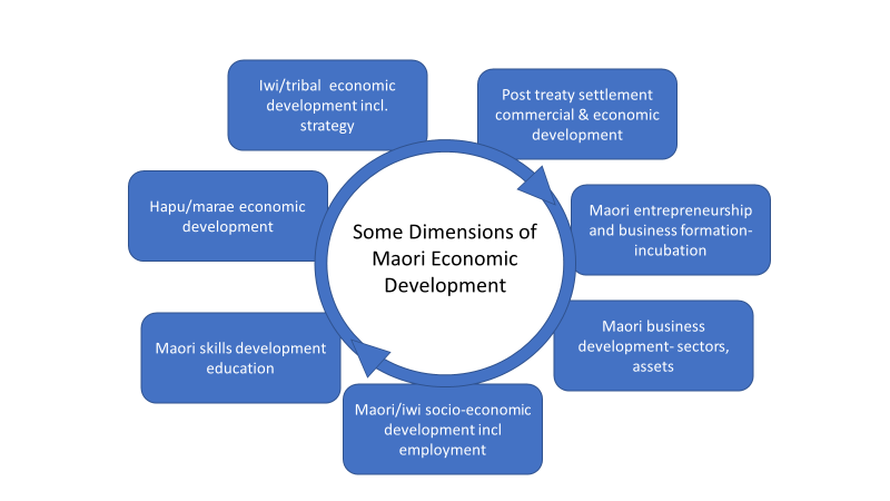
38
Figure 5. Some Dimensions of Māori Economic Development
61. The key role of Māori leadership in economic development was shown in Waikato Means Business and the
REDA Establishment governance through the appointment of some of the region’s key Māori and Māori
business leaders to the various steering groups, reference groups and boards which have been part of the
Waikato regional economic development process, including:
WMB Steering Group (2014-2018)
Traci Houpapa- Chair of Federation of Māori Authorities
Parekawhia McLean- Chair of Waikato Tainui
Donna Flavell – CEO of Waikato Tainui
Mike Pohio- consultant and former CEO of Tainui Group Holdings.
REDA Project Advisory Group (2017)
Steven Wilson – consultant and advisor.
REDA Reference Group and REDA Establishment Board (2017-2018)
Kim Hill- consultant and founder of Te Humeka Māori business network
Chris Joblin- Chief Executive of Tainui Group Holdings
Les Roa – Longveld Engineering and Advisory Group for Maori Economic Development Agenda and
Action Plan.
62. These leaders, appointed for their skills and experience as much as the entities they represented, have
made a significant positive contribution to regional economic development in the Waikato, alongside the
many Māori leaders who are also leading economic growth alongside these processes.
63. As mentioned above the REDA Board selection process is apolitical and is driven by the need for skilled
and experienced governors. There will be no sector or interest representatives on the Board, although
skill/experience in Māori economic development and business growth will be a key skill we will seek. As
shown above we have been very fortunate to have had such skilled Māori as part of the Waikato
economic governance process to date. Similarly, we fully expect many talented Māori business leaders to
be nominated for the REDA Board.
Māori Economic Development - Strategic Leadership
64. As part of the REDA development process, in late 2017 the chairs and/or Chief Executives of all the main
iwi in the Waikato were contacted by phone and letter. All confirmed an interest in the Waikato REDA and
a willingness to discuss further how to engage with and potentially partner with the REDA.
39
65. The REDA Establishment Board prefers to provide Māori with the opportunity to consider how they wish
to engage with the Waikato REDA, and to build a relationship build on shared agreement on how the
various elements of economic development (
Figure 5) are managed and where opportunities to partner
can be best taken. These discussions are best commenced at the strategic leadership level and from there
agreement can be formed at the operational level- which is the level at which the REDA will add value.
66. We are mindful that the Waikato Plan Leadership Group has recently appointed iwi representatives from
across the region, a move which we applaud. Given that we also see the Waikato Plan as where regional
economic development strategy is best held and developed, the most effective way to ensure that an
aligned, coordinated and integrated approach is taken on Māori economic development strategic
leadership to be part of the remit of the Waikato Plan Leadership Group, and for the REDA to partner with
Māori at the project specific level.
Establishment Plan 67. The establishment process key tasks and responsibilities are set out below by month:
March – Appointment of the Establishment Board. Appointment of an Interim Chief Executive.
Development of Trust Deed and Constitution.
April – Approval of the establishment process by Mayoral Forum. Establishment of the Trust,
Incorporation of the Company. Discussions begin with councils on Service Level Agreement.
May – Draft Business Plan prepared. Draft Service Level Agreement with Waikato councils.
Advertising and search process for the permanent Chief Executive position.
June – Design work and initial Business Plan (for 12 months) for REDA completed. Service Level
Agreement finalised with Waikato councils. Strategic priorities in the Business Plan and Service Level
Agreement approved by Waikato Plan Leadership Group.
July – Waikato REDA formally begins operations. Advertising and search process for Waikato REDA
Board. Interviews for Chief Executive role.
August – Chief Executive appointment decision made by Establishment Board. Short-listing of
potential candidates for Waikato REDA Board. Development of Waikato REDA services.
September – Chief Executive appointment announced. Waikato REDA Board candidates assessed,
and recommendations made. Report to the Waikato Plan Leadership Group on the establishment
process, recommendations for Waikato REDA Board, and next six months of activity.
October – Waikato REDA Board established. Establishment Board dissolved.
From November – permanent Chief Executive commences.
Throughout this process, the Interim Chief Executive and his support team will continue to engage
with the councils to confirm funding arrangements and the service level agreement; private sector and
non-local government organisations to confirm funding arrangements; and iwi to determine the
agency’s role in delivering economic development services to Māori.
Waikato Economic Summit 68. The creation of the Waikato REDA creates a significant opportunity to bring together the region around a
common agenda for economic development, and importantly to agree on the pipeline of major projects
which will reach our economic objectives. These projects are likely to also be ones which the region seeks
government support for via the Tuawhenua Provincial Growth Fund.
69. In February the cabinet released a paper on the PFG which set out of the process for considering projects.
MBIE officials will explain this in more detail, however several criteria made clear the need for regional
support for projects before they will receive government support. Amongst these are criteria which
require:
“Evidence of relevant regional and local support, either through existing regional development
mechanisms, or through another relevant body such as a council, iwi or other representative group (or
reasons for any lack of local support)
Has been raised and discussed with the region’s economic development governance group”.
40
70. While the REDA will not operate as a regional funding gatekeeper, it will be committed to finding as many
ideas as possible to result in jobs and growth. It is also clear that in broad terms the Waikato REDA is going
to have a central role in this process, therefore we need to build the pipeline of agreed priority projects in
an efficient, joint and collaborative way, which strengthens and builds on the reason for, and purpose of
the Waikato REDA.
71. The first 1-3 months of the REDA will be crucial in terms of showing how action focused it is, and how well
it can show leadership in bringing all the different actors together to develop the pipeline of ideas and
actions the government (and the region itself) is asking for.
72. WMB and the REDA Establishment Board has given this some thought and considers that a soft start for
the REDA will fail to grasp the opportunity on offer. The REDA will need to mark its establishment in a
significant way which sees commitment to genuine action and which continues to support the one voice
principle of the Waikato Plan.
73. The REDA and the region needs to quickly identify and commit to a defined number of significant/high
impact projects that are of sufficient merit to win funding support from the PGF. But it also needs to be
inclusive and make sure that its focus is not only on “the usual suspects”- both in terms of projects and in
relation to the geography of those projects. The REDA is a “whole of Waikato” initiative and it needs to
demonstrate how it will do this.
74. In 2009 as the Global Financial Crisis started to affect jobs and wellbeing in New Zealand, the government
convened a Prime Ministerial Jobs Summit. The summit, held over several days in Auckland, brought
together the country’s key business, Māori, and political leaders to agree on the major actions which would
soften the impact of the GFC, ensure jobs were kept and, and the same time, seize some opportunities
which were otherwise not being taken. For a relatively new government and Prime Minister, it was also an
important act of leadership whose impact would be lasting. Some Waikato local authorities have also held
smaller scale economic summits (for example Waikato district) to inform their own economic development
strategies, and the learnings from these will be drawn upon.
75. Taking these as a model, the REDA Establishment Board will convene a Waikato Economic Summit to:
Show in a practical way the economic leadership role of the REDA
Build broad-based support for the REDA and show its capacity to get things going
Bring together all the various groups in the economic growth space and build a common/agreed
agenda of action for the whole region
Develop the pipeline of ideas and agree on those which should be presented to the PGF as:
o
Ready to go now - requests for operational and capital funding at both the small and large
scale
o
Validated concepts which need to be developed into investment proposals over the next 6-
12 months
o
Preliminary concepts – which need further concept development- and an agreement on how
to progress these.
76. The Cabinet paper stresses that the PGF can’t be used to fund existing projects, housing, waters
infrastructure, or projects which would happen anyway. It will also be essential that we keep focused on
supporting the programmes and action plans we already have as a region- including existing major
government investments and areas of focus (for example the Auckland-Hamilton Corridor) the Waikato
Māori Economic Development Action Plan and Agenda, major council projects, the existing Waikato
Innovation Park/NZTE/Callaghan projects and the WMB programme to name a few. We also need to
appropriately accommodate projects such as the Sub regional (southern) Waikato economic action plan
to ensure that the actions which emerge from them on a slightly different timeframe can be subsequently
accommodated into the pipeline.
41
77. The summit will need to be well planned for and executed, and to coincide with the formal launch period
for the REDA. Given the practicality of an event of this scale, the period August-September is considered
achievable. The venue is the Don Rowlands Centre, as it is centrally located and of the right size/layout.
Attendance is estimated at about 250 people but would vary across the 2 days.
78. The success of an event such as this depends on excellent project planning, the participation of the major
players and influencers in the region and outstanding event facilitation. It also requires a degree of pre-
event work to ensure that all participants are well briefed on the process and their role. All these matters
will be developed over the coming weeks and I will be seeking your advice and help to design the details
of the event. An event such as this will require dedicated resource and expertise to ensure it is a complete
success. A professional event manager and an outstanding facilitator will be sought for this event.
79. Initial “hold the date” notices have been sent by email to key ministers, Mayors and the Chair of the
Waikato Regional Council. Formal invitations will be sent in the next 1-2 weeks to all invitees.
Assessment of Significance
80. Having regard to the decision making provisions in the LGA 2002 and council’s Significance Policy, a
decision in accordance with the recommendations is not considered to have a high degree of significance
on the basis that this arises from national regulation which council is required to implement.
42
Report to Strategy and Policy Committee
Date:
11 June 2018
Author:
Mark Tamura, Manager Integration and Infrastructure
Authoriser:
Tracey May, Director Science and Strategy
Subject:
Regional growth management update
Section:
A (Committee has delegated authority to make a decision)
Purpose
1. To update the committee on key urban growth management activities within the Region.
Executive Summary
2. In response to significant population growth, particularly in North Waikato and the greater Hamilton
areas, the Waikato Regional Council (the Council) is involved in several significant and related growth
management projects.
3. This includes:
a. Updating the Future Proof Strategy in response to the National Policy Statement Urban
Development Capacity. This will, in turn, require changes to the Regional Policy Statement and
District Plans.
b. Planning for a potential interregional passenger rail service between Hamilton and Auckland. This
includes preparing strategic and detailed business cases for the consideration of the New Zealand
Transport Agency board.
c. Participation in the preparation of an Auckland to Hamilton corridor spatial plan.
4. These initiatives are progressing with urgency and in a collaboration with partner Councils, the
government and other agencies.
Staff Recommendations:
That the report
‘Regional Growth Management Update’ (Doc # 12603505 dated 11 June 2018) be
received.
Background
5. Recognition of the importance of coordinating land use planning and the provision of infrastructure
has led some councils experiencing growth pressures to work together on initiatives such as Future
Proof in Waikato and Smart Growth in the Bay of Plenty.
43
6. The draft Government Policy Statement on Land Transport and the announcement of Minister
Twyfords ‘urban growth agenda’ signal a significant shift in government expectations for integration
across land use planning and infrastructure investment. The urban growth agenda also suggests that
government will be more directly involved in spatial planning and coordination at a local level and has
an appetite for considerable reform.
7. The urgency of the councils involved, and the significant direct involvement of government agencies
in the work set out in this report, demonstrates a recognition of the importance of making timely
progress and also demonstrates the shift in government policy and priorities.
Issue
Future Proof
8. The Future Proof Strategy provides certainty over the broad location and timing of new development
within the high-growth sub-region. This enables partner councils and other agencies to plan their
investment in infrastructure to support growth.
9. On 24 May the council endorsed the first update to the Future Proof Strategy since 2009. This update
was the result of the first stage of a two-stage review of the Strategy and responds to changes to
national and sub-regional planning and local government. This includes the inclusion of the former
Franklin area into Waikato District and emerging cross-boundary issues, particularly with Auckland.
10. Stage two of the review is now underway. Importantly this will assist in meeting the requirements of
the National Policy Statement for Urban Development Capacity 2017 (NPSUDC).
11. This requires development capacity targets for housing to be set and to develop a Future
Development Strategy (FDS) that sets out the broad location and timing of new development capacity
and infrastructure.
12. The staff of Future Proof partner councils have recently agreed with the Ministry for Business
Innovation and Employment (MBIE) and Ministry for the Environment (MfE) the technical
methodology for determining current development capacity and therefore the method for setting
targets in accordance with the NPSUDC.
13. These targets and the consultation draft of the FDS are expected to be received by the Future Proof
Implementation Committee (FPIC) at their July meeting. The FDS will then be subject to the special
consultative procedure under the Local Government Act 2002.
14. The housing capacity targets are required to be incorporated into the Regional Policy Statement (RPS)
and relevant district plans without a Schedule 1 process by 31 December 2018.
15. The FDS is also required to be ‘produced’ by 31 December 2018. This will form a significant part of
stage two of the review of the Future Proof Strategy.
16. As the Regional Policy Statement currently contains significant detail on the location and timing of
development within the Future Proof area, it is expected that some further amendments to the RPS
and affected district plans will be required to ensure alignment. The nature of these potential changes
and process for update the RPS and district plans are currently being determined.
44
Auckland to Hamilton Corridor Plan
17. The Auckland to Hamilton Corridor Spatial Plan (the Corridor Plan) is a government initiative being led
by the Ministry of Business Innovation and Employment. Benefits anticipated from the project
include:
Enhancing the quality of the built and natural environments and the vitality of Auckland and
Hamilton and the communities within the corridor
Improving housing affordability and choices
Improving access to employment, public services and amenities.
18. Drawing on the work undertaken in Auckland and the Waikato Region, including Future Proof and the
Auckland Plan, the Corridor Plan will integrate the work undertaken, identify any evidence gaps, and
will recommend an overarching plan for quality integrated development with the Corridor.
19. While the government recognises the Future Proof Strategy is a quality example of spatial planning
for high growth areas it is limited to the high growth sub-region with the Waikato regional boundary.
The benefit of the Auckland-Hamilton corridor work is that it is pan-regional spanning the governance
boundaries of regional councils.
20. The terms of reference for the Corridor Plan are nearing completion. In parallel, an extensive
information gathering exercise is being undertaken to compile all relevant strategies and plans, as
well as information of development opportunities and constraints, including environmental, natural
hazard and infrastructure constraints.
21. A Ministerial and Mayors and Chairs briefing is scheduled for 2-5 June, and the plan is expected to be
completed by October this year.
Hamilton to Auckland Transport Connections Strategic Business Case
22. At its 11 June meeting, the Regional Transport Committee endorsed the Hamilton to Auckland
Transport Connections Strategic Business Case (Doc # 12596668).
23. In recognition of the strong growth in the north Waikato and Auckland regions, the Waikato Regional
Transport Committee (RTC) at its meeting on 4 September 2017, agreed to undertake a Strategic
Business Case (SBC) to investigate transport connections between Hamilton and Auckland.
24. The purpose of the strategic business case is to outline the issues and problems related to growth and
transport connectivity between Hamilton and Auckland and to confirm if there is a case for investment
to improve transport connections.
25. An Auckland and Hamilton Transport Connections Working Party (the Working Party) was established
by the RTC to develop an SBC by May 2018. The Working Party includes representatives from Waikato
Regional Council, Hamilton City Council (HCC), Waikato District Council (WDC) Auckland Council,
Auckland Transport, KiwiRail and the NZ Transport Agency. Representatives from Treasury and the
Ministry of Transport are also in attendance at the Working Party meetings.
26. Following an Investment Logic Mapping (ILM) process in early 2018 and robust problem definition,
the Working Party and key stakeholders agreed that the benefits they are seeking are:
Improved productivity
Improved resilience, safety, quality of life and environmental outcomes for communities
45
Optimised performance of existing road and rail network.
27. The SBC has identified a number of opportunities and strategic responses to address the problems
identified. These have been addressed through four themes covering:
Inter-regional transport infrastructure and service improvements, including undertaking a
business case for an interim inter-regional passenger rail service between Hamilton to
Auckland leading on to implementation in the short term and planning for an express/fast
passenger rail service in the medium to longer term between the two cities
Coordination of inter-regional planning
Integration of funding system across modes and agencies
Improvement to cross-boundary governance and management structure.
28. In summary, the strategic business case has demonstrated that the transport connections between
Hamilton and Auckland are under pressure due to strong land use and transport growth (and
demand).
29. Following the RTCs endorsement of the SBC, it has been forwarded to NZTA for support/endorsement.
This will enable Waikato Regional Council to seek funding assistance from NZTA for undertaking the
detailed business case work on a Start-Up inter-regional passenger rail service.
Start-Up Inter-regional passenger rail Detailed Business Case
30. As discussed above, a Detailed Business case (DBC) on a Start-Up inter-regional passenger rail service
between Hamilton and Auckland has been initiated.
31. Partners in the DBC include Waikato Regional Council, Hamilton City Council, Waikato District Council
partnered by the Ministry of Transport, Auckland Council and Auckland Transport, the NZ Transport
Agency and KiwiRail.
32. The DBC is required to comply with the NZTA Business Case guidelines in order to obtain endorsement
from NZTA Board so that the start-up passenger rail project can be included for funding in the 2018-
21 NLTP.
33. An Officials Group has been established to oversee the development of DBC. This Group comprises
staff from WRC, HCC, WDC, Auckland Transport, NZTA, KiwiRail and MoT. This group has been tasked
with making recommendations to scope out the basic service level and infrastructure standards and
to resolve any technical and operational issues that could undermine the successfully delivery of the
service.
34. It is intended that the Technical Governance Group will make recommendations to the Hamilton to
Auckland Transport Connections Working Party consisting of political representatives from WRC, HCC,
WDC and Auckland Council. Additionally, the Group will provide official endorsement of the DBC prior
to seeking WRC and NZTA endorsement.
35. The DBC to date has looked at:
The strategic context and case for establishing a passenger rail service
An assessment of the infrastructure required
Feasibility of existing station infrastructure and preferred station investment options
46
An assessment of the operation of the rail service
The preferred option for a passenger rail service
The economic case for the preferred option
The financial case to deliver a start-up inter-regional passenger rail service
The management case to deliver a start-up inter-regional rail service
Monitoring
Risks.
36. The Draft DBC was considered by the Start-Up Passenger Rail Working Group at their meeting on 11
May 2018. At this meeting the Working Group considered a timeframe put forward by NZTA which
outlined the SBC to be endorsed by July 2018 and the DBC endorsed by September or October 2018.
Assessment of Significance 37. Having regard to the decision making provisions in the LGA 2002 and Council’s Significance Policy, a
decision in accordance with the recommendations is not considered to have a high degree of
significance.
Legislative context 38. Planning and funding for land transport are governed by the Land Transport Management Act 2002.
This sets up the requirements and processes for preparing Regional Land Transport and Public
Transport Plans and manages government funding of the transport network.
39. Natural resource and land use planning, including the preparation and amendments of regional and
district plans is governed by the Resource Management Act 1991 (RMA). The NPSUDC is a government
policy statement prepared under the RMA to which the council must give effect.
40. Infrastructure funding, including the local share of transport infrastructure, is governed by the Local
Government Act 2002.
Policy Considerations 41. To the best of the writer’s knowledge, this decision is not significantly inconsistent with nor is
anticipated to have consequences that will be significantly inconsistent with any policy adopted by
this local authority or any plan required by the Local Government Act 2002 or any other enactment.
Conclusion 42. The management of growth in North Waikato is increasingly requiring inter-regional collaboration and
new ways of working with government agencies to progress shared priorities.
43. With a clear legislative mandate under the RMA for the coordination of land use and infrastructure,
and specific growth management functions under the NPSUDC, the Regional Council is increasingly
being looked to for leadership in these areas.
Attachments 1. Hamilton to Auckland Transport Connections Strategic Business Case (Doc # 12596668).
47
Strategic Business Case for
Transport Connections between
Hamilton and Auckland
Southern Motorway (peak-time 1963)
Southern Motorway (peak-time 2017)
Version 5 – 10 June 2018 (incorporating NZTA review)
Doc# 12596668
48
TABLE OF CONTENTS
........................................................................................................................................................................... 1
........................................................................................................................................................................... 1
Strategic Business Case for Transport Connections between Hamilton and Auckland .................................... 1
TABLE OF CONTENTS ..................................................................................................................................... 2
EXECUTIVE SUMMARY ................................................................................................................................... 4
PART A – THE STRATEGIC CASE ............................................................................................................. 8
1
Introduction ............................................................................................................................................... 8
2
Partners and key stakeholders .................................................................................................................. 9
3
Strategic assessment – outlining the need for investment ..................................................................... 11
3.1
Defining the key problems .............................................................................................................. 11
3.1.1
Problem 1 - A significant increase in demand for travel within the Hamilton-Auckland corridor,
driven by rapid growth, is reducing transport system levels of service and placing economic performance
at risk.
11
3.1.2
Problem 2 - Limited land use and transport integration across administrative boundaries is
reducing our ability to effectively manage growth impacts and achieve key growth-related objectives
12
3.1.3
Problem 3: Limited travel options in areas facing high growth is reducing liveability and
impacting on quality of life, safety and environmental outcomes ......................................................... 13
3.2
The benefits of investment.............................................................................................................. 14
The benefits that will potentially be achieved by successfully investing in addressing the identified problems
were proposed by the Working Party through a facilitated ILM workshop. These benefits have been
synthesised them into three key benefits with support of the facilitator, and then shared them with the
stakeholders for review. Consequently to the revision process being completed the Working Party agreed on
the following three benefits: ........................................................................................................................... 14
3.3
Key Performance Indicators (KPIs) .................................................................................................. 15
3.4
Drivers of Change ............................................................................................................................ 16
3.5
Status of the evidence base ............................................................................................................. 17
3.5.1
Population growth ................................................................................................................... 17
3.5.2
Land use ................................................................................................................................... 18
3.5.3
Economic growth ..................................................................................................................... 18
3.5.4
Transport ................................................................................................................................. 19
4
Strategic Context ..................................................................................................................................... 21
4.1
Relevant strategic documents and investments ............................................................................. 21
5
Conclusions and Next Steps ..................................................................................................................... 22
PART B ............................................................................................................................................................. 23
Potential opportunities and strategic responses ............................................................................................ 23
5.1
Theme one: Inter-regional transport and infrastructure improvements ........................................ 23
5.2
Theme two: Planning and technology frameworks ......................................................................... 24
5.3
Theme three: Funding approaches and systems ............................................................................. 24
5.4
Theme Four: Governance and management ................................................................................... 24
49
Background ................................................................................................................................................. 26
Purpose ....................................................................................................................................................... 26
Key Benefits ................................................................................................................................................ 26
Geographic Boundary ................................................................................................................................. 26
Scope ....................................................................................................................................................... 27
TIMEFRAMES ................................................................................................................................................... 27
Appendix 1 ....................................................................................................................................................... 28
o
Appendix 2 Status of the evidence base ............................................................................................ 29
Population growth .......................................................................................................................... 29
Land use .......................................................................................................................................... 29
Economic growth ............................................................................................................................ 29
Transport ......................................................................................................................................... 30
50
EXECUTIVE SUMMARY
This Hamilton to Auckland Transport Connections Strategic Business Case has been developed
collaboratively by Waikato Regional Council, Hamilton City Council, Auckland Council, Waikato District
Council, Auckland Transport, the NZ Transport Agency and KiwiRail. It has also been supported by Ministry
of Transport and Treasury.
Background and context
Auckland is facing rapid growth and struggling to meet the demands and expectations that entails.
At the same time, similarly rapid growth is happening in North Waikato (Pokeno, Tuakau, rural towns) and
Hamilton.
This rapid growth is having a number of flow on effects on transport outcomes, including lower levels of
service for road based trips (especially journey time reliability) and the ability to deliver appropriate mode
choices to provide real transport options and manage demand more sustainably.
There is a real risk that benefits delivered by the Waikato Expressway (Road of National Significance) and
other significant transport investments will be undermined by these impacts.
Most of these issues are already being considered through existing workstreams, however not the
transport connections and accessibility issues between Hamilton and Auckland, or across the regional
boundary. This strategic case looks at issues relating to travel between Hamilton and Auckland, as a key
strategic corridor, within the wider context above.
While there is a further need to resolve the wider corridor issues through a Transport Connections
programme business case (PBC), there is sufficient interest and potential value now in investigating a
Hamilton to Auckland passenger rail service through the development of a detailed business case (DBC)
Purpose and Strategic objectives
The purpose of the strategic business case is to outline the issues and problems related to growth and
transport connectivity between Hamilton and Auckland and to confirm if there is a case for investment to
improve transport connections.
There are a number of key strategic objectives already established by the partners involved, including (but
not limited to):
Supporting growth and affordable housing (Auckland Plan, Auckland Transport Alignment
Project, North Waikato Integrated Management Programme Business Case, and Future Proof)
Within urban areas, ensuring people have accessibility to goods, services and amenities
(Regional Land Transport Plans and Regional Public Transport Plans)
Improving transport safety in line with government objectives (Regional Road Safety
Strategies).
The strategic assessment in this strategic business case highlights problems and benefits that are well
aligned with these broader strategic objectives.
51
Problems & Benefits
Problem definition has been carried out by the partners following an Investment Logic Mapping (ILM)
process. The partners and stakeholders agreed the following problems exist in relation to the Hamilton to
Auckland Transport Corridor:
Problem 1:
A significant increase in demand for travel within the Hamilton-Auckland corridor,
driven by rapid growth, is reducing transport system levels of service and placing
economic performance at risk.
Problem 2:
Limited land use and transport integration across administrative boundaries is
reducing our ability to effectively manage growth impacts and achieve key
growth-related objectives
Problem 3:
Limited travel options in areas facing high growth is reducing liveability and
impacting on quality of life, safety and environmental outcomes
Arising from the problems identification it was determined that the key issues are:
Driven by the rapid pace and high levels of growth in population and related economic activity
Complex and affect multiple outcomes, requiring the efforts of multiple agencies to manage
Further complicated by the challenges in aligning and coordinating the efforts of multiple agencies
across administrative boundaries, including regional ones.
Benefits
As a result of the discussions, partners agreed through the ILM workshop that the benefits they are seeking
on the Hamilton to Auckland Transport Connections are:
Benefit 1:
Improved accessibility to goods, services, employment and amenities to enhance
interregional productivity (30%)
Benefit 2:
Improved resilience, safety, quality of life and environmental outcomes for
communities with a greater range of travel choices (40%)
Benefit 3:
Optimized performance of transport service levels across the existing road and rail
network (30%)
A particular concern identified here is that, for many communities located in the broader corridor between
Hamilton and Auckland, there are currently low levels of transport choice, as in many places the only
practical option available is use of a private vehicle. As communities continue to grow and essentially
become more urban in nature, this will in turn result in increased travel times, declining journey time
reliability and put liveability goals at risk.
If effective ways to address these drivers are not identified, it can be expected that transport outcomes will
worsen, evidenced by declining levels of service across the transport system in this area. It can also be
expected that this will impact on a wider range of outcomes relating to growth, liveability and housing
affordability and economic performance. Also at risk are the benefits that are being sought through major
transport investments including the Waikato Expressway and Southern Motorway improvements.
52
Key findings and Case for Change
This strategic business case highlights a series of gaps in strategic planning for an area that is facing one of
the highest levels of predicted growth in New Zealand over the next 30 years and beyond. In 2017 sub-
regional Waikato (Waipa, Waikato and Hamilton Council areas) and the Auckland region had an estimated
population of 1.9 million and Statistics NZ has provided a medium projected population of 2.7 million for
2043 (42% growth over that period). The gaps relate mainly to aligning planning between regions and
centres of high population growth, and include the priority problems indicated.
Some of these issues are already being addressed through existing workstreams, including the Supporting
Growth Programme Business Case and the North Waikato Integrated Growth Management PBC.
This strategic business case has looked carefully at the evidence that supports the problems identified
through the ILM process. Some of the key findings are:
•
Problem 1 is showing that there is strong growth in multidirectional annual average daily traffic
in the corridor at an interurban, inter-district and interregional level. This is affecting travel
time, economic efficiency and undermining productivity.
•
Problem 2 is depicting an historic disconnect in land and transport planning across the
Auckland and Waikato boundaries. Both regions have been very good at planning for growth
within their regions and following the legislative frameworks in place but there has been
limited work on spatial, housing, land use and transport planning across the regions.
•
Problem 3 is evidencing that a single modal focus on transport investment across the corridor,
is leading to limited travel options across the Hamilton to Auckland corridor and thus reducing
quality accessibility for disconnected communities, hindering quality of life and environmental
outcomes.
The consequences of not addressing the problems identified in this strategic case are expected to be large
and will significantly limit the ability of the agencies involved to achieve key strategic goals, especially those
relating to housing affordability, accessibility and safety. The predicted continuing decline in levels of
service should be expected to impact strongly on economic outcomes, as it becomes harder and more
time-consuming to access employment, goods and services.
Next Steps
More work is needed to fully understand the relationship of these two centres now and in the future, the
demands that will place on the transport system, and how those demands can best be addressed, as these
questions are beyond the scope of a strategic case to answer.
The complex and multi-faceted issues involved will require coordinated and aligned efforts to effectively
address the identified problems and achieved the investment objectives. A number of workstreams are
going to be commenced soon or are already under way. Key workstreams that have a strong association
with this SBC are:
•
The Hamilton to Auckland start-up passenger rail Detailed Business Case (lead by WRC/HCC and
including all Transport Connections partners)
•
Hamilton to Auckland Corridor Management Plan (lead by MBIE and NZTA)
•
Potential Transport Connections Programme Business Case (to be determined following the
completion of the Corridor Management Plan)
53
•
Future Proof Growth Strategy (Hamilton City Council, Waikato District Council, Waipa District
Council, Waikato Regional Council and NZTA)
•
North Waikato Integrated Growth Management Programme Business Case (Waikato DC, NZTA,
WRC and HCC)
•
Auckland Future Urban Land Supply Strategy (Auckland Transport, NZTA and Auckland
Transport)
•
Auckland Transport Alignment Plan (Auckland Transport, Auckland Council, NZTA and Ministry
of Transport).
•
Waikato Plan (Mayoral Forum)
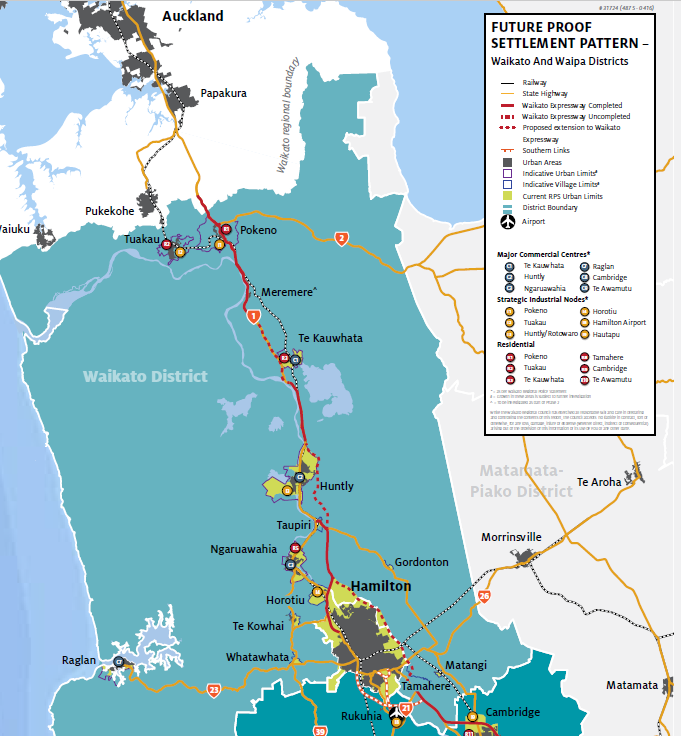
54
PART A – THE STRATEGIC CASE
1 Introduction
1.1. Background
The Waikato and Auckland regions are experiencing high population growth and this is expected to
continue. The majority of this growth has occurred in the past five years in Auckland, Hamilton and key
growth centres in northern Waikato communities along the corridor such as Pokeno and Tuakau. This
increasing growth will place significant pressure on the transport connections between Hamilton and
Auckland, and in particular State Highway 1 which is a nationally significant transport corridor that provides
strategic transport connections for the upper North Island. There is a real risk that benefits delivered by the
Waikato Expressway (Road of National Significance) and other significant investments will be undermined
by the impacts of continued growth.
In this strategic business case, the transport connections between Hamilton and Auckland include the local
authority areas of Hamilton City Council and Waikato District Council, through to the southern growth
areas of Auckland Council. The geographic spread of this area, and some of the key transport connections
between cities, towns and villages in this area are shown in Figure 1-1 below.
Figure 1.1: Transport connections, Greenfield areas, urban and residential areas between Hamilton and Auckland1
1 Visual sourced from Future Proof Strategy, 2017.
55
Auckland’s Transport for Urban Growth (TFUG), the North Waikato Integrated Growth Management
Strategy (NWIGMS) and Access Hamilton look to respond to the effects of growth on transport within each
studies area of assessment. However, there has not been a comprehensive assessment of the effect of
projected growth on the transport connections in and along the Hamilton – Auckland corridor as a whole.
In recognition of the need to plan for and respond to the pressure this growth places on the Hamilton-
Auckland corridor, and the importance of the area to upper North Island, the Waikato Regional Transport
Committee (Waikato RTC) in September 2017 agreed to undertake a strategic business case to investigate
the problems and opportunities related to transport connections between Hamilton and Auckland.
This Strategic Case looks at issues relating to travel between Hamilton and Auckland, as a key strategic
corridor, within the wider context above.
1.2. Purpose
This Strategic Case outlines the case for change by articulating the specific problems experienced now and
in the future by the community and stakeholders. It also provides information regarding the potential
benefits of investment and provides a recommendation to progress to address these problems with
partners and stakeholders.
The purpose of this Strategic Case is to bring together partners and stakeholders to confirm the issues and
opportunities related to growth and transport connectivity between Auckland and Hamilton and to confirm
if there is a case for investment to improve transport connections. The Strategic Case has followed the
principles of the NZ Transport Agency business case approach to:
Outline the high-level strategic framework, which incorporates key investment drivers, strategic
priorities from partners, as well as the work that is being undertaken, relevant to transport demand
and connectivity between Hamilton and Auckland.
Identify the key problems with respect to transport connections between Hamilton and Auckland,
and the potential benefits of addressing these problems.
Provide direction on potential interventions/opportunities to inform future transport/land use
planning work and business case investigations.
2 Partners and key stakeholders
The Waikato RTC established the Hamilton to Auckland Transport Connections Working Party (the Working
Party) to undertake this Strategic Case. Project partners were identified as organisations responsible for
influencing and/or managing land use and transport infrastructure in the subject area.
The Working Party includes representatives from Waikato Regional Council, Hamilton City Council, Waikato
District Council, Auckland Council, Auckland Transport, KiwiRail and the NZ Transport Agency.
Representatives from Treasury and the Ministry of Transport have also participated in the Strategic Case
development. Partners and stakeholders involved in this Strategic Case process are shown in Table 1.
56
Table 1: Strategic case partners and stakeholders
Partner/stakeholder Organisation
Role/responsibility in the context of this SBC
Partner
Hamilton City Council
Responsible for leading land use planning within
Hamilton City’s boundaries, and a key partner to
the central Waikato sub-regional growth
management framework (Future Proof). A road
controlling authority responsible for the
management and delivery of the local roading
network and public transport infrastructure in
Hamilton.
Partner
Waikato District Council
Responsible for land use planning within
Waikato district’s boundaries including the
North Waikato area. , A road controlling
authority responsible for the maintenance and
operation of the local road network within
Waikato district. A key partner to Future Proof
strategy.
Partner
Waikato Regional Council
Responsible for development and
implementation of the Regional Policy
Statement, Regional Land Transport Plan and
Regional Public Transport Plan. Also responsible
for the planning and delivery of public transport
services in the region. A key partner to Future
Proof strategy.
Partner
Auckland Council
Responsible for leading land use planning within
the Auckland region. It is responsible for
preparing the Auckland Unitary Plan, which is a
key mechanism for delivering the Auckland Plan
and enables growth to occur in a sustainable
manner.
Partner
Auckland Transport
Responsible for planning, delivering and
operation of transport infrastructure with the
Auckland region. This includes arterial and local
roads, public transport, pedestrian paths and
cycling facilities. Auckland Transport is also
responsible for planning and procuring public
transport services (buses, trains and ferries)
within the Auckland region. Auckland Transport
is also involved in projects focused on
sustainable behaviour changes such as
developing community and workplace travel
plans to encourage sustainable travel options.
Partner
NZ Transport Agency
Responsible for operating the State Highway
network that runs through the Waikato and
Auckland regions. It also co-invests with
Hamilton City Council, Auckland Council and
Waikato District Council for transport outcomes.
A key stakeholder in the Future Proof strategy
Partner
KiwiRail
A state-owned rail operator responsible for
operating freight trains nationally, and long
distance scenic trains such as the Northern
Explorer and TranzAlpine. In Auckland, the
57
Partner/stakeholder Organisation
Role/responsibility in the context of this SBC
metro train service is operated by TransDev,
and Auckland Transport contracts TransDev to
operate their commuter trains. KiwiRail owns
the rail track that is used by Auckland Transport
for their metro service, and provides access and
maintenance services.
Stakeholder
Ministry of Transport
Responsible for the Government Policy
Statement on Transport, investment signals and
setting transport rules and regulations.
Stakeholder
Treasury
Responsible for managing crown investment in
the transport sector, including funding for rail
asset maintenance and operations.
3 Strategic assessment – outlining the need for
investment
3.1 Defining the key problems
Facilitated investment logic mapping workshops were held on 22 November 2017, 19 December 2017 and 9
February 2018 with the key partners and stakeholders listed in Section 2, to gain a better understanding of
the current issues and needs. The partners and stakeholders identified and agreed the following key
problems:
Problem 1:
A significant increase in demand for travel within the Hamilton-Auckland corridor,
driven by rapid growth, is reducing transport system levels of service and placing
economic performance at risk.
Problem 2:
Limited land use and transport integration across administrative boundaries is reducing
our ability to effectively manage growth impacts and achieve key growth-related
objectives
Problem 3:
Limited travel options in areas facing high growth is reducing liveability and impacting
on quality of life, safety and environmental outcomes
The following sections review the evidence supporting the problems identified above.
3.1.1 Problem 1 - A significant increase in demand for travel within the Hamilton-
Auckland corridor, driven by rapid growth, is reducing transport system
levels of service and placing economic performance at risk.
A greater number of people are choosing to live in the upper North Island. Rapid population growth places
pressure on the transport system in a variety of ways:
A larger population leads to increased travel demand, placing pressure on existing networks which
can result in congestion, overcrowding and ultimately longer and less reliable travel times.
Increased travel demand can result in more impact from the transport system on people and the
environment, and greater conflict between movement and place outcomes on urban streets.
58
Traffic data illustrates that there has been a significant increase in traffic along the Auckland- Hamilton
corridor. It is expected, given the projected continuation of population growth, that traffic volumes will
continue to increase, exacerbating problems currently experienced and potentially compromising the
benefits delivered by the Waikato Expressway.
The amount of inter-regional commuting between Auckland and the Waikato has grown substantially as a
result of population growth and housing developments, and improvement on the state highways network.
This has led to an increase in demand for public transport and for state highway/local road intra and inter-
regionally. This will contribute to increasing peak journey times and congestion on the Hamilton to
Auckland corridor, and impact on sustainable growth and the liveability of cities/towns.
The pressure being placed on strategic transport infrastructure projects such as the Southern Motorway,
the Waikato Expressway and arterial roads is increasing as more Waikato and Auckland residents are using
the corridor to access employment, services, education and health amenities. It is important to note that
the full extent of the Expressway benefits won’t be realised until the project is completed in 2020
(construction of the Huntly and Hamilton sections are currently underway).
Investment in the Expressway of $2.4 billion is expected to decrease the travel time between Auckland and
Hamilton by over 20 minutes. Travel delays and poor reliability also risk undermining the investment
benefits from the Waikato Expressway. However, until that day, the existing demand and forecasted
growth will challenge the ability of the network to achieve safe and efficient accessibility, hampering
economic productivity.
3.1.2 Problem 2 - Limited land use and transport integration across
administrative boundaries is reducing our ability to effectively manage
growth impacts and achieve key growth-related objectives
The Hamilton – Auckland corridor traverses three local authority areas and whilst multiple projects have
been established to understand and respond to the impact of growth on the transport network within their
respective areas; integration of planning for land use and transport infrastructure across the corridor as a
whole has been limited.
There are no inter-regional policies or legally binding plans that facilitates the alignment of shared
outcomes across the regional boundary between Auckland and Waikato regions. The likelihood of
undermining existing strategic transport priorities and land development activities by taking a focus
delimited by geographical boundaries is a risk that is being exacerbated by the high growth witnessed
across Pukekohe, Tuakau and Pokeno, resulting in population centres getting closer to the boundary every
year. This means long-term strategies for regions such as Hamilton and Auckland are based on the growth
experienced or projected to occur within their geographical boundaries not across boundaries. This
exacerbates the inability of central agencies such as the NZ Transport Agency to implement cross-boundary
and inter-regionally significant policies to achieve integrated planning outcomes.
Regional Land Transport Plans (RLTP) and Regional Public Transport Plans (RPTP) prepared under the Land
Transport Management Act 2003 are not closely integrated with the Resource Management Act and Local
Government Act legislation, and the funding and planning system is horizontal rather than vertical.
Currently projects of inter-regional importance are identified in RLTPs following LTMA and LGA legislative
requirements. A number of factors exist which limit the ability to select the most effective and efficient
response. These factors include:
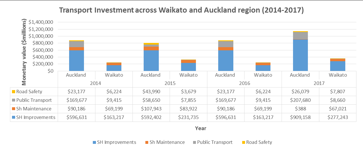
59
•
Funding and planning for road and rail are not fulling integrated under the current legislative and
funding framework (although this will change under the Government Policy Statement on Land
Transport v2.0)
•
Projects that have inter-regional objectives do not receive inter-regional funding support.
•
Shared funding is not achieved due to different funding focus (i.e. GPS, RLTPs and Long Term Plans).
•
Organisation budget constraints prohibiting implementation of some actions (i.e. KiwiRail has
significantly less budget and funding tools available to progress major infrastructure projects).
•
Requirement for both private and public funding to achieve greenfield development.
Historical funding has prioritised investment mainly in state highway and local road maintenance and
improvements over other activity classes such as public transport and road safety promotion (refer table
below). The investments for State Highway maintenance and improvements surpasses all funding classes
as it was approximately 85% of NZTA’s expenditure in Auckland in 2017 and a similar percentage for the
Waikato region. There has been significant investment in the Waikato Expressway project since 2009
onwards. However, transport classes such as public transport have received lower levels of funding.
In 2014 new rolling stock (Electrical Multiple Units) and train services were rolled out in the Auckland
network, however the expenditure on public transport was still only one third of the investment on State
Highway projects.
A focus on investment in local roads and state highway improvements has not placed an equal emphasis on
investment in other modes. This means investments in transport infrastructure has continued to prioritise
private vehicle and freight movements over other transport modes such as public transport, walking and
cycling, in addition with low financial support allocated to road safety.
3.1.3 Problem 3: Limited travel options in areas facing high growth is reducing
liveability and impacting on quality of life, safety and environmental
outcomes
Areas of Hamilton City and Waikato District have been developed that are predominantly car focused and
people use their cars for short trips as well as commuting. Public transport patronage is generally low in
areas where public transport is provided, and the Hamilton to Auckland transport corridor is not currently
well provided with suitable public transport options.
Currently there are limited transport options along the corridor and within the towns and villages that sit
within the corridor due to the low, dispersed population in the small towns, rural villages and townships. A
total of 78% of those that responded to the customer demand survey and live in Hamilton commute to
60
Auckland using a private car and only 5% use a commercial bus2. Thus it is clear that the preferred mode of
transport is by light commercial and private vehicles.
This shows is that commuters are choosing to commute using their car instead of bus services due to low
service levels being provided given that doesn’t meet customer expectations.
The fatal injury count has decreased on State Highway 1 between Hamilton and Auckland, but for serious
injuries the count has increased in the past 5 years. One of the main benefits that the improvement and
construction of the Expressway highlighted was a significant reduction in deaths and serious injuries.
The Waikato Expressway and Hamilton to Auckland corridor project is 9 years in and sections such as
Ngaruawahia, Cambridge, Rangiriri and Te Rapa have now been completed. However, serious injuries are
the highest than they have even been on SH1 for both the Southern Motorway and Expressway sections
over the past 9 years.
Lack of access to employment areas and workplaces will result in lower incomes received (possibly
unemployment) and a potential linkage to higher crime rates. Lack of travel choices across the corridor is
directly affecting people’s ability to access labour markets, quality education and proper healthcare. The
disconnection between communities is also being exacerbated by limited services that do not directly cater
for the growing road and public transport market, which has various needs that need to be directly
addressed if economic productivity and liveability across communities is to be improved. The optimised
usage of the transport corridor will provide numerous opportunities to access employment and services. It
will directly expand labour markets, lift household income and as a ripple effect, provide accessibility to
quality health and education services.
3.2 The benefits of investment
The benefits that will potentially be achieved by successfully investing in addressing the identified problems
were proposed by the Working Party through a facilitated ILM workshop. These benefits have been
synthesised them into three key benefits with support of the facilitator, and then shared them with the
stakeholders for review. Consequently to the revision process being completed the Working Party agreed
on the following three benefits:
Benefit one: Improved accessibility to goods, services, employment and amenities to
enhance interregional productivity (30%)
Benefit two: Improved resilience, safety, quality of life and environmental outcomes for
communities with a greater range of travel choices (40%)
Benefit three: Optimised performance of transport service levels across the existing road and
rail network (30%)
These benefits reflect the importance of understanding the connections required by communities; in
particular the broader objectives that can be achieved by providing a range of transport options to allow all
in the community to access employment, amenities and services.
Some of the main benefits derived from addressing the problems are:
Improved inter-regional commuting flows and overall network reliability.
Greater multimodal integration and planning for freight and passenger movements using both rail
and road corridors.
Provision of mode neutral transport solutions.
2 Customer Demand Survey, Mobius Research, 2018.
61
Ensuring effective, safe and reliable access to employment areas, affordable housing and
health/education services.
Increased freight productivity due to addressing travel times, cost of transportation and roading
conditions.
Improved alignment between land developers and regulatory authorities in the provision of utility
services and appropriate infrastructure for new urban areas (cross-regional significance).
Greater investment certainty for inter-regionally significant projects that require integrated
planning and inter-agency cooperation for successful delivery.
Increasing the existing travel options to directly reduces the number of private vehicles utilized
across the corridor
Progress towards a zero carbon emission network via a reduction of greenhouse emissions produced
by light and heavy vehicles.
3.3 Key Performance Indicators (KPIs)
A tentative list of indicators to measure the progress and status of the agreed benefits was reviewed by the
Working Party on 9 February 2018. These KPIs will be expanded in the subsequent business case stages,
where they will be developed with specific targets once detailed programmes are developed.
Table 1: Key Performance Indicators3
Benefit
KPI
Measure
Modal share
SOV share (JTW)
Improved accessibility
Congestion Index
to goods, services,
Traffic volumes
AADT/MADT SH1N count
employment and
Ratio of local versus out of region
amenities to enhance
Local economic performance
income
interregional
productivity (30%)
Employment rate
Travel time
Journey reliability
Average travel speed
Improved resilience,
Environmental sustainability
LV CO2 air emission load
safety, quality of life
Services accessibility
Stats-NZ transport access
and environmental
Deprivation Index (QoL)
MDI ranking
outcomes for
DSI crashes/traffic flow
communities with a
greater range of travel
Accidents
DSI
choices (40%)
Optimised
Rd/rail freight cost per km
Rai/road freight & passenger capacity
performance of
Road/rail freight ratio
transport service levels Returns from transport investments
Benefit/ratepayer cost ratio
across the existing
road and rail network
Transport service options
Inter-regional commuters by mode
(30%)
3 The broader benefit map including KPI’s, measures, descriptions, targets and baselines is yet to be finalised and will be completed during subsequent
business case processes.
62
3.4 Drivers of Change
The area under consideration of this SBC is the main transport corridor between the major urban areas of
Auckland and Hamilton (road and rail) set within the Upper North Island. Both metropolitan areas are
experiencing rapid growth, leading to rising housing prices and driving up transport demand. The area is
responsible for a significant portion of New Zealand’s economic output. The corridor plays an important role
in the upper North Island economy, particularly from a transport perspective, where road and rail, connect
Auckland with the Waikato, Bay of Plenty and rest of the country.
Increased transport demand is in turn affecting levels of service across the network, impacting liveability and
other outcomes. This includes rapidly increasing demand for commuter travel, mainly from Hamilton to
Auckland but some the other way.
The corridor is therefore being increasingly expected to fulfil roles as nationally-strategic freight, commercial
and tourism transport, regionally significant travel including commuting, and locally-important travel for a
wide range of purposes. The optimal performance of the transport connections between Hamilton and
Auckland is important to the New Zealand economy.
There is a need to more fully understand how these things work, so the corridor can continue to support the
overarching strategic objectives for Auckland, Hamilton and the northern Waikato region, which include
supporting the key objectives from the Auckland Plan, Transport for Future Urban Growth, North Waikato
Integrated Growth Management PBC and the Waikato Expressway.
To keep up with this economic growth, the connections between Hamilton and Auckland and the resiliency
of the transport network will be of critical importance. Additionally, new housing development across key
transport nodes and industrial locations will increase the volume of freight and the traffic flows inter and
intra-regionally through SH1N, SH2 and arterial roading.
Auckland and Hamilton are facing increasing housing prices and questions of affordability. The provision of
affordable housing particularly in Auckland has risen as a national issue and in June 2016 the Government
released the National Policy Statement on Urban Development Capacity. This in effect requires councils to
take steps to ensure sufficient land is provided for housing. Current and future urban areas need to be well
connected to employment, amenities and services to enable the growth of successful communities.
The majority of urban areas along the corridor, including Auckland and Hamilton are experiencing strong to
medium growth, this is leading to increasing housing prices and increasing transport demand. This demand
is in turn affecting levels of services across the network, impacting on liveability and other outcomes.
Population growth and rising housing prices are causing increases in transport demand including rapidly
increasing demand for commuter travel, mainly from Hamilton to Auckland, but also from and between
urban nodes along the corridor. The corridor is therefore being increasingly expected to fulfil roles as
nationally-strategic freight, commercial and tourism transport, regionally significant travel including
commuting, and locally-important travel for a wide range of purposes. The increasing demand by residents
to use the corridor, arterial roading and public transport across the wider network is putting substantial
pressure on the existing vehicle capacity that the infrastructure was designed for. This is leading to growth
in congestion, an increase in death and serious injuries, increase in travel times and a substantial increase
in greenhouse emissions produced by motorised vehicles. The declining levels of service across the
transport system impact on liveability (e.g. reliance on access to private vehicles, cost of transport and time
spent travelling to access key goods and services).
There is an increasing need to understand forward growth patterns and local, regional and interregional
transport movements of people and goods to ensure that the community is safe and part of a thriving and
liveable corridor. This has been recognised by the government who have recently commenced the Auckland
63
to Hamilton Corridor Management Plan project in partnership with local government and iwi. This project
looks to develop a spatial plan and associated implementation plan for the area around the Auckland –
Hamilton corridor. Objectives of the Auckland to Hamilton Corridor Plan are to:
Enhance the quality of the built environments and the vitality of Auckland and Hamilton and the
communities within the corridor
Improve housing affordability and choices
Improve access to employment, public services and amenities
Whilst several projects including Future Proof and the Auckland Development Strategy have incorporated
spatial plans, this Auckland – Hamilton Corridor Project aims to undertake this work as a true cross-boundary
project putting aside local authority boundaries. This spatial plan will be a key piece of information for the
design of detailed corridor transport connections.
In addition, the draft Government Policy Statement on Land Transport (GPS) was released in March 2018.
The GPS 2018 indicates a step change in the land transport system, with new strategic priorities and
amended objectives and themes. Of interest to this strategic case is the Government’s interest in transport
as lead infrastructure and enabling transport to support residential land developments, from planning
through to delivery.
The Government is committed to safety, liveable cities, regional economic development, protecting the
environment, mode neutrality, and to delivering the best possible value for money. The four strategic
priorities that the draft GPS 2018 focuses on are:
Safety
Access
Environment
Value for money.
The themes for the draft GPS 2018 are:
A mode-neutral approach to transport planning and investment decisions
Incorporating technology and innovation into the design and delivery of land transport investment
Integrating land use and transport planning and delivery.
These themes emphasis an increase in spending on public transport, walking and cycling, and new spending
on rapid transit. The Government wants to shift the emphasis in transport planning and investment from a
reliance on private, single occupancy vehicles to
“to deliver the transport system New Zealanders want – a
transport system that is safe, that allows New Zealanders to access opportunities and markets, and that
creates a healthy environment and health people.” The draft GPS also acknowledges the role of
interregional public transport.
As noted in the draft GPS, land use planning has a significant impact on transport planning, infrastructure
and services provision, and vice versa. This is important because the resident population of Auckland,
Hamilton and the Waikato district is projected to grow substantially over the next 30 years.
3.5 Status of the evidence base
A full outline of the evidence base is set out in Appendix 3 however a summary of key evidence is set out
below.
3.5.1 Population growth
Statistics New Zealand
64
•
In 2016, Statistics New Zealand estimated that 1.61 million people lived in Auckland while 160,000
people lived in Hamilton. The resident population of these cities has grown substantially over the last
16 years, by approximately 34 and 33 percent respectively.
•
Medium growth projections (2013 as base year to 2043) indicate that the resident population of
Auckland could grow to 2.32 million, while that of Hamilton could grow to a population of 224,800
people.
•
Waikato district will be home to an estimated 101,700
people and 65,900 people could live in Waipa
district.
•
The population of Tuakau is projected to increase by 39 percent
while
the population of Te Kauwhata
will more than double from their current size of 4,800 and 1,800 people respectively.
3.5.2 Land use
Auckland Unitary Plan
•
Approximately 15,000 hectares of mostly rural greenfield land has been identified in the Auckland
Unitary Plan (Operative in part). The majority of this land is in the South of Auckland, in areas such as
Pukekohe, Drury, Paerata, and Takanini.
•
The Southern Auckland
Growth area is expected to contain 42,000 new homes
and will require significant investment in transport infrastructure to support
this growth.
Future Proof Strategy
• In Hamilton greenfield land has been identified in Rototuna, Rotokauri, Ruakura, and Peacocke. These
greenfield areas are on the edges of Hamilton City and will provide infrastructure for the development of
approximately 9,600 new homes
.
• The low-medium projected demand for houses will range from 12,296 to 14,302 across Hamilton City over
the next 10 years.
• Waikato and Waipa district councils will experience a similar growth trend, with the total number of new
houses across the two districts ranging from 9,016 to 10,941 (low – medium).
3.5.3 Economic growth
Upper North Island
• Approximately 64 percent of New Zealand’s cargo by value is currently traded through sea ports in
Northland, Auckland and Tauranga, and inland ports in Auckland and the Waikato.
• Freight volumes are forecasted to increase by 59% by 2042.
• Heavy Vehicles kilometres travelled across the SH1N by Waikato and Auckland drivers has increased by
68 million across both regions from 2008 to 2017.
Cost of travel time delay for Waikato to Auckland traffic flow (Economic losses4
• The delays being experienced by transport system users in general, and commuters between Hamilton
and Auckland specifically, are significant, and growing.
• Travel Time Costs due to delay per journey by mode of transport across light vehicle drivers/passengers
traveling daily from Waikato to Auckland have been calculated at $172 million per annum.
4 The NZTA Economic Evaluation Manual provides behavioural values for travel time costs. The value for those commuting for work (once updated to
2017 and that use private car, commercial car or are passengers) is equivalent to $33.81 per hour. Same process applies for other journey
purposes.
65
3.5.4 Transport
Annual Average Daily Traffic Count and Vehicle Kilometres Travelled (NZTA) The number of residents that commute between Hamilton, the North
Waikato and South Auckland (through SH1N) on a daily basis to access
services and activities has grown from 26,026 (2011) to 32,726 (2017)
over the last five years (northbound and southbound aggregated) due
to economic and population growth, and investment in roading projects
such as the Southern Motorway improvements and the Waikato
Expressway.
•
Average Annual Daily Traffic (AADT) has increased considerably across all measurement points in
Southern and Central Auckland from 89,258 in 2012 to 98,027 in 2016.
•
The delay per kilometre across the Auckland network has changed from 37.8 to 45 seconds from
2012 to 2016.
•
Vehicles kilometres travelled by light vehicles across SH1 North by Waikato and Auckland residents
has increased by 276 and 814 million respectively from 2008 to 2017.
Road Corridor Improvements
Central Government has made significant investment in transport infrastructure in this transport
corridor to improve access to markets and road safety, and to enable economic growth. This
investment includes the building of the Waikato Expressway and the Southern Motorway.
Transport corridor improvements are continuing on the Southern Motorway, with the Southern
Corridor Improvements programme currently being undertaken by the NZ Transport Agency. This
covers the stretch of the Southern Motorway from the SH20/SH1 connection at Manukau down to
Papakura in the south. The completion of the Waikato Expressway is a key priority in the Waikato, to
the north and south of Hamilton City, along with improvement programmes such as Southern Links.
Growing inter-regional commuter flows
A key data source on commuting is the Statistic New Zealand Journey to Work data. In 2001, 990
people from the Waipa and Waikato districts and Hamilton City recorded in the Census that they
commuted to work in Auckland. By the 2013 Census, this number had grown to 6,737 residents (580
percent increase).
The largest growth in commuting was among private cars, trucks or vans, with 4,162 more residents
using these vehicles to commute to work in 2013 than 2001.
The number of Auckland residents commuting to Waikato for work in 2013 was equivalent to 2,5415.
In the context of the Hamilton – Auckland corridor, there is strong evidence established to show that
the impacts of growth on demand are not limited to inter-regional journeys. Key journey to work
numbers that evidence inter-district and inter-urban traffic across the corridor:
I. Residents in the Waikato District commute to Hamilton and Auckland for work, as shown in the
figure below. Pukekohe, South Auckland, Central Auckland are the top three destinations for
Waikato residents working in Auckland. By looking at the diagram below we can clearly see how
inter-district commuting from Waikato DC to Hamilton CC has increased considerably from 2006 to
2013.
II. Similarly Waikato residents are traveling daily in greater numbers to South Auckland, Pukekohe and
to central Auckland.
III. There were 345 residents from Huntly commuting daily to Hamilton for work in 2013, which is 195
more than in 2006 (150).
5 See detailed commuter flows by mode of transport and by year from Future Proof sub-region in Appendix X.

66
IV. 1,416 people that reside within Eureka, Gordonton, Tamahere, Matangi, Te kowhai, Ngaruawahia,
Horotiu and other areas (lower Waikato District) were commuting to Hamilton for work in 2013,
which is 975 more than in 2006 (441).
V. In 2013, 756 residents from Tuakau commuted to Auckland for work which is far greater than 2006,
when only 558 residents did the same journey daily.
VI. A household travel survey (2016) referenced in the transport assessment6 carried out for the North
Waikato PBC shows strong demand for travel locally to and from Pokeno and Tuakau, alongside
demand to and from Auckland, Hamilton and Pokeno.
Figure 3.2: Commuters from Waikato district to multiple destinations for work (2006 and 2013)7
Commuter travel time between Hamilton, Waikato DC, Waipa DC and Auckland
A customer demand survey has recently been undertaken by Mobius Research. This research obtained
an updated overview of commuter patterns and trends between Hamilton and Auckland.
Based on the survey findings, the average reported time to Auckland (Waitemata) is around 2 hours
and 1 minute, and the average peak journey time is about 2 hrs and 46 minutes for Hamilton residents.
For those living in Waikato District, the average journey time is 1 hr and 55 minutes and the average
peak journey time is 2 hrs an 48 minutes.
For Waipa District residents, the average journey time is 2 hours and 14 minutes and the average peak
journey time is equivalent to 3 hrs and 10 minutes.
Public Transport (North Waikato)
There are currently three bus routes operating within the North Waikato area:
-
Route 44: Hamilton – Pukekohe. Provides an inter-peak return trip between Hamilton and
Pukekohe. This service only operates every second Thursday.
-
Route 398: Tuakau – Pukekohe. Provides a daily commuter service departing Tuakau in the
morning and returning from Pukekohe in the evening. This service also provides an inter-peak
return trip on Wednesdays.
-
Route 399: Port Waikato – Pukekohe. Provides two inter-peak return trips between Pukekohe and
Port Waikato every Thursday.
Commercial bus services Two commercial bus operators, InterCity Group (NZ) Ltd and ManaBus.com, provide services between
Hamilton and Auckland and stop in some North Waikato communities. In summary, there are 21
commercial bus trips in each direction; 8 of these trips stop at Huntly and 10 at Pokeno. There are no
6
7 JTW data Stats NZ and related research reports, 2006-2013.

67
services that stop at Te Kauwhata or Meremere and there are no commercial services to Pukekohe,
Tuakau or Port Waikato.
Road Safety
The graph bellow shows the number of fatal and serious injury victims from crashes that occurred within
SH1N corridor between Hamilton and Auckland (2000-2017)
8
4 Strategic Context
4.1 Relevant strategic documents and investments
To successfully address the problems that have been identified as part of the investment logic map and
appropriately corroborated through the presentation of the evidence outlined above, it is important to
ensure that we thoroughly comprehend the goals and strategies sought by our key partners (outlined
previously in the document). This can be done by presenting a review of the key objectives outlined in
statutory plans and strategic documents.
These documents outline the policy priorities and projects of inter-regional significance across local and
central government. To effectively move forward to an investment stage, clear alignment of existing
funding and policy frameworks is of utmost importance. For a detailed overview of the documents outlined
above please refer to Appendix 3.
8 Death and Serious Injuries have been retrieved from NZTA’s Crash Analysis system, 2018.
68
5 Conclusions, Recommendations and Next Steps
Growth in Auckland, Hamilton and along the connecting corridor has been significant and this growth is
projected to continue. Transport links between Auckland and Hamilton are nationally and regionally
significant. A review of the evidence indicates that while several workstreams have been completed or
underway that consider the transport connections between Auckland and Hamilton, this work has not looked
at the corridor in its entirety.
Due to the location in the upper North Island and its proximity to Auckland / Tauranga (Golden Triangle)
ensuring strong and sustainable connections between Auckland and Hamilton is of national significance and
there is a case for change now.
The recently commenced Auckland to Hamilton Corridor Management Plan project will provide essential
information as to the long term future land use strategy for the corridor. The Auckland to Hamilton Corridor
Management Plan will provide in-depth detail and information regarding the key issues that adjoining urban
areas are facing from Hamilton to Auckland.
Following the completion of this Corridor Management Plan it is
recommended that a programme business
case be considered to investigate detailed transport connections between urban nodes along the corridor,
including long term planning for connections between the Auckland and Hamilton.
Significant investment has been made in recent years to improve the level of service provided by State
Highway 1, particularly through the development of the Waikato Expressway.
In recognition of the strong and continued population growth along the corridor combined with the change
in government direction through the GPS, it is also
recommended that a detailed business case is developed
that provide the scope and nature of a start up passenger rail service connecting Hamilton and Auckland.
The Hamilton to Auckland Transport Connections Working Party has presented a range of strategic responses
which require further investigation to be progressed into a programme of activities that can be implemented.
Further information is provided in the following Part B to this report.
69
PART B
Potential opportunities and strategic responses
During the development of the strategic business case the Working Group members workshopped
potential opportunities and strategic responses to the issues identified as part of developing the three
problem statements. These responses are expressed as ‘potential opportunities’ (or approaches) that could
be considered as part of future planning work and business case investigations. The strategic responses are
grouped under four themes that target the underlying cause of the problems identified rather than the
consequences.
•
Theme One:
Interregional Transport and Infrastructure Improvements
•
Theme Two:
Planning Frameworks
•
Theme Three: Funding Approaches
•
Theme Four: Governance and Management Systems
To successfully and effectively deliver transport related projects that take into account settlements
patterns, growth nodes and land use outcomes, local/regional Councils and investment partners need have
access to integrated and collaborative funding and planning frameworks underpinned by inter-regionally
integrated government and management systems.
Interregional commuter and traffic flow should ideally be addressed by Councils at each side of the
boundary through the provision of future proofed roading, transport infrastructure and Public Transport
Options. The uniqueness of each regional PT and roading network disincentives Councils to integrate and
provide services across the boundary. Alignment of local, regional and national priorities through the
establishment of a framework that has appropriate funding via NZTA to deliver the assigned transport
outcomes and supports the completion of high level business cases to deliver public goods to the necessary
growth areas.
5.1 Theme one: Inter-regional transport and infrastructure
improvements
The objective of this theme is to enable population and economic growth, while minimising the adverse
impacts of increasing traffic and congestion. The strategic responses/opportunities identified under this
theme focus on road and rail infrastructure and interregional public transport improvements that could
directly address the issue of network reliability, travel time and limited travel options, and these include:
Infrastructure improvement: Infrastructure investment is key to improving network capacity and
reliability to support future urban growth. Ensuring that investment alternatives are considered
across transport infrastructure that supports the usage of different modes is key to get the best
value for money, provide safe and efficient access to services and employment and promote
economic growth.
Demand Management: This is important to manage and reduce travel demand via road through
the corridor. It is recognised that commuter and traffic flows will increase in the future and supply
needs to be pre-emptive in supplying the right transport infrastructure and PT options to reduce
vehicle counts and increase patronage across mass transit options.
70
Public Transport: The strategic business case has identified that regional and inter-regional public
transport is critical to addressing the transport needs along the corridor. In general public
transport needs to be reliable, expedient, clean and safe. It has also been acknowledged that the
right level of service needs to be in place across key urban areas before population, traffic,
economic and housing growth takes place.
5.2 Theme two: Planning and technology frameworks
The objective of this theme is to identify potential areas in the planning field that can be improved to
support a more integrated approach for inter-regional transport and spatial planning.
Technology: The SBC has identified that the use of new technology is critical to addressing planning
problems on the corridor. The forecasted increase in electronic vehicle uptake, improvement in
smart application to plan journeys, increase in petrol prices and fabrication of fully autonomous
vehicles will change the infrastructure and roading engineering requirements through investment
across our network.
Planning Systems: The SBC has identified planning opportunities as key to addressing the problem
of historic lack of integration in planning systems across regional boundaries. The tangible
materialization of existing inter-regional strategies and plans must be assured for stakeholders to
continue to work collaboratively. Master planning of adjoin inter-regional areas which utilize
existing policy and strategic documents is key to successfully addressing upcoming population and
transport demand growth.
5.3 Theme three: Funding approaches and systems
The objective of this theme is to address existing funding frameworks and identify strategic
opportunities for improvements to funding systems.
Greater funding clarity: At present funding systems tend to allocate funding regionally and this
SBC has identified a strategic opportunity to seek greater certainty of projects of inter-regional
significance.
Funding needs to be sourced from multiple funds: The 2018 draft Government Policy
Statement on Land Transport has signalled new transport funding opportunities. Crown loans,
special appropriations and regional fuel taxes have been evaluated as potential funding sources
to increase the budget allocated for transport investment across different geographical layers.
The investigation of other financing tools such as development contributions, special purpose
funding mechanism, housing infrastructure fund, enhanced FAR, provincial growth fund etc.
Efficiencies can be gained: Successful integration between the Auckland and Hamilton Public
Transport and local roading network will have positive effects in terms of productivity, freight
performance and labour movement.
5.4 Theme Four: Governance and management
The objective of this theme is examine possible strategic opportunities to enhance existing governance
arrangements and management frameworks.
Successful collaborations: Successful collaborations between central and local government, and
develop these further to undertake specific initiatives of interregional significance.
71
Institutional change: Potential for a single agency such as the NZ Transport Agency co-ordinating all
transport modes including road and rail investment and funding streams.
A collaborative transport corridor entity: 30-year vision for the Hamilton to Auckland Corridor
agreed by all parties with a single corridor entity.
72
PART B (cont)
PROJECT PLAN FOR THE NEXT PHASE
Detailed Business Case for Hamilton to Auckland start up passenger rail
service
Background
Through the development of the Strategic Case the investment partners have agreed that there is a strong
enough strategic case to proceed to a Detailed Business Case for a Hamilton to Auckland start up
passenger rail service (DBC).
Purpose
The purpose of the next phase, the DBC on interregional passenger rail between Hamilton and Auckland, is
to complete a robust and detailed assessment of the costs, risks and benefits of the preferred option. This
will be done through the development of the following cases: Strategic, Management, Commercial,
Economic and Financial. The former will attempt to provide sufficient information and evidence to
determine whether the case can proceed for funding for implementation. A clear understanding of the
costs, benefits and disbenefits will be gained and clear linkages with the strategic framework will be made.
Key Benefits
As a result of the ILM workshops and facilitated discussions undertaken as part of the Strategic Case,
partners agreed that the benefits that they are seeking relate to improved quality of life across
communities by investing in transport activities that achieve value for money, optimize the use of existing
publicly owned assets, gives residents of the corridor a better range of travel choices and provide efficient
but safe access to employment and services between Hamilton and Auckland.
The benefits and corresponding weightings that were agreed and endorsed by the Working Party are the
following:
Benefit one: Improved accessibility to goods, services, employment and amenities to enhance
interregional productivity (30%)
Benefit two: Improved resilience, safety, quality of life and environmental outcomes for communities
with a greater range of travel choices (40%)
Benefit three: Optimised performance of transport service levels across the existing road and rail
network (30%)
Geographic Boundary
For the purpose of the Detailed Business Case, the key areas of interest will be Hamilton, Auckland and
urban areas that are adjoining or within proximity of the rail corridor between Hamilton and Auckland.
Direct beneficiaries of the preferred option are residents from Hamilton City and Auckland City together
with the Waikato DC urban areas from Pokeno, Tuakau, Te Kauwhata, Huntly, Ngaruawahia, Taupiri and
Horotiu.
73
Currently residents from sub-regional Waikato rely heavily on the state highway network (especially SH1) to
get to and from work in between towns, cities, districts and regions. Additionally, Hamilton City, Waikato
District and Waipa District’s residents commute multi-directionally to access work, housing, services and
education throughout the interregional corridor. Therefore most corridor residents will be within the
service zones of the inter-regional passenger rail service and as such are part of the geographical boundary
of interest.
Scope
The objectives of the Detailed Business Case are:
1. Ascertaining affordability, economic viability and funding of the preferred option (interregional
passenger rail service).
2. Identification of implementation and delivery risks, defining mitigations and contingencies to
ensure successful delivery of the investment.
3. Planning and project managing for successful delivery through the delivery of a robust
management case which identifies key delivery partners, their legal responsibilities and strategical
roles in delivery.
4. Providing sufficient evidence and information to allow the New Zealand Transport Agency Board to
make a decision to fund the implementation of the preferred option.
TIMEFRAMES
The DBC has taken approximately two months and three weeks to date and the expected completion time
for the full project is estimated to take approximately six months. However it is subject to funding partners,
governance group and the New Zealand Transport Agency endorsing the right documents at the estimated
dates and supporting the completion of the DBC.
A key milestone will be for the Final DBC to be endorsed by the Hamilton to Auckland Transport Connections
Working Party followed by the Regional Transport Committee, Hamilton City Council, the Waikato Regional
Council and the Waikato District Council by 30 September 2018. Consequently it is planned for the New
Zealand Transport Agency Board to to sign off the DBC at a Board meeting scheduled for between September
and October 2018.
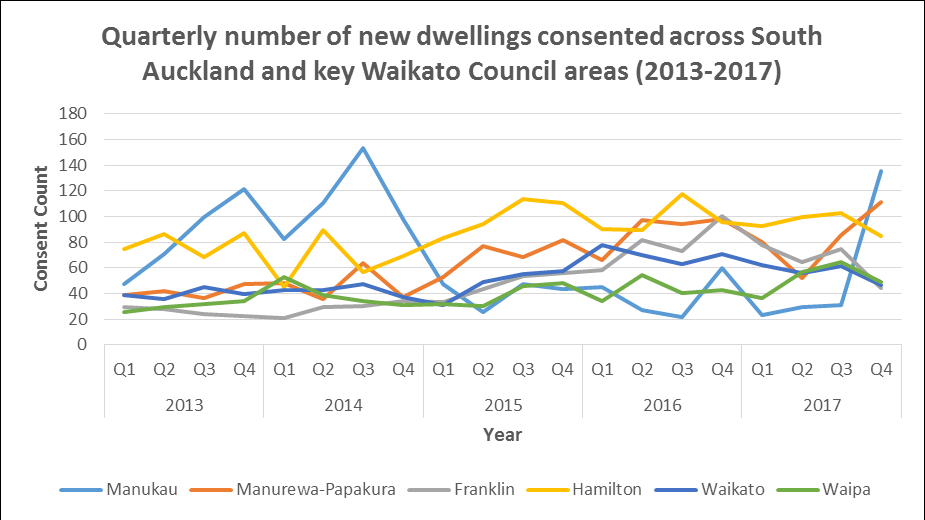
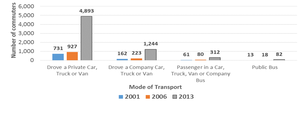
74
Appendix 1
Figure 3.1: Commuter flows by mode of transport from the Future Proof sub-region9 (Waikato, Hamilton and
Waipa) to Auckland region – Journey to Work data, 2001, 2006 and 2013
9 The concept of sub-regional Waikato refers to the Council Areas of Hamilton City, Waipa DC and Waikato DC. This term will be used throughout the
Strategic Case.


75
o
Appendix 2 Status of the evidence base
Population growth
Statistics New Zealand
•
In 2016, Statistics New Zealand estimated that 1.61 million people lived in Auckland while 160,000
people lived in Hamilton. The resident population of these cities has grown substantially over the last
16 years, by approximately 34 and 33 percent respectively.
•
Of out of the 400,000 new residents in Auckland region, 126,400 of them are located in South
Auckland. Across the Bombay’s, Waikato district has seen a population
rise of 17,700 and further South in Waipa district an increase of 11,800
throughout the same period.
•
Medium growth projections (2013 as base year to 2043) indicate that
the resident population of Auckland could grow to 2.32 million, while
that of Hamilton could grow to a population of 224,800 people.
•
Waikato district will be home to an estimated 101,700
people and
65,900 people could live in Waipa district.
•
The population of Tuakau is projected to increase by 39 percent
while
the population of Te Kauwhata will more than double from their current size of 4,800 and 1,800 people
respectively.
•
Since 2013, the number of new dwellings consented has increased significantly quarter-on-quarter
until the end of 2017 for Hamilton city, Waikato and Waipa district councils10.
Land use
Auckland Unitary Plan
•
Approximately 15,000 hectares of mostly rural greenfield land has been identified in the Auckland
Unitary Plan (Operative in part). The majority of this land is in the South of
Auckland, in areas such as Pukekohe, Drury, Paerata, and Takanini.
•
Southern Auckland
Growth area is expected to contain 42,000 new homes and
will require significant investment in transport infrastructure to support this
growth.
Future Proof Strategy
• In Hamilton greenfield land has been identified in Rototuna, Rotokauri, Ruakura, and Peacocke. These
greenfield areas are on the edges of Hamilton City and will provide infrastructure for the development of
approximately 9,600 new homes
.
• The low-medium projected demand for houses will range from 12,296 to 14,302 across Hamilton City over
the next 10 years.
• Waikato and Waipa district councils will experience a similar growth trend, with the total number of new
houses across the two districts ranging from 9,016 to 10,941 (low – medium).
Economic growth
Upper North Island
10 See appendix for detailed graph with historical trend of dwellings consented across the sub-region of Waikato and key Auckland locations.


76
• Approximately 64 percent of New Zealand’s cargo by value is currently traded
through sea ports in Northland, Auckland and Tauranga, and inland ports in Auckland
and the Waikato.
• In term of Gross Domestic Product (GDP), the UNI area (Bay of Plenty, Waikato,
Auckland and Northland regions), contributes 3.1 billion
through dairy products, 2.5 billion in food and beverage
cultivation, 2 billion via forestry and 4.4 billion with tourism
(6% of NZ’s total GDP).
• Freight volumes are forecasted to increase by 59% by 2042.
• Heavy Vehicles kilometres travelled across the SH1N by Waikato and Auckland
drivers has increased by 68 million across both regions from 2008 to 2017.
• The strategic importance of the Upper North Island to the New Zealand economy,
and the efficient movement of freight within and through this area, has been acknowledged by the
previous and current government. This acknowledgement is based on evidence developed by UNISA in
conjunction with Auckland Transport, KiwiRail and NZTA, on freight activity in the Upper North Island.
• In 2013, seven critical freight-related issues were identified in a UNISA study known as the Upper North
Island Freight Story. Two of these issues related to land, including an issue regarding the disconnection
between land use and transport planning and investment. This issue has recently been raised again in the
Draft Government Policy Statement on Land Transport 2018.
Cost of travel time delay for Waikato to Auckland traffic flow (Economic losses11
• The delays being experienced by transport system users in general, and commuters between Hamilton
and Auckland specifically, are significant, and growing.
• Travel Time Costs due to delay per journey by mode of transport across light vehicle drivers/passengers
traveling daily from Waikato to Auckland have been calculated at $172 million per annum.
Transport
Annual Average Daily Traffic Count and Vehicle Kilometres Travelled (NZTA) •
The number of residents that commute between Hamilton, the North
Waikato and South Auckland (through SH1N) on a daily basis to access
services and activities has grown from 26,026 (2011) to 32,726 (2017)
over the last five years (northbound and southbound aggregated) due
to economic and population growth, and investment in roading projects
such as the Southern Motorway improvements and the Waikato
Expressway.
•
Average Annual Daily Traffic (AADT) has increased considerably across all
measurement points in South and Central Auckland from 89,258 in 2012
to 98,027 in 2016.
•
The delay per kilometre across the Auckland network has changed from 37.8 to 45 seconds from
2012 to 2016.
•
Vehicles Kilometres Travelled by light vehicles across SH1N by Waikato and Auckland residents has
increased by 276 and 814 million respectively from 2008 to 2017.
Road Corridor Improvements
11 The NZTA Economic Evaluation Manual provides behavioural values for travel time costs. The value for those commuting for work (once updated
to 2017 and that use private car, commercial car or are passengers) is equivalent to $33.81 per hour. Same process applies for other journey
purposes.
77
The Government has made significant investment in transport infrastructure in this transport corridor
to improve access to markets and road safety, and to enable economic growth. This investment
includes the building of the Waikato Expressway and the Southern Motorway.
Transport corridor improvements are continuing on the Southern Motorway, with the Southern
Corridor Improvements programme currently being undertaken by the NZ Transport Agency. This
covers the stretch of the Southern Motorway from the SH20/SH1 connection at Manukau down to
Papakura in the south. The completion of the Waikato Expressway is a key priority in the Waikato, to
the north and south of Hamilton City, along with improvement programmes such as Southern Links.
However, concerns have been raised that the investment objectives and outcomes sought by these
land transport programmes may not be achieved due to higher than projected population growth and
land use changes. There has been a lack of integration between land use and transport planning,
particularly in new residential developments along the transport corridor. In these areas, private
vehicle usage is high and public transport options are limited. This has necessitated a rethink
regarding the current situation in regards to commuter flows and transport infrastructure.
Growing inter-regional commuter flows
A key data source on commuting is the Statistic New Zealand Journey to Work data. In 2001, 990
people from the Waipa and Waikato districts and Hamilton City recorded in the Census that they
commuted to work in Auckland. By the 2013 Census, this number had grown to 6,737 residents (580
percent increase).
The largest growth in commuting was among private cars, trucks or vans, with 4,162 more residents
using these vehicles to commute to work in 2013 than 2001.
The number of people that are passengers in private cars, trucks or vans has increased from 61 to 312
over the same period; but not at the same rate as single occupant private vehicle usage.
The number of Auckland residents commuting to Waikato for work in 2013 was equivalent to 2,54112.
We also know that the light vehicles from Auckland heading south over the regional boundary on SH1
is over 18,000, which means the share of work commuters is quite insignificant in comparison to non-
work commuters using the Auckland to Hamilton corridor.
The majority of these residents are commuting alone rather than as passengers in private vehicles,
with a smaller number using company vehicles.
In the context of the Hamilton – Auckland corridor, there is strong evidence established to show that
the impacts of growth on demand are not limited to inter-regional journeys. Key journey to work
numbers that evidence inter-district and inter-urban traffic across the corridor:
VII. Residents in the Waikato District commute to Hamilton and Auckland for work, as shown in the
figure below. Pukekohe, South Auckland, Central Auckland are the top three destinations for
Waikato residents working in Auckland. By looking at the diagram below we can clearly see how
inter-district commuting from Waikato DC to Hamilton CC has increased considerably from 2006 to
2013.
VIII. Similarly Waikato residents are traveling daily in greater numbers to South Auckland, Pukekohe and
to central Auckland.
IX. There were 345 residents from Huntly commuting daily to Hamilton for work in 2013, which is 195
more than in 2006 (150).
X. 1,416 people that reside within Eureka, Gordonton, Tamahere, Matangi, Te kowhai, Ngaruawahia,
Horotiu and other areas (lower Waikato District) were commuting to Hamilton for work in 2013,
which is 975 more than in 2006 (441).
XI. In 2013, 756 residents from Tuakau commuted to Auckland for work which is far greater than 2006,
when only 558 residents did the same journey daily.
12 See detailed commuter flows by mode of transport and by year from Future Proof sub-region in Appendix X.
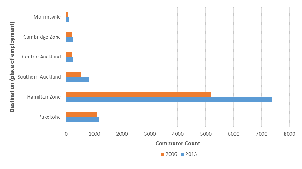
78
XII. A household travel survey (2016) referenced in the transport assessment13 carried out for the North
Waikato Programme Business Case shows strong demand for travel locally to and from Pokeno and
Tuakau, alongside demand to and from Auckland, Hamilton and Pokeno.
Figure 3.2: Commuters from Waikato district to multiple destinations for work (2006 and 2013)14
Commuter travel time between Hamilton, Waikato DC, Waipa DC and Auckland
A customer demand survey has recently been undertaken by Mobius Research. This research obtained
an updated overview of commuter patterns and trends between Hamilton and Auckland.
The tables below outline the reported travel time across 6 key destinations in Auckland by the survey
respondents from Waipa DC, Waikato DC and Hamilton CC. They were asked to report their maximum
peak time travel time, average travel time and minimum off-peak travel time.
Based on the survey findings, the average reported time to Auckland (Waitemata) is around 2 hours
and 1 minute, and the average peak journey time is about 2 hrs and 46 minutes for Hamilton residents.
For those living in Waikato, the average journey time is 1 hr and 55 minutes and the average peak
journey time is 2 hrs an 48 minutes.
For Waipa District residents, the average journey time is 2 hours and 14 minutes and the average peak
journey time is equivalent to 3 hrs and 10 minutes.
Origin Destination Travel Time matrix between HCC, Waikato DC, Waipa DC and Auckland (Customer
demand survey results)
Origin
Hamilton City Council
Waikato District Council
Waipa District Council
Off-
Off-
Off-
Average Peak
Average Peak
Average Peak
peak
peak
peak
Travel
Travel
Travel
Travel
Travel
Travel
Travel
Travel
Travel
time
Time
time
Time
time
Time
Final Destination
time
time
time
Devonport-
129
154
108
126
162
112
120
157
102
1 Takapuna
2 Waitemata
121
166
98
115
168
91
144
190
117
3 Albert-Eden
114
163
88
132
191
98
112
132
100
Maungakiekie-
107
143
91
97
150
76
132
197
118
4 Tamaki
13
14 JTW data Stats NZ and related research reports, 2006-2013.
79
Mangere-
106
143
88
94
143
74
133
161
116
5 Otahuhu
6 Papakura
95
117
83
79
95
65
Nil
120
Nil
These figures could be interpreted as most of the time commuters are taking 21 minutes longer than
the optimal travel time but when they commute at peak time, they can take as much as 1 hour and 6
minutes more than the ideal travel time.
The time spent in traffic is equivalent to monetary losses depending on the journey purpose. It is
known that a significant count of those commuting to Auckland from Hamilton and north Waikato and
vice-versa do it predominantly for work, those losses will be significant (base value per hour).
Public Transport (North Waikato)
The public transport services currently operating in North Waikato are shown in Figure 2.1. There are
three bus routes operating within the North Waikato area:
-
Route 44: Hamilton – Pukekohe. Provides an inter-peak return trip between Hamilton and
Pukekohe. This service only operates every second Thursday.
-
Route 398: Tuakau – Pukekohe. Provides a daily commuter service departing Tuakau in the
morning and returning from Pukekohe in the evening. This service also provides an inter-peak
return trip on Wednesdays.
-
Route 399: Port Waikato – Pukekohe. Provides two inter-peak return trips between Pukekohe and
Port Waikato every Thursday.
Route 398 has decreased substantially due change in service level by shortening the route to terminate
at Pukekohe instead of Papakura. The reduction of 65% and 36% in boardings across these two
services relates to people finding it more convenient, affordable and safer to travel with their private
vehicles rather than using any of the existing service provided by the Council. Additionally timetable
changes once getting to Pukekohe and also in Papakura deterred people from using route 398 and
399. By looking at the boardings per service km we can clearly see that the short distance service is
reduce total number of passengers but not the latter per kilometre travelled.
Tuakau and Port Waikato patronage data before and after Oct-2016 service changes
•
•
2015/16 (Dec-Feb)
•
2016/17 (Dec-Feb)
•
Change
r
r
r
r
r
r
s
e
e
s
e
e
e
e
gs
gs p
gs p
gs
gs p
gs p
gs
gs p
gs p
n
-km
n
n
-km
n
-km
n
n
-km
n
n
n
-km
•
Ro
ps
ps
oardi
rvice
oardi
oardi
rvice
oardi
rvice
oardi
oardi
rvice
oardi
oardi
oardi
rvice
ute
B
Tri
Se
B
trip
B
se
B
Tri
Se
B
trip
B
se
B
B
trip
B
se
Route 398
1,278
136
6,704
9.4
0.19
443
168
1,900
2.6
0.23
-65%
-72%
22%
Route 399
326
46
1,990
7.1
0.16
209
46
2,035
4.5
0.10
-36%
-36%
-37%
Route 44
298
12
1,189
24.8
0.25
213
12
1,189
17.8
0.18
-29%
-29%
-29%
•
Gra
1,902
194
9,882
9.8
0.19
865
226
5,125
3.8
0.17
-55%
-61%
-12%
nd Total
There is only one public bus that travels the route to Pukekohe from Hamilton and it does it only every
second week on a Thursday.
If you break down the annual boarding of service 398 by day, the service only gets 26 (13 each way)
passengers on-board per day (across two services). 2013 figures show that 411 residents from Tuakau
commute to Pukekohe for work. Thus only 3.1% of commuters are using the service. Thus the current
service level is declining and so is total boardings, which will result in lower farebox recovery and
greater local share required to keep the service operational. Lack of travel choices across the corridor
is directly affecting people’s ability to access labour markets, quality education and proper healthcare.
The disconnection between communities is also being exacerbated by limited services that do not
directly cater our growing road and PT market, which has variant needs that need to be directly
address if economic productivity and liveability across communities is to be improved.
80
Commercial bus services Two commercial bus operators, InterCity Group (NZ) Ltd and ManaBus.com, provide services between
Hamilton and Auckland and stop in some North Waikato communities. In summary, there are 21
commercial bus trips in each direction; 8 of these trips stop at Huntly and 10 at Pokeno. There are no
services that stop at Te Kauwhata or Meremere and there are no commercial services to Pukekohe,
Tuakau or Port Waikato.
The average standard ManaBus fare is around $12 but ranges between $10 and $16 and for Intercity
the average standard fare is around $19.50 but ranges between $12 and $30. Fares between
The commercial bus fares are not significantly higher than the current adult public transport fare on
route 44 between Hamilton and Pukekohe/Tuakau/Pokeno of $10.40 (Busit card) or $14.90 (cash) and
the Auckland Transport HOP fare from Pukekohe/Tuakau/Pokeno to Britomart is $7.50.
Cross Comparison across existing travel options between Hamilton and Auckland15
Mode of Transport
Limited Travel options (Hamilton to Auckland 2017)
Light Vehicles
Commercial bus
Average Travel Time(Peak-time)
146
144
Average Travel Cost (one-way)
$27.06
$15.75
Comparison
Daily People Flow Count (WAI-AKL)
16,411
875
Parameter
Passengers per vehicle (20 Bus
1.06
44
services a day)
Number of fatal and serious injury victims from crashes that occurred within SH1N corridor between
Hamilton and Auckland (2000-2017)16
Lack of transport access is impacting on quality of life •
To get an understanding of community development across townships, villages and urban areas of the
corridor, we will look at the New Zealand Multiple Deprivation Index17. This index is a proxy for
deprivation in terms of employment, income, crime, housing, health, education and access to services.
Areas are ranked from 1 (least deprived) to 5,958 (the most deprived)
18.
•
Figure 3.14, shows that for areas like Waikato District (which excludes Taranaki-King Country) there
are clear problems with employment, income, crime, health, education and access (over 3,000 in
deprivation ranking). Each parameter is closer to the upper limit of most deprived (5,958) areas rather
than closer to the lower limit of least deprived, like the urban area of Epsom (in Auckland).
15 Travel times and car running costs were retrieved from survey results. Daily flows were computed using modal share data from Stats NZ and cost
for commercial buses was retrieved from operators websites.
16 Death and Serious Injuries have been retrieved from NZTA’s Crash Analysis system, 2018.
17 , Calculated by the University of Auckland using data from Statistics NZ.
18 Statistics NZ and Auckland University, 2014.

81
•
Epsom can be used as a good example as it is an affluent area of Auckland which is recognised for having
high employment rates, high income earners, and good schooling and health services. Epsom is located
in a geographical area multiple access points and provides services at a short distance from people’s
residence.
Multiple Deprivation ranked score for by General Electorate
•
Other key districts of interest are
District, Hamilton to Auckland Corridor (2014 analysis of
Manukau East and Hamilton (East
Census stats)
and West). They all perform
better than Waikato in regards to
accessibility to basic services and
amenities. However, they have
performance scores above 3,000
for crime, education, health,
employment and income. 19
19 Each parameter studied in the multiple deprivation index is correlated with one another. Thus having poor access to basic services will yield poor
results in educational outcome and health indicators.
82
Appendix 3
The following table outlines relevant central and local government priorities and policies, as presented
through strategies and funding documents.
Document name
Key objectives or priorities
Influence/implications for SBC
National strategies and plans
National Land
The NLTP 2015-18 guides
The NLTP states that inter-regional journeys
Transport
investment decisions under
are critical to support exports, general
Programme (NLTP)
four themes: value for
freight and journeys made by tourists.
money; encouraging
economic growth and
The amount of inter-regional commuting
productivity; making
between Auckland and the Waikato has
journeys safer; shaping
grown substantially as a result of population
smart transport choices; and growth and housing developments.
effective and resilient
networks
This SBC identifies options that could
The NLTP 2018-21 is
provide the following benefits:
currently being drafted by
A safe journey.
the NZ Transport Agency.
An increase in the number of people
and volume of goods being moved.
Improved connections between
different transport modes to enable
seamless end-to-end journeys.
Reduce dtravel times between key
strategic centres and freight hubs
and ports.
Efficient land-use patterns that
enable transport choice and reduce
the need to travel to access jobs and
services.
Draft 2018-21
The Draft GPS has four
This SBC identifies options that could
Government Policy
strategic priorities: safety (is
provide the following benefits:
Statement on Land
a safe system, free of death
A transport corridor that supports
Transport (GPS)
and serious injury); access
regional development and wider
(provides increased access
environmental commitments such as
to economic and social
the Paris Agreement target of
opportunities, enables
reducing greenhouse gas emissions
transport choice and is
to 30% below 2005 levels by 2030.
resilient); environment
Safe, efficient, and resilient
(reduces the adverse effects
on the climate, local
transport connections.
environment and public
Transport options that provide a
health); value for money
range of benefits over the whole of
(delivers the right
life of the investment.
infrastructure and services
A greater focus on connections
to the right level at the best
between land use planning and
cost).
access to transport options.
The Draft GPS provides a
strong signal of government
83
support for investment in
inter-regional public
transport connections.
National Policy
The NPS-UDC directs local
Auckland, Hamilton city, and the Waikato
Statement for
authorities to provide
district are considered high growth areas.
Urban
sufficient development
Development
capacity in their resource
This SBC identifies options that could
Capacity (NPS-
management plans for
provide the following benefits:
UDC)
housing and business growth
Support for efficient land-use
to meet projected demand.
patterns that enable transport
choice and reduce the need to travel
to access jobs and services.
Reduced travel times between key
strategic centres and freight hubs
and ports.
Improved connections between
different transport modes to enable
seamless end-to-end journeys.
A safe journey.
Inter-regional and regional strategies and plans
Auckland Transport
High level agreement among The amount of inter-regional commuting
Alignment Project
key stakeholders on the
between Auckland and the Waikato has
(ATAP)
long-term strategic approach grown substantially as a result of population
to the development of
growth and housing developments.
Auckland’s transport system.
The ATAP is currently under
This SBC identifies options that could
review.
provide the following benefits:
Funding approaches and financing
tools that consider multiple sources.
Successful collaboration between
central and location government.
Improve connections between
different transport modes to enable
seamless end-to-end journeys.
Reduced travel times between key
strategic centres and freight hubs
and ports.
Efficient land-use patterns that
enable transport choice and reduce
the need to travel to access jobs and
services.
North Waikato
The NW PBC provides an
The recommended programme includes
Integrated Growth
agreed framework for
planning activities, infrastructure and
Management
integrated land use and
services based on a growing resident
Programme
infrastructure planning in
population in the North Waikato.
Business Case (NW
north Waikato area over the
PBC)
next 30 years.
The NW PBC
has identified that the road
The NW PBC has been
network in the northern Waikato is
developed concurrently with unusually dependent on SH1, which is used
84
the Future Proof Strategy
for both long distance trips (between
and Auckland’s Supporting
Auckland and Hamilton), and local trips
Growth initiatives
(between Pokeno and Huntly, Te Kauwhata
(previously Transport for
and Huntly etc.).
Urban Growth).
Currently 47% of trips from north Waikato
are destined for Auckland, compared with
16% destined for Pukekohe, but these
proportions may change over time. This is
important in a national context because of
its impact on the Auckland and Waikato as
two of the largest population and economic
centres.
This SBC identifies options that could
provide the following benefits:
Access to housing, particularly
affordable housing.
Access to services and employment.
Efficient land-use patterns that
enable transport choice and reduce
the need to travel to access jobs and
services.
Improve connections between
different transport modes to enable
seamless end-to-end journeys.
Future Proof
Future Proof is a growth and To manage growth and integrate land use
Growth Strategy
infrastructure planning
and infrastructure planning and funding
partnership between
across within the sub-region
Waikato District Council,
Hamilton City Council, Waipa
District Council, Waikato
Regional Council, New
Zealand Transport Agency
and Tangata Whenua.
Auckland Unitary
The Auckland Unitary Plan
In regards to transport, the objectives of the
Plan (operative in
Operative in Part gives
Auckland Unitary Plan Operative in Part is
Part)
direction about the location
that transport is effective, efficient and safe.
and timing of future growth
in Auckland and the
This SBC identifies options that could
necessary infrastructure to
provide the following benefits:
support this growth.
The Auckland Unitary Plan
Transport supports the movement of
Operative in Part focuses on
people, goods and services.
achieving six key outcomes,
Transport investment enables
one of which “access and
growth, and integrates with and
connectivity for everyone”
supports a quality compact urban
relates specifically to
form.
transport
Transport investment avoids,
remedies or mitigates adverse
effects on the quality of the
85
environment, and the health and
safety of people and communities.
Facilitates transport choices, and
enables accessibility and mobility for
all sectors of the community.
Transport infrastructure is planned,
funded and staged to integrate with
urban growth, and that land use
development reduces the rate of
growth in demand for private vehicle
trips.
Auckland Future
The Auckland Future Urban
Up to 70% of new dwellings will be built
Urban Land Supply
Land Supply Strategy
within the existing urban area, while the rest
Strategy (AFULSS)
provides direction on
will be greenfield.
population growth and
where land will be required. The Plan identifies approximately 15,000
hectares of rural land for future
urbanisation, with the potential to
accommodate approximately 137,000
dwellings.
This SBC identifies options that could
provide the following benefits:
Transport infrastructure is planned,
funded and staged to integrate with
urban growth, and that land use
development reduces the rate of
growth in demand for private vehicle
trips.
Access to housing, particularly
affordable housing.
Access to services and employment.
Efficient land-use patterns that
enable transport choice and reduce
the need to travel to access jobs and
services.
Improve connections between
different transport modes to enable
seamless end-to-end journeys.
Funding approaches and financing
tools that considers multiple
sources.
Successful collaboration between
central and location government.
Operative Waikato
The Waikato RLTP focuses
The land transport system is developed and
Regional Land
effort and investment in
managed within the context of collaborative
Transport Plan
three core areas: strategic
and integrated land use and transport
2015-45 (RLTP)
corridors and wider network
planning at sub-regional, regional and wider
connectivity improvements;
spatial scales.
road safety; and managing
86
demand and transport
Measure 2 in the Waikato Regional Land
choices.
Transport Plan states that transport partners
An update
to the Waikato are to implement integrated land use and
Regional Land Transport Plan transport measures as directed by the
2015-2045 is currently being Regional Policy Statement.
consulted on. The priorities
presented in this draft are: This SBC identifies options that could
strategic corridors; managing provide the following benefits:
growth; safety; maintaining
what we have; and access
Recognises the strategic importance
and mobility.
of the upper North Island.
Recognises the need to improve
road safety outcomes.
Recognises the need to provide
appropriate transport choices to
enable people and communities to
meet their social, economic and
cultural needs.
Recognises the need to manage
transport demand in urban areas to
assist in meeting the transport
objectives identified in the plan.
87
88
Report to Strategy and Policy Committee
Date:
26 June 2018
Author:
Andrew Tester, Senior Policy Advisor, Policy Implementation
Authoriser:
Tracey May, Director Science and Strategy
Update on applications to Hamilton City Council for Te Awa Lakes
Subject:
development
Section:
A (Committee has delegated authority to make decision)
Purpose
1. To update the Committee on developments regarding the Te Awa Lakes Plan Change to the Hamilton
City Council District Plan, and the Special Housing Area proposal for the same site which will be
considered by Hamilton City Council at its meeting on 26 June 2018.
Staff Recommendation:
That the report
“Update on applications to Hamilton City Council for Te Awa Lakes development” (Doc # 12602766 dated 26 June 2018) be received.
Executive summary
2. In November 2017 Council endorsed a submission to Proposed Private Plan Change 2(PPC2) to the
Hamilton City District Plan, known as the Te Awa Lakes plan change Concurrently lodged with the private
plan change was an application for two Special Housing Areas (SHAs) in the same location as PPPC2, one
being for 1000 residential dwelling units, the other for 100 residential dwelling units in a mixed use and
residential precinct. Council was neutral in regard to support or opposition of the plan change, as it was
considered that insufficient information had been provided in the application to enable a full assessment
of impacts.
3. The developer has been working through the process of securing additional information, including a
jointly commissioned report on the economic impacts of the proposal.
4. In late May the applicant requested that the hearing for PPPC2 be deferred until 2019, and as such WRC
work on PPPC2 has been put on hold.
5. The applicants, Perry Group Limited, have decided to progress through the SHA process. HCC will be
considering whether to recommend to the Minister of Building and Construction that the SHA be
approved or declined the SHA at its meeting on 26 June 2018.
6. The ability for Council to influence an outcome that is cognisant of the matters raised in our submission
is now somewhat limited. The benefits of the SHA process, as developed by government, are that the
formal RMA submission, hearing, decisions and appeal provisions do not exist. Following HCC holding a
hearing on 26 June 2018, where staff have 10 minutes to present, a recommendation will be made to the
Minister.
Doc # 12602766
89
Background
7. In late 2017 Hamilton City Council (HCC) received three applications related to a block of land owned by
Perry Group Ltd (Perry’s), located north of Hutchinson Road, between the Waikato Expressway and the
Waikato River. The land is currently zoned Te Rapa North Industrial Zone in the operative Hamilton City
District Plan and has been used previously for sand quarrying activities. The Waikato Regional Policy
Statement (RPS) and associated Future Proof Growth Strategy (Future Proof) identify Te Rapa North as
one of nine sub‐regional strategic industrial nodes and allocates a proportion of the sub‐region’s required
industrial land to be provided at that location in a staged release over a 50 year timeframe.
8. The two applications received by HCC were:
Private Plan Change 2 to the Hamilton City District Plan (PPPC2), which proposes to rezone the land
to enable a mix of activities, including tourism, recreation, residential and business
Applications for two Special Housing Areas (SHAs) in the same location as PPPC2, one being for 1000
residential dwelling units, the other for 100 residential dwelling units in a mixed use and residential
precinct.
9. A report was brought to Strategy and Policy Committee on 28 November 2017 to discuss councils’
submissions to PPPC2 and the SHAs which both contain the same key points related to:
RPS strategic direction, Future Proof land use pattern, and co‐ordinating development and
infrastructure
Reverse sensitivity
Transport, including public transport, walking and cycling, and the coordination of land use and
transport infrastructure
Hazards, including geo‐technical considerations
The management of alligator weed.
10. Following discussion at the Strategy and Policy Committee meeting, the two submissions were made on
29 November 2018.
An update on the submission process
11. Since the lodgement of submissions in November 2018, staff have been involved in ongoing discussions
regarding the site, considering both strategic issues, and other specific matters, such as management of
alligator weed. Overall, the matters identified in WRC’s submissions from November 2017 still apply to
the site and have not been resolved.
12. In late May the applicant requested that the hearing for PPPC2 be deferred until 2019, and as such WRC
work on PPPC2 has been put on hold.
13. The SHA process is continuing to proceed, with the two separate SHA applications combined into one in
March 2018. HCC will be considering whether to recommend to the Minister of Building and Construction
that the SHA be approved or declined the SHA at its meeting on 26 June 2018.
Consideration of the Special Housing Area
14. The Special Housing Areas Policy and the associated SHA legislation provide comparatively limited scope
to input into the decision‐making process compared to the Resource Management Act 1991 (RMA)
Schedule 1 Plan Change process, with no RMA style hearing, mediation or appeals process. Therefore
HCC’s 26 June 2018 meeting will be WRC’s key opportunity to provide a statement and evidence in person
regarding residential development of the Te Awa Lakes site, and will affect the content of PPPC2.
15. HCC will be making a decision on the SHA based on its Special Housing Areas Policy, which includes the
following related to strategic land use:
Doc # 12602766
Page 2
90
Locational considerations:
The extent to which the proposed SHA is consistent with Council’s strategic
land use planning. If inconsistent, the extent to which it may materially compromise or alter Council’s
strategic land use planning and the effects of that inconsistency including effects on planned and
existing infrastructure.
The Special Housing Area Policy also includes the provision for a ‘Developer Agreement’. This may be an
opportunity for effects based issues that concern WRC to be provided for as part of the SHA.
16. To help inform HCC’s decision‐making WRC’s presentation and evidence to HCC will focus on the
following strategic and effects based issues:
Strategic matters:
o Inconsistency with the Future Proof land use patterns and RPS –the proposed changes to
land use are not supported by robust and comprehensive evidence and are inconsistent with
the RPS (particularly Section 6
Built environment) and the land use pattern set out in the
Future proof Strategy agreed by partner councils which include HCC.
Significant deviations from agreed settlement patterns increases investment risk for
government and the private sector.
o Vision and Strategy for the Waikato River – stormwater from the site will enter the Waikato
River, potentially having impacts on water quality and adding to cumulative effects
downstream.
Effects based considerations:
o Alligator weed – alligator weed is listed as a progressive containment pest plan species in the
Waikato Regional Pest Management Plan 2014. The Te Awa Lakes site is subject to a
restricted place notice under the Biosecurity Act 1993, and as such there are certain
obligations for the land owner and developers. The presence of alligator weed may have an
impact in terms of the staging and timing of development of the site, given that a weed
management plan will need to be implemented.
o Public transport – the site’s isolation from existing and more established urban areas
suggests that it would be difficult to provide passenger transport facilities to reflect the
aspirations for growing passenger transport patronage.
17. A limited allotted timeframe has been provided for WRC to present (10 minutes), so the focus is narrower
than in our submission. No other Future Proof partners submitted on the SHA, however, WRC staff will
liaise with Future Proof partner staff to ensure our presentation details the most relevant regional
considerations.
Assessment of Significance 18. Having regard to the decision making provisions in the LGA 2002 and Council’s Significance Policy, a
decision in accordance with the recommendations is not considered to have a high degree of significance.
Legislative context 19. WRC made two submissions related to the site. The first was to HCC’s Private Plan Change 2 (Te Awa
Lakes), which was notified under the provisions of Schedule 1 of the Resource Management Act. As
noted, the hearing of the Private Plan Change is the next formal step in the process, and this has been
deferred until 2019. The other submission made by WRC was on the Special Housing Area, which has
been applied for in accordance with the Housing Accords and Special Housing Areas Act 2013.
Policy Considerations 20. To the best of the writer’s knowledge, this decision is not significantly inconsistent with nor is anticipated
to have consequences that will be significantly inconsistent with any policy adopted by this local authority
or any plan required by the Local Government Act 2002 or any other enactment.
Conclusion 21. There are a number of strategic and effects based considerations for development of the Te Awa Lakes
site. HCC’s consideration of the SHA on 26 June 2018 will be a key opportunity for WRC to ensure that
Doc # 12602766
Page 3
91
key regional considerations are presented to HCC to assist in their decision‐making to recommend to the
Minister of Building and Construction to approve or decline the SHA. Further updates on the Te Awa
Lakes site will be provided once HCC makes a decision on the SHA.
Attachments
1. Waikato Regional Council submission to the Te Awa Lakes Special Housing Area Proposal (Doc #
11484715).
Doc # 12602766
Page 4
92
Report to Strategy and Policy Committee
Date:
5 June 2018
Author:
Benjamin Bunting, Principal Advisor, Science and Strategy
Authoriser:
Tracey May, Director Science and Strategy
Update on Thames-Coromandel District Council and Hauraki District Council
Subject:
Mangrove Management Bill
Section:
A (Committee has delegated authority to make decision)
Purpose
1.
To update on the progress of the Thames-Coromandel District Council and Hauraki District Council
Mangrove Management Bill (‘Local Bill’).
2.
To seek approval from the Committee to provide responses to the matters raised by officials advising the
Select Committee considering the Local Bill.
Executive summary
3.
At its February 2018 meeting the Committee endorsed the Waikato Regional Council (WRC) submission
to the Thames-Coromandel District Council and Hauraki District Council Mangrove Management Bill.
Council’s position on the Local Bill is one of neutrality.
4.
The Parliamentary Select Committee considering the Local Bill has received submissions and convened a
public hearing in Thames. Government officials advising the Select Committee convened a meeting with
the district councils and WRC on 29 May 2018. Following that meeting the officials sought responses
from the councils on seven key matters as detailed in Table 1 of this report and discussed thereafter.
Councils’ statutory role in this process is one of a submitter.
5.
Staff recommendations to the Committee (detailed below) are to support the key matters identified with
the exception of Matter i) which seeks to introduce responsibilities for WRC to lead the preparation of
any mangrove management plan developed under the Local Bill. Staff support council participating in this
process but not to be the lead agency.
6.
Staff recommendation is that Matter i) not be supported on the basis that the intent of the Local Bill is to
establish a mangrove management regime independent of WRC involvement and to remove WRC
statutory decision making responsibilities for mangrove management in parts of the Thames-Coromandel
and Hauraki districts, and as such the process is better led by those agencies who will have ultimate
implementation responsibility.
Staff Recommendation:
1. That the report
‘Update on Thames-Coromandel District Council and Hauraki District Council Mangrove
Management Bill’ (Doc # 12582904 dated 5 June 2018) be received.
2. That the Committee approve the following WRC positions in to the key matters identified in the
following table by the officials advising the Governance and Administration Select Committee considering
the Local Bill
93
Matter No.
Matter detail (as worded by officials)
WRC position:
i
WRC be invited to join the district councils as jointly
Supported in part.
responsible for preparing a mangrove management
WRC participates in the
plan.
preparation of the management
plan but does not take a lead
role.
ii
That the mangrove management plan is prepared
Support.
under the Local Government Act 2002.
Consistent with WRC position
endorsed in WRC submission to
Local Bill.
iii
The mangrove management plan is designed to
Support.
address mangrove management in specific areas (i.e.
Whangamata) but would also need to be applicable to
other coastal areas as required.
iv
Introduce some for on ministerial oversight; i.e.
Support.
Minister for Conservation approval so to ensure the
mangroves plan is compliant with the New Zealand
Coastal Policy Statement.
v
Introduce a sunset clause to provide for the review of
Neutral.
the mangroves legislation (in 5 years) and/or lapsing.
So to constrain any damaging long term effect.
vi
Clarifying the relationship between the mangroves
Support. management plan prepared under the Bill and the RMA Consistent with WRC position
– so that a mangrove management plan could become endorsed in WRC submission to
part of the Regional Coastal Plan without unintended Local Bill.
effects that might impact on, or conflict with, statutory
functions.
vii
As part of the relationship with the RMA, avoiding
Support.
ability for Environment Court to review or override the
mangrove management plan.
3. That the Committee ask the Director Science and Strategy to provide a written response to the Select
Committee officials consistent with WRC position on matters i) – vii).
Previous reports and council position
7. At its February 2018 meeting the Committee endorsed a submission by WRC to the Thames-Coromandel
District Council and Hauraki District Council Mangrove Management Bill (Doc # 11775432 (Committee
report) and Doc # 11630356 (Council submission)).
8. Council’s position on the Local Bill is one of neutrality consistent with Committee recommendation
SPC17/59. The WRC submission on the Local Bill notes that:
a. Council supports the district councils’ intent through the Local Bill to improve the efficiency
and effectiveness of mangrove management by the district councils
b. Council holds a neutral position on retaining or removing mangroves and cannot form a
‘remove or retain’ position ahead of undertaking robust and inclusive consultation as part of
the Regional Coastal Plan review (noting mangroves is a prioritised topic to be addressed).
c. Council is strongly of the view that retention or removal of mangroves needs to be assessed
on a case by case basis, having regard to the individual circumstances and values of each
harbour and estuary as well as localised community views.
94
9. Since the introduction of the Local Bill in July 2017 WRC has paused its work on progressing the mangroves
topic as part of the Regional Coastal Plan review because a plan change outcome is likely to be actively
opposed by the district councils and aligned stakeholders, and could be removed by the Local Bill. Further
it was considered potentially confusing for local communities with dual processes occurring, one a Local
Bill before Parliament and the other a plan change.
Background
10. On 16 March 2018 the Parliament Governance and Administration Select Committee convened in Thames
to hear public submissions on the Local Bill. Some 40 submitters were heard with approximately 25 per
cent supporting the intent of the Local Bill, particularly its application to potentially improve the efficiency
and effectiveness of mangrove management at Whangamata.
11. The Select Committee received more than 170 written submissions – the majority opposing the Local Bill.
General themes from those opposing the Local Bill were:
a. The ecological value of mangroves in supporting biodiversity values
b. The role of mangroves in mitigating coastal erosion caused by waves, flooding and storm surge
c. Concerns that a Local Bill, if passed, could set a precedent for local resource management
matters being addressed outside of the existing resource management legislation.
12. Some submissions were highly critical of WRC, particularly in regard to the process, costs, time duration,
and mangrove removal methods as part of exercising the resource consents at Whangamata. Other
submissions praised the approach of WRC in that, through preparing, negotiating and exercising the
resource consents, adverse effects of mangrove removal had been largely avoided.
13. Following the hearing the Select Committee advised it would consider and scrutinise submissions ahead
of releasing its report on 22 June 2018.
Engagement with government officials
14. The Select Committee is advised on the Local Bill by officials from the Ministry for Environment and
Department of Internal Affairs.
15. At the direction of the Select Committee the officials convened the district councils and WRC on 29 May
2018 to discuss the range of options identified as:
a. Recommend the Local Bill as worded.
b. Recommend an amended Local Bill.
c. Examine processes available under the Resource Management Act (RMA) to amend the
mangroves provisions of the Waikato Regional Coastal Plan (RCP).
16. At the outset of the meeting district councils sought that the focus of discussions be on the Local Bill
options only – specifically an amended version of the Local Bill. In doing so they acknowledged the desire
for any mangrove management plan developed under the statutory provisions of a Local Bill to have some
formal relationship to the RMA through linkage to the Regional Coastal Plan and/or some form of
ministerial oversight noting the Minister of Conservation holds responsibilities for the coastal marine area.
17. The district councils also sought that, through amending the Local Bill, placing responsibilities on WRC in
leading preparation of any mangrove management plan, recognising the skills and expertise of WRC and
its statutory functions for managing effects of activities in the coastal marine area.
18. It was acknowledged that providing the local communities with certainty around how mangroves will be
managed is essential.
19. Officials recognise that the ‘best case scenario’ timeframes under a Local Bill or an RMA plan change
process would be similar and that the Select Committee remain open to considering RMA options.
95
20. Current resource consents held by WRC for mangrove removal in Whangamata will have been fully
discharged ahead of either ‘best case scenario’ timeframes.
Feedback sought by officials
21. Following the 29 May meeting officials have now sought feedback from the councils on the key matters
that may inform Select Committee thinking on an amended Local Bill option. These matters are detailed
in the table below.
Table 1: Matters identified by officials for council response
No.
Matters identified by officials for response:
i
WRC be invited to join the district councils as jointly responsible for preparing a mangrove
management plan.
ii
That the mangrove management plan is prepared under the Local Government Act 2002.
iii
The mangrove management plan is designed to address mangrove management in specific areas
(i.e. Whangamata) but would also need to be applicable to other coastal areas as required.
iv
Introduce some form of ministerial oversight; i.e. Minister for Conservation approval so to ensure
the mangroves plan is compliant with the New Zealand Coastal Policy Statement.
v
Introduce a sunset clause to provide for the review of the mangroves legislation (in 5 years) and/or
lapsing. So as to constrain any damaging long term effect.
vi
Clarifying the relationship between the mangroves management plan prepared under the Bill and
the RMA – so that a mangrove management plan could become part of the Regional Coastal Plan
without unintended effects that might impact on, or conflict with, statutory functions.
vii
As part of the relationship with the RMA, avoiding ability for Environment Court to review or
override the mangrove management plan.
22. Each matter in Table 1 is discussed below.
Matter i) - WRC be invited to join the district councils as jointly responsible for preparing a
mangrove management plan.
23. The district councils now invite WRC to join them, through an amended Local Bill, as a council jointly
responsible for preparing any mangrove management plan acknowledging that WRC has skills and
expertise to assist the preparation of a mangrove management plan.
24. The Local Bill was prepared by the district councils as a means to establish a mangrove management
regime independent of WRC involvement and to remove WRC statutory decision making responsibilities
for mangrove management in parts of, or all of, their districts. This intent was reiterated in the first reading
speech from the Local Bill sponsor, Coromandel MP Scott Simpson, following his introducing the Local Bill
to Parliament in July 2017.
25. Press releases on the Local Bill from MP Simpson’s office state:
“This is an important local initiative aimed at resolving the issue of mangrove management by allowing
Thames Coromandel and Hauraki District Councils to formulate their own management plans without
involving the Waikato Regional Council.” (22 February 2018)
26. The WRC submission on the Local Bill sought WRC representation on any mangrove management
committee formed to prepare a mangrove management plan under the Local Bill. This was on the basis
that WRC wishes to ensure its catchment management and statutory functions are not compromised
through a mangrove management plan and that any expertise and information held by WRC can be
effectively provided to the plan making committee.
27. Staff advice is that further elevation of WRC responsibility (beyond that sought it its submission) is not
warranted and, if WRC were to be ‘leading’ the development of a mangrove management plan, it would
potentially be viewed as problematic and counterproductive by those stakeholders with longstanding
96
mistrust and animosity towards WRC over management of mangroves, particularly at Whangamata, and
as voiced at the Select Committee hearing.
Matter ii) - That the mangrove management plan is prepared under the Local Government Act 2002.
28. The Local Bill as drafted proposes that a mangrove management plan be prepared under the ‘special
consultative procedure’ provisions of Section 83 of the Local Government Act 2002. The rationale for this
is to provide certainty through an expedited the planning process and limited appeal rights compared to
those available under the RMA.
29. The WRC submission did not challenge the use of Section 83 for the district councils to prepare and
approve a mangrove management plan. The WRC submission sought amended wording so that the plan
making committee must ‘consider’ the views expressed or received during the special consultative
procedure.
30. Staff advice is that use of the Local Government Act 2002 in this regard is supported.
Matter iii) - The mangrove management plan is designed to address mangrove management in
specific areas (i.e. Whangamata) but would also need to be applicable to other coastal areas as
required.
31. The preparation of mangrove management plans for specific areas where mangrove management
through existing processes continues to be problematic (e.g. Whangamata Harbour as noted by
submissions) would provide certainty for those communities and stakeholders.
32. Continued WRC work on developing and implementing harbour and catchment plans, and other sediment
management strategies, across the Coromandel has seen community agreement on how mangroves will
be managed in the catchment-wide context. WRC would be concerned if larger scale mangrove
management plans were proposed that might would unwind mangrove management approaches and
other catchment management initiatives already in place and agreed to by the community and
stakeholders.
33. Through its previous joint work in developing a district-wide mangrove seedling consent application in
2014 WRC and TCDC are aware that there a numerous iwi with harbour interests and views on mangrove
management. A site specific mangrove management plan would enable particular iwi views to be
collected, considered and incorporated more effectively that a larger scale plan.
34. Staff advice is that WRC seek that any mangrove management plans be site specific.
Matter iv) - Introduce some form of ministerial oversight; i.e. Minister for Conservation approval
so to ensure the mangroves plan is compliant with the New Zealand Coastal Policy Statement.
35. Ministerial oversight or ministerial approval of any mangrove management plan would give the
community confidence and certainty on where overall responsibility for activities under the Local Bill
rests.
36. Relevant ministers could be the Minister for Local Government (given the Local Bill proposes a mangrove
management plan be prepared under the Local Government Act 2002), or the Minister for Conservation
as minister responsible for resource management decisions in the coastal marine area.
37. If oversight or approval was to be with the Minister for Conservation then the New Zealand Coastal Policy
Statement (NZCPS) may provide an existing framework under which to prepare a mangrove management
plan and meet the district councils’ desires for a mangrove management plan to link to the RCP.
38. Staff advice is that WRC support some form of ministerial oversight and approval of any mangrove
management plan.
97
Matter v) - Introduce a sunset clause to provide for the review of the mangroves legislation (in 5
years) and/or lapsing. So to constrain any damaging long term effect.
39. The intent of inserting a sunset clause into the Local Bill is for the legislation to end or lapse after a
specified period. This was proposed by the officials presumably to constrain the extent of any ongoing
and unintended impacts of mangrove management activities under the Local Bill.
40. Staff advice is one of neutrality in that the rationale and inclusion of a sunset clause is a matter for the
Select Committee.
Matter vi) - Clarifying the relationship between the mangroves management plan prepared under
the Bill and the RMA – so that a mangrove management plan could become part of the Regional
Coastal Plan without unintended effects that might impact on, or conflict with, statutory functions.
41. The intent of this item was to enable any standalone mangrove management plan developed under the
Local Bill to be incorporated within the Regional Coastal Plan as a means to provide further certainty and
confidence to communities and stakeholders.
42. If the Local Bill was enacted, except for areas and activities provided for in a mangrove management plan,
WRC would retain statutory responsibilities under the RMA relating to other activities within the coastal
marine area. District councils and government agencies (e.g. Department of Conservation) also hold
statutory functions over activities in coastal areas and associated catchments.
43. The WRC submission highlighted a key concern that, without due consideration of the catchment system
and responsibilities of the various agencies, the management of mangroves as proposed under the Local
Bill has the potential for consequential and possibly unintended effects which may impact on, or conflict
with, other statutory functions of the regional and district councils, Department of Conservation and
others.
44. The provisions of the current RCP would require amending to enable a mangrove management plan to be
incorporated. Such an amendment would be a relatively straightforward noting that existing method
17.10.3 of the RCP already allows for the incorporation of standalone plans such as harbour and
catchment plans. The RMA provides for the inclusion of documents by reference in plans and proposed
plans in accordance with Part 3 of Schedule 1 to the RMA.
45. Staff advice supports the linking of a mangrove management back to the RCP. However, while the RCP
can clarify some statutory responsibilities (of WRC and others), WRC is strongly of the view that the Select
Committee provide clear guidance on where the scope of a mangrove management plan end and
responsibilities under the RCP begin.
Matter vii) - As part of the relationship with the RMA, avoiding ability for Environment Court to
review or override the mangrove management plan.
46. All councils are keen to provide certainty and confidence to communities and stakeholders on local
mangrove management. The councils acknowledge that, given the collective knowledge and expertise
available to prepare a mangrove management plan, and ministerial oversight proposed in Matter 4 above,
it would be unnecessary for the Environment Court to review or override a plan.
47. Officials note that there are existing RMA options that exclude Environment Court oversight, such as the
Streamlined Planning Process.
Next Steps
48. The Select Committee is expected to release its report on 22 June 2018 including recommendations on
whether or not the Local Bill should proceed further.
49. If the Local Bill does not proceed further staff will immediately recommence plan review work on the
mangroves topic within the Thames Coromandel and Hauraki districts including community engagement.
98
Assessment of Significance 50. Having regard to the decision making provisions in the LGA 2002 and Councils Significance Policy, a
decision in accordance with the recommendations is not considered to have a high degree of significance.
Legislative context 51. The Local Bill is a proposed law only. Should the Select Committee decide that progressing the Local Bill
is warranted, it must pass second and third readings in Parliament before it can be enacted.
Policy Considerations 52. To the best of the writer’s knowledge, this decision is not significantly inconsistent with nor is anticipated
to have consequences that will be significantly inconsistent with any policy adopted by this local authority
or any plan required by the Local Government Act 2002 or any other enactment.
Conclusion 53. Government officials advising the Select Committee considering the Thames-Coromandel District Council
and Hauraki District Council Mangrove Management Bill met with the district and regional councils on 29
May 2018. Following that meeting the officials sought responses from the councils on seven key matters
as detailed in Table 1 of this report.
54. Staff advice to the Committee is to support the key matters identified with the exception of Matter i)
which seeks to introduce responsibilities to WRC to jointly lead the preparation of any mangrove
management plan developed under the Local Bill consistent with WRC’s submission on the Bill, staff
recommend WRC participate in this processes, but does not lead.
55. The WRC position in this regard through its submission on the Local Bill was to seek representation on any
committee responsible for preparing a mangrove management plan.
56. Matter i) is supported in part, as the intent of the district councils through the Local Bill is to establish a
mangrove management regime independent of WRC involvement and to remove WRC statutory decision
making responsibilities for mangrove management in parts of their districts, it is recommended that WRC
participates in, but does not lead, this process.
Attachments 1. Committee report on the Waikato Regional Council submission to the Thames-Coromandel District Council
and Hauraki District Council Mangrove Management Bill (Doc # 11775432 and 11630356).
2. Thames-Coromandel District Council and Hauraki District Council Mangrove Management Bill
(Doc # 10609004).
References Media release from Office of Hon. Scott Simpson, Member of Parliament for Coromandel (22 February 2018):
https://scottsimpson.national.org.nz/mangrove_submitters_to_be_heard_in_thames
Local Bill first reading speech (9 August 2017):
https://www.parliament.nz/en/pb/hansard-debates/rhr/combined/HansDeb_20170809_20170809_28
99
Report to Strategy and Policy Committee
Date:
01 February 2018
Author:
Ben Bunting, Principal Advisor Science and Strategy
Authoriser:
Tracey May, Director Science and Strategy
Waikato Regional Council submission to the Thames-Coromandel District
Subject:
Council and Hauraki District Council Mangrove Management Bill
Section:
A (Committee has delegated authority to make decision)
Purpose
1. To seek approval from Committee on the content, and subsequent lodgement, of the Council’s submission
to the Thames-Coromandel District Council (TCDC) and Hauraki District Council (HDC) Mangrove
Management Bill.
Executive Summary
2. In late November 2017, the Parliament Governance and Administration Select Committee called for
submissions to the TCDC and HDC Mangrove Management Bill. The submission closing date is 23 February
2018.
3. The Local Bill, as currently worded, has implications and uncertainties for Council’s functions in the coastal
marine area.
4. Council supports the intent of the Bill to improve the efficiency and effectiveness of mangrove
management by the district councils.
5. Council’s submission on the Bill focusses on improving its workability, balance and fairness. It also seeks
clarity from the Select Committee on the implications the Local Bill has for regional council functions, and
on the district council’s responsibilities to avoid, remedy or mitigate adverse effects.
Staff Recommendations:
1. That the report ‘
Waikato Regional Council submission to the Thames-Coromandel District Council and
Hauraki District Council Mangrove Management Bill’ (Doc # 11775432 dated 1 February 2018) be received.
2. That Committee approve the “
Waikato Regional Council submission to the Thames-Coromandel District
Council and Hauraki District Council Mangrove Management Bill” (Doc # 11630356) for lodgement to the
Secretariat of the Parliament Governance and Administration Select Committee.
Previous reports
6. The Committee previously received a report on the Local Bill at its March 2017 meeting (Doc # 10092097), at
that meeting Committee recommended:
a. “THAT Council support Thames Coromandel District Council in their approach of seeking a Local Bill
for mangrove management.
b. THAT Council takes a neutral position in regard to the content of the Bill.
100
a. THAT Council and Thames Coromandel District Council continue to work cooperatively under the
Statement of Intent and requests that Thames Coromandel District Council keep Waikato Regional
Council informed of the progress of the proposed Local Bill on a regular basis.”
b. (SPC17/59)
7. The Bill had not yet been drafted at the time of that Committee recommendation.
Background
8. Management of mangroves as an issue has a long history on the Coromandel Peninsula. By way of brief
recent history:
a. Mangrove removal currently requires resource consent under the Waikato Regional Coastal Plan.
b. ICM Directorate holds resource consents for the removal of mangroves at Whangamata,
Wharekawa and Tairua. Completion of these works is scheduled for April 2019.
c. Exercise of these consents by Council has been challenging and, while the agreed consent
outcomes have been delivered, the level of amenity outcome desired by some parts of the
Whangamata community were not part of the agreed consent outcomes.
d. In May 2016, the Chief Executives of Waikato Regional Council (WRC) and TCDC signed a Statement
of Intent for collaborative mangroves management. This included reviewing, as a priority, the
mangrove management provisions of the Waikato Regional Coastal Plan to better facilitate
mangrove management.
e. In December 2016, WRC staff commenced a review of the mangrove management provisions of
the Regional Coastal Plan in accordance with the Statement of Intent (SOI), as part of the wider
Regional Coastal Plan Review. This work was well underway when, in March 2017, WRC became
aware of the intention of TCDC to prepare a mangrove management Bill as a means to facilitate
permissive mangrove removal. WRC was not consulted as part of the TCDC and HDC decision to
pursue a Local Bill as an option.
f. The Local Bill was introduced to the Parliament in early July 2017 by Coromandel MP Scott Simpson
(National) and passed its first reading in August 2017. As a consequence, WRC ‘paused’ the
planned stakeholder and community engagement as part of the Regional Coastal Plan review so
as to not distract the community from the Local Bill process and to avoid potentially unnecessary
investment while progress of the Local Bill continued. This action to pause the WRC work
programme was undertaken in agreement with TCDC through the Statement of Intent process.
g. In late November the Parliament Governance and Administration Select Committee called for
submissions on the Local Bill. The submission period closes on 23 February.
Issues
Overview of the Local Bill content
9. A copy of the Local Bill is at Attachment 2. The purpose of the Local Bill is to enable TCDC and HDC, either
separately or jointly, to remove mangroves from the coastal area and restore, protect and enhance
amenity values and/or ecosystems of the coastal area.
10. HDC’s interests in the Local Bill are focussed on the permissive maintenance dredging of streams and
channels that flow into the southern Firth of Thames.
11. The Local Bill provides both councils with the discretionary power to develop mangrove management plans
for specified parts of their area, subject to the provisions contained in the Bill. The mangrove management
plan, when adopted and operative, is the vehicle to achieve the purposes of the Local Bill. The Bill proposes
that a mangrove management plan details:
The mangrove management area. This may be site/location specific or apply to any area of public land
determined by the council.
Removal methods proposed to be used
Any rules and restrictions that should be applied to the management activity
Identification of any amenity values to be restored and/or ecosystems to be protected
A review mechanism to assess effectiveness of removal.
101
12. The council (TCDC or HDC) will establish a mangrove management committee (of the council) to prepare,
adopt and implement the mangrove management plan. The Local Bill proposes a mangrove management
committee contain at least one iwi representative.
13. The mangrove management committee must prepare a draft mangrove management plan which would
be subject to the Special Consultative Procedure (under Section 83 of the Local Government Act 2002)
before adoption. This procedure provides the opportunity for interested persons to present their views to
the council. While the committee must have regard to views expressed during the Special Consultative
Procedure, it is the final decision maker in finalising and approving the mangrove management plan. There
are no appeal rights under these provisions.
14. The Local Bill does not seek that the district councils endorse the final mangrove management plan by
decision to make it operative, but rather, the plan become operative when it is made publically available.
Implications of Local Bill (if enacted)
15. In exercising powers under the Local Bill, the two district councils would not have to comply with any other
existing laws which control mangrove management activities (including disposal activities) within areas
defined through mangrove management plans. This includes subservient planning documents developed
under the Resource Management Act 1991 (RMA), this would include the provisions of the Waikato
Regional Coastal Plan. The enactment of the Local Bill would potentially set a challenging legal precedent
for other discretionary activities usually subject to RMA provisions.
16. If the Local Bill was enacted, except as provided for in the Bill for mangrove management (as specified
through mangrove management plans), Council would continue to retain statutory responsibility under
the Resource Management Act 1991 (RMA) relating to all other activities within the Coastal Marine Area
(CMA), including discharges from land into the CMA.
17. A key concern for Council is that mangroves are part of a wider catchment ecosystem, and, without due
consideration of the catchment system the management of mangroves as proposed under the Local Bill
has the potential for consequential and possibly unintended effects which may impact on, or conflict with,
regional council functions.
Council position on the Local Bill
18. The management of mangroves has been a vexed issue for Council over the last decade. There are
divergent community views about the value of mangroves, approaches to mangrove management and the
outcomes sought. While Council staff have worked hard to ensure all views have been considered and
included in decision making around mangrove management, there are polarised and vocal views within
some parts of the Whangamata community which have, to a degree, had a bearing on the progress on the
mangrove management policy response.
19. The resource consent process which Council has undertaken on behalf of the community and TCDC has
been costly and has been at the expense of greater investment in land management practices to reduce
sedimentation. Sedimentation which has a strong correlation of catchment land management practices,
the main contributor to mangrove spread, in harbours and estuaries.
20. From a financial and political perspective Council supports the district councils’ intent through the Local
Bill to improve the efficiency and effectiveness of mangrove management by the district councils and to
enable the district councils to maintain areas previously cleared under the resource consent process.
21. Consistent with Committee recommendation SPC17/59 Council holds a neutral position on retaining or
removing mangroves. Council cannot form a ‘remove or retain’ position ahead of undertaking robust and
inclusive consultation on the mangroves topic as part of Regional Coastal Plan review.
102
22. Council is strongly of the view that retention or removal of mangroves needs to be assessed on a case by
case basis, having regard to the individual circumstances and values of each harbour and estuary as well
as the localised community views.
Key points of Council submission
23. The focus of the attached submission is to improve the mechanics and workability and balance of
mangrove management plans proposed under the Local Bill. Key points raised for the Select Committee
to consider in progressing the Local Bill include further information in regard to:
a) the full suite of values associated with mangroves when preparing and considering a mangrove
management plan
b) that implementation of mangrove removal under the local bill has the potential for consequential and
possibly unintended effects within the CMA that might impact on, or be in conflict with, regional
functions to manage effects in the CMA
c) district council responsibilities for the full costs of mangrove management activities
d) district council responsibilities for management of any adverse effects and remediation that might
result from mangrove removal activities, including costs
e) the composition of a mangrove management committee being representative of community
perspectives, including the regional council
f) the implications of activities or proposals sought under other legislation to be carried out in areas
subject to the Local Bill.
Next steps
24. On 29 March 2018 the Parliament Governance and Administration Select Committee intends to publish its
report and recommendation on whether or not the Bill should proceed further. The Select Committee
comprises eight members consisting of four National MPs and four Labour Party MPs.
25. If the Local Bill does not progress further Council staff will immediately recommence its Regional Coastal
Plan review work on the mangroves topic including community engagement.
26. If the Local Bill is successful the Regional Coastal Plan would need to be amended in accordance with the
enacted Bill.
Assessment of Significance
27. Having regard to the decision making provisions in the LGA 2002 and Councils Significance Policy, a decision
in accordance with the recommendations is not considered to have a high degree of significance.
Legislative context
28. The Local Bill is a proposed law only. Should the Select Committee decide progress of the Local Bill is
warranted it must pass a second and third reading in Parliament before enactment.
Policy Considerations
29. If the Local Bill does not progress further Council will immediately recommence its Regional Coastal Plan
review work on the mangroves topic including community engagement. To the best of the writer’s
knowledge, this decision is not significantly inconsistent with nor is anticipated to have consequences that
will be significantly inconsistent with any policy adopted by this local authority or any plan required by the
Local Government Act 2002 or any other enactment.
Conclusion
30. Council intends to submit to the Parliament Governance and Administration Select Committee on the TCDC
and HDC Mangrove Management Bill. A submission has been prepared (attached) for Committee
consideration. While supporting the district councils’ intent through the Local Bill, as currently structured
it has implications and uncertainties for Council’s regional functions in the coastal marine area.
103
31. Council’s submission on the Local Bill focusses on improving its workability, as well as seeking clarity on
regional council functions, the district councils’ responsibilities to avoid, remedy or mitigate adverse
effects and the costs associated with this.
Attachments
1. Thames-Coromandel District Council and Hauraki District Council Mangrove Management Bill (Doc #
10609004).
2. Waikato Regional Council submission to the Thames-Coromandel District Council and Hauraki District
Council Mangrove Management Bill (Doc # 11630356).

104
File No:
22 12 05
Document No:
11630356
Enquiries to:
Tracey May
20 February 2018
Committee Secretariat
Governance and Administration Select Committee
Parliament Buildings
WELLINGTON 6160
Email:
[email address]
Dear Sir/Madam
Waikato Regional Council Submission to the Thames–Coromandel District Council and Hauraki
District Council Mangrove Management Bill
Thank you for the opportunity to make a submission on the “Thames–Coromandel District Council and
Hauraki District Council Mangrove Management Bill.” Attached is Waikato Regional Council’s
submission in regard to this document. This submission was formally endorsed by the Council’s
Strategy and Policy Committee under delegated authority on 13 February 2018.
Waikato Regional Council looks forward to being involved in further discussions regarding the
development of the Bill.
Should you have any queries regarding the content of this document please contact Tracey May,
Director Science and Strategy, on (07) 859 2748 or by em
ail [email address]
Regards
Tracey May
Director Science and Strategy
105
Submission from Waikato Regional Council on the Thames–
Coromandel District Council and Hauraki District Council Mangrove
Management Bill
Introduction and context 1.1
Waikato Regional Council (‘Council’) appreciates the opportunity to make a submission on the
Thames–Coromandel District Council and Hauraki District Council Mangrove Management Bill.
1.2
Mangroves are a native plant species and a valuable part of some coastal ecosystems in the
Thames-Coromandel and Hauraki districts. Mangroves also perform an important role in
trapping sediment and contaminants and in mitigating coastal erosion in some coastal areas.
1.3
Historically, changes in land uses surrounding harbours and estuaries where mangroves were
present has resulted in increased sediment entering these areas, which in turn has created
ideal conditions for mangroves to spread. Aerial photo records show that much of this
expansion occurred from the 1940s to 1970s.
1.4
Other activities in the coastal marine area (CMA), such as dredging, reclamations, construction
of marinas, causeways, roads, and urbanisation, has facilitated mangrove expansion through
accelerated sedimentation and disruption to natural coastal processes which previously may
have redistributed and removed sediment.
Concerns about mangroves
1.5
While there are divergent community views about the value of mangroves and approaches to
mangrove management, the spread of mangroves is causing concern to some people in some
communities in the Thames-Coromandel and Hauraki districts. Particular concerns relate to
mangroves altering the natural character, landscape and amenity values of an area.
1.6
Concerns are most prevalent in urbanised areas that border or overlook harbours and
estuaries where mangroves are present, in particular where those longstanding residents have
witnessed mangrove spread.
1.7
In addition to amenity values being reduced, mangrove spread may have adverse effects on
public access, navigation and the ongoing use and function of coastal structures and
infrastructure.
1.8
In response to the concerns noted above, Council acknowledges that some parts of some
communities seek more permissive mangrove removal. Council’s statutory responsibilities
around such decisions include considering the potential adverse effects of mangrove removal.
These effects may vary depending on the location, scale and method of removal and values
present and is not limited to:
a) disturbance and damage the foreshore and seabed
b) adverse effects on water quality from the release of sediment and contaminants
c) adverse effects ecological values, including bird species, particularly during breeding
and feeding
d) adverse effects to wider ecosystem services provided by mangroves
e) exacerbating coastal erosion where mangroves previously acted as a buffer or diffuser
of wave energy.
106
Council actions to manage mangroves
1.9
Mangrove removal currently requires resource consent under the Waikato Regional Coastal
Plan. The Regional Coastal Plan was developed in mid-1990’s when the then New Zealand
Coastal Policy Statement (1994) specified that a coastal plan include provisions for mangrove
management. The Resource Management Act 1991 (RMA), the New Zealand Coastal Policy
Statement and the Waikato Regional Coastal Plan recognise the CMA is a public asset and
mangrove management activities may be undertaken for public purposes.
1.10
Council has always sought to engage with its communities in regard to how mangroves may
be managed and, through its harbour and catchment management activities, has focussed on
the cause, that is to promote land use activities that lead to reducing sediment from entering
the CMA.
1.11
From 2008–2012 Council worked closely with the Whangamata, Wharekawa and Tairua
communities and Thames-Coromandel District Council (TCDC) to develop agreed resource
consent applications on behalf of those communities. Council commissioned a significant
knowledge base of technical and monitoring reports to inform the consent application and
conditions.
1.12
Exercise of these consents by Council has been challenging and, while the agreed consent
outcomes have been delivered, the level of amenity outcomes desired by some parts of the
Whangamata community were not part of the agreed consent outcomes.
1.13
Consistent with the agreed consent conditions, removal of mangroves under these consents
is staged, with monitoring trends and triggers needing to be met before removal of the next
stage can commence. This robust and inclusive approach, including adaptive management
responses, has ensured that potential adverse effects of removal have been for the most part
avoided. Completion of the consented removal works is scheduled for April 2019.
1.14
In May 2016, the Chief Executives of Waikato Regional Council (WRC) and TCDC signed a
Statement of Intent for collaborative mangroves management. This included reviewing, as a
priority, the mangrove management provisions of the Waikato Regional Coastal Plan to better
facilitate mangrove management.
1.15
In December 2016, WRC staff commenced a review of the mangrove management provisions
of the Regional Coastal Plan in accordance with the Statement of Intent, as part of the wider
Regional Coastal Plan Review. This work was well underway when, in March 2017, WRC
became aware of the intention of TCDC to prepare a mangrove management bill as a means
to facilitate permissive mangrove removal.
1.16
The Local Bill was introduced to the Parliament in early July 2017 and, as a consequence, WRC
‘paused’ the planned stakeholder and community engagement as part of the Regional Coastal
Plan review so as to not distract the community from the Local Bill process with a parallel
process, and to avoid potentially unnecessary investment while progress of the local bill
continued.
1.17
If the Local Bill does not progress further Council will immediately recommence its Regional
Coastal Plan review work on the mangroves topic including community engagement.
107
Council response to Local Bill
1.18
The Council retains statutory responsibility under the RMA relating to the CMA, and discharges
from land to the CMA. Mangroves are an integrated part of a wider ecosystem, and, without
due consideration by the Select Committee, management of mangroves has the potential for
consequential and possibly unintended effects within the CMA that might impact on, or
conflict with, regional council functions.
1.19
Mangrove management should not therefore be undertaken in isolation and without due
consideration of the localised context and possible consequences of both removal and
retention. For this reason, the Council advocates for continued involvement in the
preparation and implementation of a mangrove management plan, which is noted in our
submission.
1.20
In regard to the Local Bill Council’s position is that:
a. Council supports the district councils’ intent through the Local Bill to improve the efficiency
and effectiveness of mangrove management by the district councils.
b. The management of mangroves is an issue that Council and TCDC have had many
conversations over a number of years, while WRC was not formally consulted as an affected
party in the crafting of the Local Bill, ongoing conversations between the councils will continue
to ensure the implementation of the Bill occurs in a practical manner.
c. Council holds a neutral position on retaining or removing mangroves. Council cannot form a
‘remove or retain’ position ahead of undertaking robust and inclusive consultation on the
mangroves topic as part of the Regional Coastal Plan review.
d. Council is strongly of the view that retention or removal of mangroves needs to be assessed
on a case by case basis, having regard to the individual circumstances and values of each
harbour and estuary as well as the localised community views.
e. Council is strongly of the view that any progression of Local Bill by the Select Committee must
consider:
The full suite of values associated with mangroves when preparing and considering a
mangrove management plan
that implementation of mangrove removal under the Local Bill has the potential for
consequential and possibly unintended effects within the CMA that might impact on, or
be in conflict with, regional functions to manage effects in the CMA
district council responsibilities for the full costs of mangrove management activities
district council responsibilities for management of any adverse effects and remediation
that might result from mangrove removal activities, including costs
the composition of a mangrove management committee being a fair representation of
community perspectives
the implications of activities or proposals sought under other legislation to be carried out
in areas subject to the Local Bill.
1.21
Council’s submission proposes some amendments (Attachment 1) to improve the Bill in this
regard, particularly in respect of preparation and implementation of mangrove management
plans proposed under the Bill.
1.22
The Council wishes to be heard before the Select Committee to present this submission.
108
1.23
Our contact details are:
Waikato Regional Council
Private Bag 3038
Waikato Mail Centre
Hamilton 3240
(07) 859 0999
Attention: Tracey May, Director Science and Strategy
109
Attachment 1:
Submission points on key elements proposed in the Bill
Clause
Position
Amendment sought
Reasons
3 (a), (b)
Amend to read:
“Mangrove management activity” may also include actions to
mangrove management activity—
protect and restore mangrove vegetation where such actions
(a) means the protection, restoration, removal, prevention, demonstrably contribute value to coastal ecosystems.
monitoring, detection, control, destruction, or disposal of
mangrove vegetation; and
The term “whole tree removal” is not specific to mangroves and
(b) includes—
has the unintended consequence of providing for activities not
(i) hand removal of mangrove vegetation:
related to mangrove management or the purposes of the Bill
(ii) mechanised removal of mangrove vegetation:
(iii) whole tree removal:
The term “maintenance dredging” is not specific to mangroves
(iv) maintenance dredging
and has the unintended consequence of providing for activities
not related to mangrove management or the purposes of the Bill.
Or include specific reference to mangroves in the text.
4 (a), (b)
Neutral
Amend to read:
Mangroves “removal” predetermines an outcome, which might
The purposes of this Act are-
be “inappropriate” in some instances. The term “management”
(a) to facilitate the management removal of mangrove better provides for both removal and retention and aligns with
vegetation in the coastal area of each council to appropriate the proposed amendment to Clause 3(a) above.
levels; and
(b) to restore, protect and enhance the amenity values and/or The term “appropriate levels” is too uncertain for councils and
ecosystems of the coastal area where mangroves exist from the community. If ‘amenity’ or ‘ecology’ outcomes are to be used
which mangrove vegetation is removed.
as rationale for ‘appropriate’ then the mangrove management
(c) to facilitate the management of mangroves where they plan should detail the demonstrable extent of those outcomes.
demonstrably contribute value to coastal ecosystems.
(d) to facilitate the management of mangroves where they The wording “amenity values and/or” ecosystems” sets up a
serve protect the coast from erosion caused by waves, tides competing tension between amenity and ecology. Considering
and storms.
only ecological and amenity values is too narrow and ignores
other values associated with mangroves. The Bill should better
consider how to recognise full suite of demonstrable values of
retaining or removing mangroves.
110
Clause
Position
Amendment sought
Reasons
5 (1)
Support in (1) Each council shall may adopt prepare a draft mangrove The term “may” retains some uncertainty, and may result in the
part
management plan in relation to the coastal area of its district Bill not being implemented and the default RMA process
within 12 months.
applying.
Add a timeframe for preparing a draft mangrove Through this Local Bill WRC appreciates the urgency of the
management plan (suggest within 12 months of the Bill’s councils to commence planning for their mangrove management
enactment).
activities. Requiring that draft mangroves management plans be
prepared within a statutory timeframe creates greater certainty
for the councils, WRC and the community.
5 (2)
(2) The purpose of the mangrove management plan is to The term “appropriate levels” is too uncertain for councils and
enable the council to achieve and maintain appropriate levels the community. If ‘amenity’ or ‘ecology’ outcomes are to be used
of manage mangrove vegetation in its coastal area in as rationale for ‘appropriate’ then the mangrove management
accordance with the purposes of this Act.
plan should detail the demonstrable extent of those outcomes.
The purpose of the mangrove management plan is specifically to
achieve the purposes of the Local Bill.
5 (4)(a)
(4) The mangrove management plan must—
Consistent with the purpose of the bill it is important that current
(a) identify and map the areas within the coastal area, by and accurate maps are developed as part of mangrove
reference to maps, in which mangrove management activities management plans and that such maps identify locations where
are to be undertaken; and
mangrove management activities are to be undertaken. The
proposed rewording seeks that maps are prepared as part of
preparing the mangrove management plan.
5 (4)(a)
Insert new text after Clause (4)(a):
Consistent with the purpose of the bill it is important that current
(4)(b) identify and map the areas within the coastal area, in and accurate maps are developed as part of mangrove
which mangroves are to be protected on the basis that they management plans and that such maps identify locations where
demonstrably contribute value to coastal ecosystems and mangroves are to be retained, restored or protected where they
where they serve protect the coast from erosion caused by support demonstrably significant ecosystem values or mitigate
waves, tides and storms..
coastal hazards. Examples may include protecting habitat of
‘threatened’ or ‘at risk’ birds, or provide demonstrably wider
ecosystem services and values.
111
Clause
Position
Amendment sought
Reasons
5(4)(b)
(b) state the objectives of the plan, including a description of The term “appropriate” is too uncertain for councils and the
the appropriate levels of mangrove management outcomes community. If ‘amenity’ or ‘ecology’ outcomes are to be used as
vegetation in the identified areas; and
rationale for ‘appropriate’ then the mangrove management plan
should detail the demonstrable extent of those outcomes.
The objectives of the mangrove management plan should be to
deliver on described mangrove management outcomes.
Through the current wording it also is not clear if (4)(b) is seeking
to describe the extent of existing mangrove vegetation or the
extent of mangrove vegetation following removal.
5 (4)
Add a requirement that the mangrove management plan Removed mangrove vegetation left in the CMA risks smothering
specify that disposal of removed mangrove vegetation must the foreshore and rotting on the intertidal flats, creating
be outside of the CMA.
extensive anoxic areas which may damage the benthic
communities and cause algal blooms and odour issues. Such
issues would trigger RMA processes outside of the mangrove
management plan and likely require WRC regulatory response.
5 (4)
Add a requirement that the mangrove management plan While removal of mangroves may be suitable in some
identify potential risks and specify methods to avoid, mitigate circumstances, the mangrove management plan does not
or remedy potential adverse effects of the mangroves provide for the effects of removal. These might include (but not
removal process.
be limited to) disturbances to foreshore or seabed, disturbances
to shell fish beds and bird habitat, use machinery in the CMA,
accidental spills and discharges of contaminants, sediment
mobilisation, and access to and from the CMA). Such detail
should be a mandatory part of the mangrove management plan.
5 (4)(f)
(f) describe the mechanisms the council intends to use to Monitoring and reporting is important to understand to what
assess monitor, and report the effectiveness of the mangrove extent mangrove management activities have been effective in
management activities in achieving the objectives of the plan achieving mangrove management outcomes.
6 (2)
Support in (2) Each council shall establish a committee of the council to WRC retains statutory functions for management of the effects
part
prepare, adopt and implement the mangrove management of activities in the CMA, and has specific expertise around
plan. The Committee shall include at least one elected catchment management, policy and ecological systems, which
member from Waikato Regional Council, and the Waikato would assist in the preparation and implementation of mangrove
112
Clause
Position
Amendment sought
Reasons
Regional Council shall be consulted in preparing a mangrove management plans. WRC needs to retain sufficient input into the
management plan.
preparation and implementation of mangrove management
plans to ensure its catchment management and statutory CMA
functions are not compromised, and that any expertise and
information can be provided.
6(2)
The composition of a mangrove management committee WRC recognises that having fair representation of community
being a fair representation of community perspectives.
views around the decision making table will deliver more
acceptable community outcomes than not.
6(6)
(6) In preparing the final mangrove management plan, the The current wording ‘have regard to’ does not provide certainty
council must have regard to consider the views expressed or that views will be considered by the committee. It is important
received during the special consultative procedure, to the that the committee process provide for written and verbal views
extent that those views are relevant to the purposes of this to be received and documented.
Act
7(1)
(1) A mangrove management plan becomes operative when Good governance process is that council plans are endorsed and
it is made publicly available endorsed by a decision the adopted by a decision of council before being made operative.
council.
8(2)
That the Select Committee identify and consider the WRC is aware of current Marine and Coastal Area (Takutai
implications of activities or proposals sought under other Moana) Act 2011 applications affecting the Firth of Thames.
legislation to be carried out in areas subject to the Local Bill. Several enactments, but in particular the RMA, require that if
people are applying for resource consent, permit or approval in
the common marine and coastal area, it is necessary to notify
and seek the views of any group that has applied for recognition
of customary marine title in the area. A similar requirement does
not appear to apply to mangrove clearance under the Local Bill.
113
Thames-Coromandel District Council and
Hauraki District Council Mangrove Management Bill
Local Bill
Explanatory note
General policy statement
The spread of mangroves in the coastal area of the districts of the two councils is
increasingly becoming a concern for local communities.
Aerial photography from the 1940s shows minimal mangrove incursions into the
districts' harbours and the Firth of Thames with white sandy beaches being the
norm.
The lower Firth of Thames is an internationally significant tidal wetland protected by
the Ramsar Convention and is an important wintering ground attracting thousands of
Arctic nesting shorebirds such as the Bar-tailed Godwit and Lesser or Red Knot.
The seaward advance of mangroves since the 1940s has considerably reduced the
feeding habitat available to the birds.
Evident community concern about the impacts of mangroves dates from the early
2000s with, notably, the concerted effort since 2005 by the Whangamata community
to address the spread of mangroves and restoration of harbour amenity.
To date, that process has consumed over a decade and in excess of $1,500,000.
Mechanisms allowing a transfer of authority under the Resource Management Act
1991 from regional to district councils do not adequately address the timing and
resourcing concerns.
The district councils desire to see limited resources more effectively and efficiently
utilised in the provision of core infrastructure and services, such as waste water
treatment plants and catchment sediment management schemes to further protect
estuarine environments.
1028395-4
114
2
Thames-Coromandel District Council and Hauraki District Council
Explanatory Note
The process undertaken so far under the Resource Management Act 1991 has been
costly, time-consuming and has not delivered outcomes.
A stream-lined, cost-effective, efficient and community-based process is required to
ensure that the councils are mandated to implement a plan that reduces mangrove
growth to acceptable levels to improve access, recreation, amenity and/or
ecosystem values.
The bill empowers each council to prepare a draft mangrove management plan in
relation to the coastal area of its district to achieve and maintain acceptable levels of
mangrove vegetation in order to restore, protect or enhance the amenity values
and/or ecosystems of the coastal area.
The draft plan is approved through the special consultative procedure under
section 83 of the Local Government Act 2002.
The bill provides that the councils, if they agree, may prepare a mangrove
management plan collaboratively, including by adopting a single integrated plan for
both districts.
The bill empowers each council to implement an approved mangrove management
plan.
Clause by clause analysis
Clause 1 is the title clause.
Clause 2 provides that the Act comes into force on the day after the date on which it
receives the Royal Assent.
Clause 3 defines the terms used in the Bill. Most do not require explanation. The
definition of coastal area (being the area in which a mangrove management plan
may operate) is linked to the definition of coastal marine area in Section 2(1) of the
Resource Management Act 1991. This definition in turn covers not only the
foreshore and seabed but adjacent parts of rivers that flow into the sea.
Clause 4 sets out the purposes of the Act which are to remove mangrove
vegetation from the coastal area and restore, protect and enhance amenity values
and/or ecosystems of the coastal areas.
Clause 5 empowers each council to implement a mangrove management plan if it
decides to do so. Any plan must achieve the purposes of the Act and must include
the following:
a description of specific areas where mangrove management activities are to
take place:
a description of the objectives of the plan, including a description of
appropriate levels of mangrove vegetation; and
a description of methods to be used:
a statement of rules and restrictions applying to mangrove management
activities:
115
3
Thames-Coromandel District Council and Hauraki District Council
Explanatory Note
an identification of the amenity values and ecosystems to be restored or
protected:
review
mechanisms.
Clause 6 provides for the method by which a mangrove management plan of a
council is to become operative. The process is to be overseen by a committee
including at least one mana whenua representative. The committee prepares a first
draft of the mangrove management plan which is then adopted through the special
consultative procedure of the Local Government Act 2002. This includes public
notification and the opportunity for interested persons to express their views, and
have them considered. The clause also enables the two councils to prepare their
plans collaboratively, including, if they agree, to prepare a single integrated plan.
Clause 7 empowers the councils to carry out mangrove management activities in
accordance with the operative plan. In doing so, a council is not required to comply
with any other enactment that would otherwise regulate or apply to mangrove
management activities.
116
Thames-Coromandel District Council and Hauraki District Council
Scott Simpson
Thames-Coromandel District Council and
Hauraki District Council Mangrove Management Bill
Local Bill
Contents
Page
1 Title
5
2 Commencement
5
3 Interpretation
5
4
Purposes of Act
5
5
Purpose and content of mangrove management plan
6
6
Adoption and review of mangrove management plan
6
7
Powers of councils
7
4
117
Thames-Coromandel District Council and Hauraki District Council
The Parliament of New Zealand enacts as follows:
1 Title
This Act is the Thames-Coromandel District Council and Hauraki District
Council Mangrove Management Act
2017.
2 Commencement
This Act comes into force on the day after the date on which it receives the
Royal Assent.
3 Interpretation
In this Act, unless the context otherwise requires, -
council means-
(a)
the Thames-Coromandel District Council; and
(b)
the Hauraki District Council
coastal area means the coastal marine area within the district of each council,
other than land in private ownership
coastal marine area has the meaning given in section 2(1) of the Resource
Management Act 1991
mangrove management activity –
(a)
means the removal, prevention, monitoring, detection, control,
destruction or disposal of mangrove vegetation; and
(b) includes
the
following:
(i)
hand removal of mangrove vegetation:
(ii)
mechanised removal of mangrove vegetation:
(iii)
whole tree removal:
(iv) maintenance
dredging
mangrove management plan means the plan that has become operative
under section 6(9)
mangrove vegetation means any seed, seedling, plant or remains of
mangrove plants that exists in the coastal area
4
Purposes of Act
The purposes of this Act are –
5
118
Thames-Coromandel District Council and Hauraki District Council
(1)
to facilitate the removal of mangrove vegetation in the coastal area of
each council to appropriate levels; and
(2)
to restore, protect and enhance the amenity values and/or ecosystems
of the coastal area from which mangrove vegetation is removed.
5
Purpose and content of mangrove management plan
(1)
Each council may adopt a mangrove management plan in relation to the
coastal area of its district.
(2)
The purpose of the mangrove management plan is to achieve and
maintain appropriate levels of mangrove vegetation in the coastal area
of the council district in accordance with the purpose of this Act.
(3)
The mangrove management plan must achieve the purposes of this Act.
(4)
The mangrove management plan –
(a)
must include each of the following:
(i)
the identification of areas within the coastal area, by
reference to maps, in which mangrove management
activities are to take place:
(ii)
a statement of the objectives of the plan, including a
description of appropriate levels of mangrove vegetation in
the identified areas:
(iii)
a description of the methods to be used in achieving the
objectives of the plan:
(iv) a statement of rules and restrictions applying to the
undertaking of mangrove management activities:
(v)
an identification of the amenity values and/or ecosystems of
the identified areas for the purposes of section 4(2):
(vi) a description of mechanisms the council intends to use to
assess the effectiveness of the mangrove management
activities in achieving the objective of the plan; and
(b)
may include any other matter the council considers desirable or
necessary to give effect to the purposes of this Act.
6
Adoption and review of mangrove management plan
(1)
This section applies if a council decides to adopt a mangrove
management plan in relation to the coastal area of its district.
(2)
Each council shall establish a committee of the council to prepare, adopt
and implement the mangrove management plan.
(3)
The committee must include at least one iwi representative.
6
119
Thames-Coromandel District Council and Hauraki District Council
(4)
The committee must prepare a first draft of the mangrove management
plan.
(5)
The council must use the special consultative procedure under section
83 of the Local Government Act 2002 in adopting the mangrove
management plan, as if references in that section to “a statement of
proposal” were references to the draft mangrove management plan.
(6)
The council must commence the special consultative procedure within
6 months of completion of the draft of the mangrove management plan
by the committee.
(7)
Within 3 months of completion of the special consultative procedure, the
council must prepare the final mangrove management plan and make it
publicly available in the same manner it made the draft mangrove
management plan publicly available as part of the special consultative
procedure.
(8)
The council must have regard to the views expressed during the special
consultative procedure in preparing the final mangrove management
plan, to the extent the views are relevant to the purposes of this Act.
(9)
The mangrove management plan becomes operative on the day it is
made publicly available.
(10) Each council may review its mangrove management plan at any time by
conducting the process set out in sections 6 (1) to (9).
(11) The councils may prepare, adopt and review mangrove management
plans collaboratively.
(12) Without limitation, the councils may:
(a)
prepare a single integrated mangrove management plan covering
both districts; and
(b)
establish a joint committee under clauses 30 and 30A of schedule
7 of the Local Government act 2002 to prepare the integrated
management plan; and
(c)
adopt a joint special consultative procedure covering both districts.
7
Powers of the councils
(1)
Each council has the power to carry out, and to contract for the carrying
out of, mangrove management activities in accordance with the
mangrove management plan.
(2)
In exercising the powers conferred by section 7(1), a council is not
required to comply with any other enactment that would otherwise
regulate or apply to mangrove management activities.
7
120
Thames-Coromandel District Council and Hauraki District Council
(3)
Each council must comply with the rules and reporting requirements in
the mangrove management plan.
8
121
Report to Strategy and Policy Committee
Date:
8 June 2018
Author:
Haven Walsh, Policy Advisor, Policy Implementation
Authoriser:
Tracey May, Director Science and Strategy
Waikato Regional Council submission to the Dairy Industry Restructuring Act
Subject:
2001 review
Section:
A (Committee has delegated authority to make decision)
Purpose
1. To seek approval from the committee on the content, and subsequent lodgement, of the Waikato
Regional Council’s (the council’s) submission to the Dairy Industry Restructuring Act 2001 (DIRA) review.
Executive Summary
2. On 9 May 2018, the Ministry for Primary Industries (MPI) released the terms of reference (attached) for
review of the DIRA. A key part of the review is to consider the impact of the DIRA regulatory settings on
the environmental performance of the dairy industry.
3. Changes to the DIRA may have significant implications for the dairy sector. Given the economic, social
and environmental significance of the dairy sector in the region, this may have flow-on effects for the
council’s legislative functions and strategic objectives.
4. The intent of the review is to assess the effectiveness and impact of the DIRA across a range of areas.
This will include incentives or disincentives it might create for the dairy industry to transition to higher-
value dairy production and more sustainable environmental practices on and off-farm.
5. Council’s submission gives support to the intent of the review, notes that changes to the DIRA may have
significant impacts on the region and emphasises the importance of considering potential impacts on
community wellbeing and the functions and duties of regional councils.
Staff Recommendations:
1. That the report
‘Waikato Regional Council submission to the Dairy Industry Restructuring Act 2001
review’ (Doc # 12594172 dated 8 June 2018) be received.
2. That the committee approves the
‘Submission from Waikato Regional Council to the Dairy Industry
Restructuring Act 2001 review’ (Doc # 12450825) for lodgement to the Ministry for Primary Industries.
Background
6. In 2001, the DIRA provided for the creation of Fonterra through a merger between the two largest dairy
cooperatives at the time and the New Zealand Dairy Board.
7. The DIRA provides a framework to regulate the activities of Fonterra as a dominant dairy processor,
including monitoring of its farm gate milk price setting processes. The DIRA also provides for the dairy
export quota management system and regulates herd testing and the dairy core database.
122
8. In 2015/16, as a statutory requirement, the Commerce Commission reviewed the state of competition in
the dairy industry. Further to recommendations in the report, the previous government proposed
changes related to competition in the sector. However, these were not considered by parliament and
were therefore not implemented.
9. On 19 December 2017 the government announced a comprehensive review of the DIRA and its impact
on the dairy industry.
10. On 9 May 2018 MPI released the terms of reference for the review. The terms of reference set out the
objectives, scope, approach, and process for the review. They also provide background information on
the original purpose and form of the DIRA regulatory regime.
11. The main focus of the review is on the DIRA regulatory settings that govern the structure, conduct and
performance of the New Zealand dairy industry as a whole. A key part of the review is to consider the
impact of the DIRA regulatory settings on the environmental performance of the dairy industry (both at
the on-farm production and off-farm processing levels of the New Zealand-based dairy supply chain).
12. The DIRA review and its impact on the environmental performance of the dairy industry forms a part of
the government’s wider package of work aimed at addressing climate change, biodiversity, water quality,
and sustainable land use. The review is will also inform other government policy objectives which aim to
move to higher value export returns and jobs paying higher wages.
13. The review has implications for the council’s functions and responsibilities under the Resource
Management Act 1991, Local Government Act 2002, the Biosecurity Act 1993 and Te Ture Whaimana o
Te Awa o Waikato – the Vision and Strategy for the Waikato River.
14. Council supports the intent of the review which takes a strategic focus and looks at the effectiveness and
impact of the DIRA across a range of areas. This will include incentives or disincentives it might create for
the dairy industry to transition to:
higher-value dairy production and dairy processing that global consumers seek for a premium
more sustainable environmental practices on and off-farm.
Key Stages of the review process
15. The review process has three stages:
Stage one – Determining facts and building evidence – May to August 2018
This stage includes release of the terms of reference which invite preliminary feedback. Issues
will also be identified. There will be initial stakeholder meetings and analysis of issues and
identification of options.
Stage two – Considering options for change – September 2018 to early 2019
Options will be developed into a consultation document. The consultation document will be
released for formal public consultation. Submissions will be analysed and a regulatory impact
statement drafted. In early 2019 a final report will be taken to Government. It will include the
overall findings from the review and policy recommendations for regulatory change.
Stage three - Implementation of review's findings – During 2019
This stage comprises the legislative change process, including drafting of the Bill and
parliamentary processes.
Issue
16. Overall, support of the review is recommended. The submission notes the council is primarily interested
in the review as any changes to the DIRA may significantly influence outcomes sought by the council,
particularly those related to freshwater, soil, biodiversity, biosecurity and community wellbeing.
123
17. To ensure alignment with other central and local government objectives the submission seeks rigorous
analysis of different options proposed for the DIRA, and ongoing consultation with regional councils and
other resource managers throughout the review process.
18. The submission highlights the importance of the dairy industry to the Waikato region and seeks to
broaden the review to assess consequences on social wellbeing and other community-level effects.
Assessment of Significance 19. Having regard to the decision making provisions in the LGA 2002 and Council’s Significance Policy, a
decision in accordance with the recommendations is not considered to have a high degree of significance.
Legislative context 20. The review is currently at stage one (determining the facts and building evidence). Later in 2018, a formal
consultation document will be made publicly available. Any legislative changes resulting from the review
will progress during 2019.
Policy Considerations 21. To the best of the writer’s knowledge, this decision is not significantly inconsistent with nor is anticipated
to have consequences that will be significantly inconsistent with any policy adopted by this local authority
or any plan required by the Local Government Act 2002 or any other enactment.
Conclusion 22. Council intends to submit to MPI with preliminary thoughts on the review. A submission has been
prepared (attached) for committee consideration.
23. While supporting the intent of the review, any potential changes to the DIRA will have implications for
council’s functions. Further consultation with regional councils is important to align policy direction and
avoid conflicting government objectives.
Attachments 1. Submission Waikato Regional Council on the Dairy Industry Restructuring Act 2001 review (Doc #
12450825).
2. Terms of reference for the review of the Dairy Industry Restructuring Act 2001 and its impact on the dairy
industry – Information paper (Doc # 12594756).

124
File No:
22 12 05
Document No:
12450825
Enquiries to:
Haven Walsh
11 June 2018
Ministry for Primary Industries
PO Box 2526
WELLINGTON 6140
Attention: Dairy Industry Restructuring Act 2001 review
Dear Sir/Madam
Waikato Regional Council submission on the Dairy Industry Restructuring Act 2001 review
Thank you for the opportunity to make a submission on the Dairy Industry Restructuring Act 2001 review.
Please find attached Waikato Regional Council’s (the council’s) submission regarding this document. The
submission was formally endorsed by the council’s Strategy and Policy committee under delegated
authority on 26 June 2018.
Should you have any queries regarding the content of this document please contact Haven Walsh directly
on (07) 858 6064 or by email at [email address].
Regards,
Vaughan Payne
Chief Executive
125
Submission from Waikato Regional Council on the Dairy Industry Restructuring
Act 2001 review
1
Introduction
1.1
Waikato Regional Council (the council) appreciates the opportunity to make a submission on
the Dairy Industry Restructuring Act 2001 (DIRA) review.
1.2
In the Waikato, dairy farming and manufacturing account for approximately 10 percent of
gross regional product. This is three times more than the share for New Zealand as a whole.
Dairy farming is the largest employer in the Waikato. It directly supports more than 10,000
jobs with another 3,000 in dairy product manufacturing.
1.3
The council is interested in the review because of the potential impact that any legislative
changes may have on the economic and environmental performance of the dairy sector and
thereby the Waikato region and its’ communities as a whole. The council supports the broad,
strategic nature of the review to assess the New Zealand dairy industry’s overall performance
and the wide range of issues it is facing.
1.4
Our contact details are:
Waikato Regional Council
Private Bag 3038
Waikato Mail Centre
Hamilton 3240
(07) 859 0931
Attention: Vaughan Payne – Chief Executive
2
Preliminary comments on the review of Dairy Industry Restructuring Act 2001
2.1
Alignment with other central and local government objectives
2.2
As recognised in the reviews Terms of Reference, DIRA operates within, and has important
linkages to other legislation. The council has core functions and responsibilities under the
Resource Management Act 1991, Local Government Act 2002, the Biosecurity Act 1993 and
with respect to the Waikato region specifically, Te Ture Whaimana o Te Awa o Waikato – the
Vision and Strategy for the Waikato River that link to DIRA.
2.3
The council submits that any changes to DIRA should seek to align industry incentives with
national and regional resource management priorities. For example the need to improve
outcomes for freshwater, soil, biodiversity, biosecurity and community wellbeing. The review
also needs to ensure that any changes to DIRA incentivises land use change that complements
net zero emissions goals, which is another directive of central government.
2.4
The council considers analysis is required of how different options proposed for DIRA may (or
may not) align with the sustainability. Ongoing consultation with regional councils and other
resource managers is requested in order to avoid unintended conflict between responses to
central government direction.
126
2.5
Importance of the Waikato dairy sector1
2.6
The dairy sector is very important to the Waikato regional economy. Approximately 25
percent of the total Waikato region land area is currently used for dairy farming, a total of
about 600,000 hectares. From this, around a quarter of New Zealand’s dairy produce and
around 30 percent of its dairy exports are generated. Together, dairy farming and
manufacturing directly contributes around 10 percent of gross regional product (three times
more than the share for New Zealand as a whole). The dairy farming industry is a large
employer in the Waikato, directly supporting more than 10,000 jobs (about 5 percent of
regional employment), with another 3,000 in dairy product manufacturing. Significant other
manufacturing and service sector activity indirectly depends on the dairy sector.
2.7
Council notes that the financial, environmental and welfare performance of dairy farming is
the subject of another project by the Ministry for Primary Industries, but considers that this
review should be cognisant of these issues. Given the exposure of the Waikato region to
effects on the dairy sector, we submit that potential changes to the dairy industry structure
must be assessed for their broader consequences, in particular on social wellbeing and other
community-level effects. In line with this, we support efforts to improve the profitability of
the dairy sector through incentives to add value rather than, for example, incentives to
maximise production. We acknowledge that these are not simple questions, and consider that
ongoing research on these matters will continue to be a priority.
3
Conclusion
3.1
The council has a range of legislated responsibilities and strategic objectives it is seeking that
may be impacted by changes to the DIRA. Any shift in policy direction as a result of the review
of the DIRA must align with other central and local government objectives.
3.2
The council wishes to stay engaged in the DIRA review and would like to be kept informed
about, and have input to, the issues and solutions as they are explored.
1 Figures in this section are sourced fro
m: https://ecoprofile.infometrics.co.nz/waikato%20region.
127
Terms of reference for the review
of the Dairy Industry Restructuring
Act 2001 and its impact on the
dairy industry
MPI Information
– Paper No: 2018/02
Prepared for general release
By Animal Sector Policy
ISBN No: 978-1-77665-833-6 (online)
ISSN No: 2253-394X (online)
9 May 2018
128
Disclaimer
While every effort has been made to ensure the information in this publication is accurate,
the Ministry for Primary Industries does not accept any responsibility or liability for error of fact,
omission, interpretation or opinion that may be present, nor for the consequences of any decisions
based on this information.
Requests for further copies should be directed to:
Publications Logistics Officer
Ministry for Primary Industries
PO Box 2526
WELLINGTON 6140
Email:
[email address]
Telephone: 0800 00 83 33
Facsimile: 04-894 0300
This publication is also available on the Ministry for Primary Industries website at
http://www.mpi.govt.nz/news-and-resources/publications/ © Crown Copyright - Ministry for Primary Industries
129
Contents
Page
1
Government policy objectives
1
2
Objectives of the review
1
3
Scope and analytical approach for the review
2
3.1
Export-oriented dairy sector
2
3.2
Domestically-focused dairy sector
3
3.3
Outside the scope of the review
4
4
Process and timing of the review
4
Annex: Original purpose and form of the DIRA regulatory regime
6
130
131
1 Government policy objectives
The goal of the Government’s economic strategy is to improve the wellbeing and living standards of
New Zealanders through sustainable and inclusive growth. This includes a focus on meeting the long
term challenges facing New Zealand, which are identified as sustainable economic growth, higher
value export returns and jobs paying higher wages, a healthy environment and a fair society. The
Government’s vision is to:
build an economy that delivers shared prosperity through increased productivity and
encourages new and higher value land-use,
transition to a net zero emissions economy by 2050,
help the regions to thrive, and
move to higher value export returns through a progressive trade and investment agenda.1
The dairy industry plays a key role in the nation’s economic, environmental and social wel being and
ongoing prosperity. The industry is one of New Zealand’s largest export earners, employing around
50,000 people. Fonterra is New Zealand’s largest company and the only New Zealand-based
multinational firm with significant global scale and reach. The dairy industry, like most economic
activities, extracts resources from and disposes wastes into the environment. However, given the
industry’s size and characteristics of land/resource use, its incentives and abilities to adopt sustainable
environmental management practices play a key role in the environmental wellbeing of New Zealand
as a whole.
The dairy industry’s performance is therefore of significant national interest, and is a key factor in
ensuring that the Government’s policy objectives are met.
2 Objectives of the review
In 2001, the New Zealand dairy industry had undergone significant structural change aimed at
transforming its performance for the benefit of all New Zealanders. Special legislation, in the form of
the Dairy Industry Restructuring Act 2001 (DIRA), authorised the restructure to go ahead so that its
anticipated benefits could be realised.
At the same time, the DIRA created a set of regulatory safeguards designed to mitigate the risks to the
long term interests of New Zealand farmers, consumers and the wider economy, which arose as the
result of the new industry structure.
As outlined in the Annex, the DIRA regulatory safeguards were designed to promote the efficient
operation of New Zealand dairy markets by ensuring:
contestability for the supply of milk from dairy farmers, and
competition in the wholesale supply of domestic consumer dairy products.
Over 16 years on, it is timely to review:
whether the DIRA regulatory regime is operating in a way that protects the long term interests
of New Zealand dairy farmers, consumers and the nation’s overall economic, environmental
and social wellbeing
whether, and if so the extent to which, the DIRA regulatory regime gives rise to any
unintended consequences manifesting themselves in other parts of the wider regulatory
system
whether the purpose and form of the DIRA regulatory regime remain fit-for-purpose, given the
dairy industry’s current structure, conduct and performance, as well as the global and
1 As outlined in the Government’s economic strategy https://www.beehive.govt.nz/speech/achievingshared-prosperity-outlining-
governments-economic-strategy
132
domestic challenges and opportunities facing the industry, the wider regulatory system within
which it operates, and the Government’s broader policy objectives.
Although the review will focus on the DIRA regulatory regime, it will take account of the fact that the
DIRA operates within, and has important linkages to, the wider regulatory system. This wider
regulatory system includes, but is not limited to, the Resource Management Act, the Animal Welfare
Act, the Health and Safety at Work Act, the Immigration Act, the Overseas Investment Act, the
Financial Markets Conduct Act and the Commerce Act.
3 Scope and analytical approach for the review
The New Zealand dairy industry currently operates as two separate but connected sectors, namely an
export-oriented sector and a domestically-focused sector. Fonterra is the only dairy processor of scale
that operates in both as an integrated company.
The export-oriented dairy sector is responsible for collecting, processing and marketing 95 percent of
the total milk production in New Zealand. It therefore plays a key role in the dairy industry’s, and the
whole of New Zealand’s, economic and environmental performance. Although the domestical y-
focused sector accounts for only the remaining five percent of the total milk production, it is
nevertheless important as dairy consumer products (especially fresh pasteurised milk) are seen by
New Zealanders as an essential staple for households and specifically for young children’s health and
wellbeing. The review will therefore run two separate but connected lines of inquiry alongside each
other, drawing on linkages and interdependencies as they arise.
Building on the competition analysis of the dairy industry carried out by the Commerce Commission in
2015/162, the review will consider the following non-exhaustive list of questions:
3.1 EXPORT-ORIENTED DAIRY SECTOR
1.
To what extent have the anticipated benefits of the 2001 industry restructure been realised, both
at the sector and company-specific level? What, if any, are the barriers and their underlying
drivers to achieving those benefits, both at the sector and company-specific level?
2.
To what extent and in what way is the DIRA contestability regime contributing to and/or impeding
the sector’s performance? Specifical y, to what extent do the DIRA contestability provisions (vis-
a-vis other industry and wider regulatory settings) impact on, and drive, the choice of business
strategies, company structures, governance and ownership arrangements, value creation,
investment in innovation and research and development and the environmental performance of
the dairy industry (both at the production and processing levels of the New Zealand based dairy
supply chain)?
3.
Where/by whom are the benefits of the sector’s performance being captured and the costs/risks
incurred? What is the extent and distribution of the benefits and costs/risks across the dairy
industry supply chain and the wider economy?
4.
What, and how strong, are the existing incentives and disincentives for the dairy industry to
transition to higher value New Zealand based dairy production and processing that global
consumers seek out for a premium? What, and how strong, are the incentives and disincentives
for organics and alternative dairy production methods and product manufacturing? What is the
role of government in strengthening these incentives and/or reducing/removing the disincentives?
5.
Does the DIRA regulatory objective of ensuring ‘contestability for the supply of milk from farmers’
remain fit for purpose, given the sector’s current performance and its underlying drivers, global
2 http://www.comcom.govt.nz/regulated-industries/dairy-industry/report-on-the-state-of-competition-inthe-new-zealand-dairy-
industry/
133
and domestic challenges and opportunities facing the industry, the wider regulatory system within
which it operates, and the Government’s policy objectives?
6.
If so, what changes, if any, are required to ensure that:
a.
the individual provisions of the DIRA contestability regime remain fit-for purpose and are
consistent with the Government’s wider policy objectives? For example, should large
export-focused dairy processors continue to be able to purchase milk from Fonterra on
regulated terms?
b.
the extent of any unintended consequences, which may have arisen as a result of the
DIRA contestability provisions, is reduced/removed, while any impact on the regime's
ability to deliver on its policy objective is minimised? For example, should the requirement
for Fonterra to accept all milk supply offers from shareholding farmers and the ability for
farmers to exit Fonterra be reconsidered (e.g. removed, modified or replaced with some
other regulatory tool aimed to ensure contestability for the supply of milk from dairy
farmers)? In the event of modifications to the current regulatory arrangements, what, if
any, safeguards might be required to protect the long-term interests of farmers and
consumers?
7.
If not, what should the alternative and/or new regulatory objectives be, and what changes to the
industry and/or the DIRA regulatory regime would be required to ensure that the DIRA regulatory
regime supports a well-functioning and high performing New Zealand based dairy production and
processing industry, which manages resources effectively (including land, water, and capital) to
produce high quality, high value dairy products?
3.2 DOMESTICALLY-FOCUSED DAIRY SECTOR
8.
Is the domestically-focused dairy sector operating in the long term interests of New Zealand
consumers, in terms of e.g. availability, quality, pricing and range of consumer dairy products, as
well as investment in innovation and value creation?
9.
Are there significant economies of scale in the col ection and processing of farmers’ milk into
domestic consumer dairy products, and the wholesale distribution of those products, given the
small size of the New Zealand consumer market, its year-round demand characteristics and
seasonal farmers’ milk production (with the associated difficulties and costs of sourcing ‘winter
milk’)?
10. What would the domestically-focused dairy sector look like (in terms of structure and range of
business models) in the absence of the DIRA regulations? What (if any) are the barriers to such
structure and business models developing over time? What is the impact of the current DIRA
regulatory regime on such developments?
11. Does the DIRA regulatory objective of ensuring ‘competition in the wholesale supply of domestic
consumer dairy products’ remain fit-for-purpose, given the dynamics of the domestically-focussed
dairy sector?
12. If so, what changes (if any) would be required to ensure that the DIRA regulatory regime supports
a well-functioning domestically-focused dairy sector that operates in the long term interests of
New Zealand consumers?
134
3.3 OUTSIDE THE SCOPE OF THE REVIEW
The following dairy industry and regulatory settings are outside the scope of this review:
Financial, environmental, and animal health and welfare performance of dairy farming in New
Zealand. This aspect is being considered as part of the Ministry’s Farm Systems Change
project (refer to:
https://www.mpi.govt.nz/growing-and-harvesting/dairy/farm-systems-change).
Performance and regulatory settings of the dairy herd improvement industry. This issue will be
the subject of a separate policy review process.
International trade and market access rules for New Zealand dairy products. The Ministry of
Foreign Affairs and Trade is responsible for trade policy, informed by the development of a
New Progressive and Inclusive Trade Agenda.
The legislative provisions around the allocation of quota access in overseas markets. There is
currently no indication that the provisions would benefit from a review.
4 Process and timing of the review
The review will be led by the Ministry for Primary Industries in close collaboration with the Ministry for
Business, Innovation and Employment, the Treasury, the Ministry for the Environment and the Ministry
of Foreign Affairs and Trade.
Officials will be supported by a team of external experts in competition law and policy, economic
regulation, corporate strategy and finance, as required. Officials may also seek input from the
Commerce Commission on specific questions relevant to its jurisdiction.
The review will be run in an open and transparent manner and may seek information and input from
stakeholders and interested parties throughout the process, including formal and informal consultation
processes (e.g., through industry workshops, interviews, surveys, etc.).
The initial focus for the review will be on building an understanding of the dairy industry’s performance
and the impact of the DIRA regulatory regime on it. This stage of the review will concentrate on
establishing facts and building evidence necessary to test and review the objectives of, and rationale
for, the DIRA regulatory regime. Wherever possible, the review will look to draw on pre-existing
sources of information to minimise the need for the dairy industry to supply information that is already
publicly available. Information that is not readily available in the public domain will be requested from
the relevant industry sources, who are expected to make it available in a timely and satisfactory
manner.
Breakdown of key stages in the review process and an indicative timeline for the completion of the
review are set out in the table below.
135
Indicative timeline for the DIRA review:
Key stages of the review process
Indicative timing
Public release of the terms of reference
May 2018
Stage 1: determining facts and building evidence
Issues identification:
May – Aug 2018
Initial stakeholder meetings
Analysis of issues and identification of
options
Stage 2: considering options for change
Options identification and analysis:
Sept – Dec 2018
Development of public consultation
document
Release of public consultation
document
Public consultation process
Analysis of submissions
Regulatory Impact Analysis
Report to Government:
Early 2019
Overall findings of the review
Policy recommendations for regulatory
change
Stage 3: Implementation of review’s findings
Legislative change process:
During 2019
Drafting of the Bill
Parliamentary processes
136
Annex: Original purpose and form of the DIRA regulatory
regime
The DIRA was enacted in 2001 to enable the dairy industry’s move to a new industry structure, aimed
at providing for a transformational change in the industry’s performance for the overal benefit of all
New Zealanders.
At that time, the two largest dairy processing co-operatives (together collecting 96% of all milk
produced by dairy farmers in New Zealand) and the New Zealand Dairy Board (a statutory single-desk
exporter of all dairy products) were seeking to merge into a vertically-integrated New Zealand farmer-
owned co-operative company, Fonterra. The merger was sought to provide the dairy industry with:
greater collection, processing and marketing economies of scale and scope, and
a new strategic impetus that would see more of the dairy processing sector move towards the
higher end of the dairy value chain, to the overall benefit of all New Zealanders.
The dairy industry asked the then Government to facilitate the merger through special legislation, by-
passing the need for scrutiny by the Commerce Commission. The Commerce Commission, in a draft
determination in 1999, had rejected the case for the merger under the provisions of the Commerce Act
1986.3 The Commission found that, when compared against other possible industry structures, the
proposed merger was likely to have led to a less efficient and innovative dairy processing industry in
New Zealand, potentially reducing farmer returns and economic value to New Zealand over time, and
significantly lessen competition in the domestic consumer dairy products market to the long term
detriment of New Zealand consumers.
The then Government accepted the case put forward by the dairy industry and allowed the merger to
go ahead. To mitigate the risks highlighted by the Commerce Commission, the Government
introduced a set of regulatory safeguards aimed at promoting the efficient operation of New Zealand
dairy markets by ensuring:
contestability for the supply of milk from dairy farmers4, and
competition in the wholesale supply of domestic consumer milk products.
Contestability for the supply of milk from farmers
Contestability for the supply of milk from farmers was provided primarily through the DIRA’s
requirements that Fonterra operate an open entry and exit regime for the shareholding farmers. This
means that Fonterra must accept all milk supply offers and allow relatively costless exit from the co-
operative upon request of its shareholding farmers.
The open entry and exit requirements were intended to ensure that Fonterra cannot create barriers to
other dairy processors entering the industry by “locking” farmers in or out of Fonterra. This in turn aims
to ensure that farmers’ milk is able to flow to its highest value use, continuously testing and optimising
the size, composition, strategy and structure of the dairy industry. The regime was designed to put
these commercial decisions squarely in the hands of dairy farmers, keeping the role of government to
reducing barriers that may be created by a dominant industry player in an attempt to distort this flow.
Farmers’ ability to relatively easily switch their supply to and from Fonterra was thought to put strong
performance pressure on Fonterra of the type that would normally exist in a workably competitive
market.
Contestability for the supply of milk from farmers is also supported by (among other things):
3
https://www.comcom.govt.nz/dmsdocument/10313
4 The concept of “contestability” generally refers to the ease with which new firms can enter and exit a market. In this context it
refers to dairy processors’ ability to source milk from farmers. It is different to the concept of “competition” (which is pr edicated
on dairy processors actually sourcing milk from farmers) because it does not rely on or require dairy proc essors to do so. It
simply ensures that they can.
137
the regulatory requirements for the Commerce Commission to monitor Fonterra’s base milk
price-setting processes,
the structural and behavioural obligations that relate to Fonterra’s current Trading Among
Farmers capital structure, and
the ability of other dairy processors to purchase up to 50 million litres of unprocessed milk per
annum from Fonterra at an agreed or regulated price, during their establishment phase.
While the
ex-ante provisions of the open entry and exit regime were intended to send strong
incentives to Fonterra to operate efficiently, the monitoring of Fonterra’s milk price setting processes
and the provisions relating to the trading of Fonterra’s shares were put in place to provide for an
ex-
post scrutiny and assurance that the incentives are working as intended.
Competition in the wholesale supply of domestic consumer milk products
Competition in the wholesale supply of domestic consumer milk products was provided for by the
DIRA regulatory requirements on Fonterra to:
divest 50 percent of its domestic product manufacturing assets to provide for a national
wholesale competitor at scale,
supply the divested entity (now Goodman Fielder) with up to 250 million litres of unprocessed
milk per annum, at an agreed or regulated price, and
supply other dairy processors with up to 50 million litres of unprocessed milk per annum, at an
agreed or regulated price.
Competition in the wholesale supply of domestic consumer milk products reduces the risk of exposing
New Zealand consumers to higher prices, less choice and lower quality of dairy products. Without a
viable national competitor at scale, Fonterra would be a dominant wholesale supplier of dairy products
in New Zealand. It would then have the ability to exercise market power and charge excessive
wholesale prices, which (if not absorbed by the retail industry) would flow through to New Zealand
consumers.
The regulatory requirement on Fonterra to supply its key domestic rival with unprocessed milk was
necessary to ensure that the then newly-formed competitor (now Goodman Fielder) was able to start
operating, as it did not at the time have its own milk supply from farmers. Commercial negotiations at
the time (backed by the regulatory requirement) resulted in Fonterra entering into a long term
commercial contract to supply the divested entity with up to 250 million litres of unprocessed milk per
annum. In the long term, it was expected that the divested entity would develop its own sources of
unprocessed milk supply and become an independent competitor.
The regulatory requirement on Fonterra to supply other dairy processors (including specialty cheese,
chocolate and ice-cream producers) with milk was intended to ensure that these typically small-scale
operators were able to source milk according to their unique demand characteristics. This in turn was
aimed at promoting the development of an innovative and vibrant food sector in New Zealand.
138
Report to Strategy and Policy Committee
Date:
17 May 2018
Author:
Alana Mako, Policy Advisor Water Policy
Authoriser:
Tracey May, Director Science and Strategy
Subject:
National Environmental Standards for Plantation Forestry
Section:
A (Committee has delegated authority to make decision)
Purpose
1.
To update the Committee on alignment with the National Environmental Standards for Plantation
Forestry (NESPF), following the standards coming into effect on 1 May 2018. Council is not required to
approve these changes, which are directed through the NES regulations and are required to be made
“as soon as practicable” under the NESPF. Therefore this report is provided for information.
Executive Summary
2.
In 2017, Government enacted the National Environmental Standards for Plantation Forestry (NESPF),
under the Resource Management Act 1991. This NES came into effect 1 May 2018, after which council
must make necessary changes to RMA plans as soon as practicable.
3.
The purpose of the standard is to provide a national set of rules that applies to environmental
management in plantation forests throughout New Zealand, which regulates eight plantation forestry
activities. Section 44A of the RMA directs councils to make amendments to RMA Plans, which are to be
made without using the Schedule 1 process. Existing rules are able to be more stringent than the NESPF
through a set of seven circumstances, however if
new rules are being proposed they must go through
the Schedule 1 process. No
new Waikato Regional Plan or Regional Coastal Plan rules are proposed to
be more stringent. If there is a justification for more stringent rules, these amendments will go through
as part of the Regional Plan Review (Healthy Environments) process and the subsequent Schedule 1
process.
4.
One existing regional rule (Discretionary Activity Rule 7.6.6.3 Activities in the Vicinity of a Significant
Geothermal Feature) will be retained through Regulation 6 (outlined below) of the NESPF. This existing
regional rule can be retained as it meets the requirements for retaining an existing rule that is more
stringent than the NESPF. This rule is retained without using the Schedule 1 process.
5.
A review and alignment process was undertaken by staff and it has been determined that to give effect
to the NESPF:
There are 52 instances (including all glossary terms) where amendments will be needed to the
Waikato Regional Plan (WRP)
Nine instances (including two glossary terms) where amendments will be needed to the Waikato
Regional Coastal Plan (RCP)
Two instances where an amendment will need to be made to Waikato Regional Proposed Plan
Change 1 - Waikato and Waipa River Catchments
There are no consequential amendments to the Waikato Regional Policy Statement (RPS)
139
All of these changes can be made without further formality or without going through an RMA
process.
6. A communications plan has been developed to ensure there is sufficient information to the general
public and ratepayers, and to ensure we have the correct messages for enquires that may be received.
This includes enquires on the stringency or relaxation of rules, the Schedule 1 process or lack of, and
clear communications around why consultation was not undertaken. Council’s website will be the
primary communications tool for communicating and also making the changes to the existing regional
plans.
7. The NESPF requires amendments to be made as soon as practicable after 1 May 2018. Initial information
has been posted on Council’s website, and amendments will be made to online versions of the Waikato
Regional Plan and Regional Coastal Plan by the end of June and hardcopies of amended parts of the
plans will only be sent if requested.
8. It is understood that where conflict arises between the NESPF and the Te Ture Whaimana o Te Awa o
Waikato Vision and Strategy for the Waikato River, the Vision and Strategy prevails.
9. An update to Te Roopu Hauutu and Healthy Rivers Wai Ora Committee is to be made after Council has
been briefed, in regard to the amendment needed to Waikato Regional Proposed Plan Change 1 –
Waikato and Waipa River Catchments. Amendments to Proposed Plan Change 1 will be made as part of,
or after the hearing process as PPC1 is still proposed and the amendment from the NESPF need not go
through the Schedule 1 process. Communications about this process will be made as part of the PPC1
communications.
Staff Recommendation:
That the report ‘
Giving effect to the National Environmental Standards for Plantation Forestry’ (Doc #
11943002 dated 17 May 2018) be received for information.
Background
10. Currently Councils develop rules in their plans for plantation forestry activities under the RMA which has
resulted in a variation of rules around the country. The NESPF (through national regulation), directs,
standardises and regulates eight main plantation forestry activities. The eight activities are:
Afforestation
Pruning and thinning to waste
Earthworks
River crossing
Forest quarrying
Harvesting
Mechanical land preparation
Replanting.
11. The NESPF also provides for ancillary activities for slash traps, indigenous clearance, and non-indigenous
clearance that will occur as a result of the eight activities. General provisions are also regulated, including
requirements and conditions for discharges, disturbances and diversions, noise and vibration, dust,
indigenous bird nesting, and fuel storage and refuelling. Three risk assessment tools form part of these
regulations, which allow effects to be managed where risks are present. The three tools include: an
erosion susceptibility classification; a wilding tree risk calculator; and a fish spawning indicator.
12. The eight activities to be regulated include a set of permitted activity conditions to enable forestry
activities where the effects are minor, although controlling forestry activities where effects might be
140
more than minor. If an activity does not meet one or more of the relevant permitted activity terms and
conditions, it will require a resource consent through a controlled, restricted discretionary or a
discretionary activity. The erosion susceptibility classification (ESC) is used to determine the status of
activities as the ESC classifies land into zones according to the erosion risk from plantation forestry
activities.
13. Effects and activities that are out of scope of the NESPF, and will continue to be regulated by existing
regional rules, include:
plantation forests smaller than one hectare
the same activities outside of a plantation forest
trees grown for fruit, nut crops, shelter belts or nurseries
plantation forestry activities that occur outside the boundaries of the forest land, such as the effects
of logging trucks using public roads
consideration of cultural and historic heritage
agrichemical use
burning
water yield
milling and processing activities.
14. To assist in financing the monitoring of activities within the standard, Councils have the ability to recover
the cost of compliance monitoring of the following activities:
Earthworks
Harvesting
Forest quarrying
River crossings.
15. Rules are able to be more stringent under Regulation 6 and Section 43B(2) of the RMA. The NESPF
outlines seven specific circumstances where plan rules may be more stringent:
National Instruments:
A. Rules that give effect to a freshwater objective developed to give effect to the National Policy
Statement for Freshwater Management
B. Rules that give effect to any of policies 11, 13, 15 and 22 of the New Zealand Coastal Policy
Statement.
Matters of National Importance:
A. Rules that recognise and provide for protection of outstanding natural landscapes and
features from inappropriate use and development
B. Rules that recognise and provide for the protection of significant natural areas
Unique and Sensitive Environments:
A. Rules that manage activities in green, yellow or orange zone containing separation point
granite soils
B. Rules that manage activities in geothermal areas or karst geology
C. Rules that manage activities upstream from sources of human drinking water supply and that
manage forestry quarrying activities over aquifers used for human drinking water supply.
16. Under the RMA (s43B) the following resource consents prevail over the NESPF, provided they were
granted before 8 August 2017:
coastal permits
water permits
discharge permits
land use consents granted for a regional rule (e.g. earthworks).
141
Overview of the Review and Alignment process of Waikato Regional Plans
17. A review and assessment of the Waikato Regional Plan and Coastal Plan, and consequential review of
the Regional Policy Statement has been undertaken by staff to determine the amendments required to
give effect to the NESPF. Amendments to Council’s plans must be amended without using the RMA
Schedule 1 process and as soon as practicable after the date the NES comes into effect (1 May 2018).
18. As noted above, it has been identified that there will be a significant number of amendments needed to
the Waikato Regional Plan, these amendments are included in Appendix 1 of this report. Amendments
needed to the Waikato Regional Coastal Plan are included in Appendix 2, and amendments to be made
to Waikato Regional Proposed Plan Change 1 are included in Appendix 3. It has been determined that
there are no consequential amendments that need to be made to the Regional Policy Statement as a
result of the amendments being made to the Waikato Regional Plan and Waikato Regional Coastal Plan.
Rule to be retained through Regulation 6
19. There is one rule that will be retained under Regulation 6 – Discretionary Activity Rule 7.6.6.3 – Activities
in the Vicinity of Significant Geothermal Features. This rule prevails over the NESPF and will be retained
without using the Schedule 1 process.
20. Rules providing for activities in areas of significant geothermal features that are more stringent than the
NESPF are able to be retained under Regulation 6 due to meeting the requirements for managing unique
and sensitive environments. These only include areas where location is identified in a policy statement
or plan by a map, a schedule or a description of the area. The Waikato Regional Plan has mapped
Significant Geothermal Features, therefore this rule will be retained and prevails over the NESPF
Amendments to be inserted
21. Guidance given by the Ministry for Primary Industries on how amendments are to be made includes
adding advisory notes at the bottom of the rule or proposed change and inserting a catch all rule at the
beginning of Regional Plans and Policy Statements. However, legal advice is that by including advisory
notes or a catch all statement at the beginning of the WRP and RCP, it is not included as part of the rule
and therefore may not be read as part of the rule.
22. It has also been determined that by removing specific provisions or conditions to a rule, the rule itself
may change the policy or objective intent of specific chapters. Therefore, consistent with other regional
approaches, a block of text will be inserted to ensure the changes needed do not influence a change of
the policy or objective intent and to ensure the changes are clear within the plan.
23. The amendments will be made by adding a block of text to each relevant rule, each standard and at the
beginning of the glossary to the exclude the NESPF. This follows the same style as previous amendments
in the plan. An example of a permitted activity includes:
“Exception
This rule does not apply to:
Plantation forestry activities which are permitted activities in the National Environmental Standards for
Plantation Forestry Regulations 2017.”
24. For amendments that are not to rules but to specific standards, a block of text will be inserted to exclude
these standards from plantation forestry activities. An example of this includes:
“
Exception
142
These standards do not apply to:
Plantation forestry activities identified in the National Environmental Standards for Plantation Forestry
Regulations 2017”
25. It has been determined that as glossary definitions are not specific to plantation forestry activities, such
as culverts, a block of text will be inserted to the beginning of the glossary to provide for the avoidance
of doubt. For example:
“For plantation forestry activities, where definitions used by the NESPF differ from those in the existing
Waikato Regional Plan, those definitions in the NESPF will prevail”
26. The WRP definition for planted production forest will be removed and the NESPF definition for
plantation forestry will be inserted and footnoted to reference the NESPF.
27. For Rule 7.6.6.3 – Discretionary Activity Rule Activities in the Vicinity of a Significant Geothermal Feature,
a block of text will be inserted to read:
“This rule still applies to plantation forestry activities and prevails over the National Environmental
Standards for Plantation Forestry regulations 2017”
Communications Plan 28. A communications plan has been developed and will be implemented in accordance with the
requirements of the NESPF. This will ensure that those who will be working under the regulations
understand what changes may need to be made to their operations. Foresters and forestry landowners
will need to understand how this will affect them in the future. We are also trying to ensure that those
who are not aware become aware of the amendments, which may affect their operations.
29. The list of key messages developed in the communications plan include:
understanding of the rule cascade
communicating the main amendments that will be made to Waikato Regional Council plans
communicating who these regulations apply to and the activities out of scope
the reasoning for not implementing any new, more stringent rules
conveying the message that new rules may be required that are more stringent than the NESPF
if these are needed.
Legal implications 30. It has not been identified if there are conflicts between the relationship with the NESPF and the National
Policy Statement for Freshwater Management (NPSFM). However, rules are able to be more stringent if
that regional rule is to give effect to the NPSFM, therefore prevailing over the NESPF. Where conflicts
arise between the Vision and Strategy and the NESPF, the Vision and Strategy prevails. At the time of
writing there have been no identified conflicts between the two, however, any conflicts identified will
be addressed in accordance with legal requirements.
Assessment of Significance
31. Having regard to the decision making provisions in the LGA 2002 and Councils Significance Policy, a
decision in accordance with the recommendations is not considered to have a high degree of significance
on the basis that this arises from national regulation which Council is required to implement.
Legislative context 32. National Environmental Standards are developed and issued under the Resource Management Act 1991
and must be given effect to and council must enforce the same standard unless stated otherwise. The
amendments as a result of the NESPF must be made in accordance with s44A of the RMA and as soon
as practicable after the 1 May 2018. Staff are confident of meeting legal requirements.
143
Policy Considerations 33. To the best of the writer’s knowledge, this decision is not significantly inconsistent with nor is anticipated
to have consequences that will be significantly inconsistent with any policy adopted by this local
authority or any plan required by the Local Government Act 2002 or any other enactment.
Conclusion 34. This report outlines the amendments that must be made to Waikato Regional Plans following the
National Environmental Standard for Plantation Forestry. There are a significant number of amendments
that need to be made to the Waikato Regional Plan and Waikato Regional Coastal Plan as well as an
amendment to Proposed Plan Change 1. This comes into effect 1 May 2018 and the amendments do not
follow a consultative process or Schedule 1 process. The NESPF does do not affect existing resource
consents, but will require a review of the rules in Plan Change 1 relating to plantation forestry, which
can be considered through the hearings process.
Attachments 1. Waikato Regional Plan – Summary of amendments
2. Waikato Regional Coastal Plan – Summary of amendments
3. Waikato Regional Proposed Plan Change 1 - Waikato and Waipa River Catchments – Summary of
amendments.
144
Appendix 1 – Waikato Regional Plan - Summary of amendments
WRP section
Rule
NESPF Amendments
The NESPF does not regulate water management classes, therefore these
Implementation methods – Water Management standards and management classes do not apply to plantation forestry
3.2.4
Classes and Standards
activities identified in the NESPF.
Stormwater discharge from forest quarries is managed by the NESPF,
Permitted Activity Rule 3.5.11.4
Discharge of stormwater to water
therefore this rule does not apply to plantation forestry activities.
Drift decks are included in this rule in WRP, however they are specified in the
Structures In, On, Under or Over the Beds of NESPF, and therefore this rule does not apply to the plantation forestry
Discretionary Activity Rule 4.2.4.4
Rivers and Lakes
activities identified in the NESPF.
Permitted Activity Rule 4.2.5.1
Existing Lawfully Established Structures
River crossings are managed by the NESPF, therefore this rule does not apply
to plantation forestry activities identified in the NESPF.
Controlled Activity Rule 4.2.5.2
Existing lawfully established structures
River crossings are managed by the NESPF, therefore this rule does not apply
to plantation forestry activities identified in the NESPF.
Permitted Activity Rule 4.2.8.1
Bridges
Single span and temporary single span bridges are managed by the NESPF,
therefore this rule does not apply to plantation forestry activities identified in
the NESPF.
Controlled Activity Rule 4.2.8.2
Bridges
Single span and temporary single span bridges are managed by the NESPF,
therefore this rule does not apply to plantation forestry activities identified in
the NESPF.
Restricted Discretionary Activity Bridges
Single span and temporary single span bridges are managed by the NESPF,
Rule 4.2.8.3
therefore this rule does not apply to plantation forestry activities identified in
the NESPF.
145
Permitted Activity Rule 4.2.9.1
Catchments not exceeding five hectares - River crossings are managed by the NESPF, therefore this rule does not apply
Culverts
to plantation forestry activities identified in the NESPF. Culverts are regulated
through two specific classes – single or battery culverts. Each specify a culvert
size and battery culverts must not be constructed in a catchment less than
500 hectares for a permitted activity.
Permitted Activity Rule 4.2.9.2
Culvert for catchment not exceeding 100 River crossings are managed by the NESPF, therefore this rule does not apply
hectares
to plantation forestry activities identified in the NESPF. Culverts are regulated
through two specific classes – single or battery culverts. Each specify a culvert
size and battery culverts must not be constructed in a catchment less than
500 hectares for a permitted activity.
Controlled Activity Rule 4.2.9.3
Culverts for catchment Areas not exceeding 500 River crossings are managed by the NESPF, therefore this rule does not apply
hectares
to plantation forestry activities identified in the NESPF. Batter culverts must
not be constructed in a catchment less than 500 hectares is a permitted
activity condition in the NESPF, however controlled in the WRP.
Permitted Activity Rule 4.2.11.1
Fords
River crossings are managed by the NESPF, therefore this rule does not apply
to plantation forestry activities identified in the NESPF.
Restricted Discretionary Activity Fords
River crossings are managed by the NESPF, therefore this rule does not apply
Rule 4.2.11.2
to plantation forestry activities identified in the NESPF.
Permitted Activity Rule 4.2.20.2
Removal or demolition of structures
River crossings (including the removal) are managed by the NESPF, therefore
this rule does not apply to plantation forestry activities identified in the
NESPF.
Controlled Activity Rule 4.2.20.3
Removal or demolition of structures
River crossings (including the removal) are managed by the NESPF, therefore
this rule does not apply to plantation forestry activities identified in the
NESPF.
Section 4.2.21
Suspended Solids Discharge Standards for Sediment is managed for plantation forestry activities by the NESPF, therefore
Permitted Activity Rules in Chapter 4.2 and 4.3
the suspended solids discharge standards do not apply to NESPF activities.
146
Discretionary Activity Rule 4.3.4.4
Bed disturbance activities
Bed disturbance is managed through river crossings in the NESPF, therefore
this rule does not apply to activities identified in the NESPF.
Permitted Activity Rule 4.3.6.1
Extraction of Bed Material and Disturbance of River crossings (including the maintenance of legally established structure)
River and Lake Beds Associated with the are managed by the NESPF, therefore this rule does not apply to plantation
Maintenance of a Legally Established Structure
forestry activities identified in the NESPF.
Controlled Activity Rule 4.3.6.2
Extraction of Bed Material and Disturbance of River crossings (including the maintenance of legally established structures)
River and Lake Beds Associated with the are managed by the NESPF, therefore this rule does not apply to plantation
Maintenance of a Legally Established Structure
forestry activities identified in the NESPF.
5.1.5 conditions for permitted
This rule is managed through harvesting, replanting (setbacks), ancillary
Activity Rule 5.1.4.11 and standards
activities – slash traps and general provisions - vegetation clearance, fuel
and terms for controlled activity
storage and dust. Effects managed by the NESPF include notice, sediment,
rules
introduction of a harvest plan, ground disturbance, disturbance of margins of
water bodies and coastal marine area, slash and debris management.
Permitted Activity Rule 5.1.4.11
Soil Disturbance, Roading and Tracking and This rule is managed through harvesting, replanting (setbacks), ancillary
Vegetation Clearance
activities – slash traps and general provisions - vegetation clearance, fuel
storage and dust. Effects managed by the NESPF include notice, sediment, the
introduction of a harvest plan, ground disturbance, disturbance of margins of
water bodies and coastal marine area and slash and debris management.
This rule is managed through harvesting, replanting (setbacks), ancillary
activities – slash traps and general provisions - vegetation clearance, fuel
storage and dust. Effects managed by the NESPF include notice, sediment, the
Soil Disturbance, Roading and Tracking and introduction of a harvest plan, ground disturbance, disturbance of margins of
Discretionary Activity Rule 5.1.4.13
Vegetation Clearance
water bodies and coastal marine area and slash and debris management.
Soil Disturbance, Roading and Tracking and This rule excludes plantation forestry activities, therefore does not apply to
Vegetation Clearance, Riparian Vegetation the NESPF. Greater clarity of the exclusion is however needed.
Controlled Activity Rule 5.1.4.14
Clearance in High Risk Erosion Areas
147
Soil Disturbance, Roading and Tracking and This rule excludes plantation forestry activities, therefore does not apply to
Vegetation Clearance, Riparian Vegetation the NESPF. Greater clarity of the exclusion is however needed.
Discretionary Activity Rule 5.1.4.15
Clearance in High Risk Erosion Areas
This rule is managed through harvesting, general provisions vegetation
Vegetation clearance in catchments draining clearance and dust. These areas identified in this rule will be subject to the
Controlled Activity Rule 5.1.4.16
into Coromandel Peninsula Estuaries
activities in the NESPF.
Soil Disturbance/Vegetation clearance in Karst Karst landscapes are not provided for in the NESPF therefore this does not
Discretionary Activity Rule 5.1.4.17
Landscapes
apply to plantation forestry activities, therefore the NESPF prevails.
Overburden is provided for by forest quarrying activities and earthworks in
the NESPF and quarry erosion and sediment management plan specifications,
Overburden disposal outside of high risk therefore this rule does not apply to plantation forestry activities in the
Permitted Activity Rule 5.2.5.1
locations
NESPF.
Overburden is provided for by forest quarrying activities and earthworks in
the NESPF and quarry erosion and sediment management plan specifications,
Overburden disposal not permitted by Rule therefore this rule does not apply to plantation forestry activities in the
Controlled Activity Rule 5.2.5.2
5.2.5.1
NESPF.
Overburden is provided for by forest quarrying activities and earthworks in
the NESPF and quarry erosion and sediment management plan specifications,
therefore this rule does not apply to plantation forestry activities in the
Discretionary Activity Rule 5.2.5.3
Large scale overburden disposal
NESPF.
Clean fill disposal is regulated through earthworks activities and the forestry
Small scale clean fill disposal outside high risk earthworks management plan, therefore this rule does not apply to
Permitted Activity Rule 5.2.5.4
locations
plantation forestry activities in the NESPF.
Clean fill disposal is regulated through earthworks activities and the forestry
Large scale clean fill disposal outside high risk earthworks management plan, therefore this rule does not apply to
Controlled Activity Rule 5.2.5.5
locations
plantation forestry activities in the NESPF.
148
Clean fill disposal is regulated through earthworks activities and the forestry
earthworks management plan, therefore this rule does not apply to
Discretionary Activity Rule 5.2.5.6
Clean fill Disposal in High Risk locations
plantation forestry activities in the NESPF.
This rule is provided for by general provision – Fuel storage and refuelling.
Therefore this rule does not apply to plantation forestry activities identified
Permitted Activity Rule 6.1.14.1
Hydrocarbons and Biogas
in the NESPF.
This rule excludes plantation forestry activities, however the conditions are
New Activities in the Vicinity of Significant not clear that this is excluded. The amendment would be to add text to ensure
Permitted Activity Rule 7.6.6.2
Geothermal features
greater clarity.
The NESPF provides for rules in areas of significant geothermal features,
Activities in the Vicinity of Significant therefore this rule does apply to plantation forestry activities and prevails
Discretionary Activity Rule 7.6.6.3
Geothermal features
over the NESPF.
(Assessment
criteria
and
information Needs to exclude plantation forestry activities identified in the NESPF for
requirements)
greater clarity as these criteria and information requirements are not
The use, erection, placement, extension, included in the NESPF.
alteration or reconstruction of a structure in, on,
8.1.3.1
under or over the bed of a river or lake
(Assessment
criteria
and
information Needs to exclude plantation forestry activities identified in the NESPF for
requirements)
greater clarity as these criteria and information requirements are not
Soil disturbance, Roading and Tracking, included in the NESPF.
Vegetation Clearance and Riparian Vegetation
8.1.4.1
Clearance
(Assessment
criteria
and
information Needs to exclude plantation forestry activities identified in the NESPF for
requirements)
greater clarity as these criteria and information requirements are not
Soil Disturbance/Vegetation Clearance in Karst included in the NESPF.
8.1.4.2
Landscapes
149
(Assessment
criteria
and
information Needs to exclude plantation forestry activities identified in the NESPF for
requirements)
greater clarity as these criteria and information requirements are not
Cleanfill,
landfill
overburden
and included in the NESPF.
8.1.4.3
sediment/vegetation disposal sites
WRP section
WRP definition
NESPF Definition
Glossary
plantation forest or
plantation forestry means a forest deliberately
established for commercial purposes, being—
Planted production forest: A forest of selected (a) at least 1 ha of continuous forest cover of forest species that has been
species of trees that are specifically planted, planted and has or will be harvested or replanted; and
(b) includes all associated forestry infrastructure; but
managed and harvested for the production of (c) does not include—
timber or other wood based products, and (i) a shelter belt of forest species, where the tree crown cover has, or is likely
includes understorey that has established to have, an average width of less than 30 m; or
beneath the canopy and areas that are
(ii) forest species in urban areas; or
demonstrated to be failed plantings from the
(iii) nurseries and seed orchards; or
previous rotation.
(iv) trees grown for fruit or nuts; or
(v) long-term ecological restoration planting of forest species; or
(vi) willows and poplars space planted for soil conservation purposes
Glossary
Soil disturbance: The disturbance of land
earthworks—
surfaces by any means including blading, (a) means disturbance of the surface of the land by the movement,
blasting, contouring, cutting of batters, deposition, or removal of earth (or any other matter constituting the land,
such as soil, clay, sand, or rock) in relation to plantation forestry; and
excavation, ripping, root raking, moving or (b) includes the construction of forestry roads, forestry tracks, landings and
removing soil or earth. This definition excludes river crossing approaches, cut and fill operations, maintenance and upgrade
normal maintenance of legally established of existing earthworks, and forestry road widening and realignment; but
structures, roads, tracks and railway lines. This (c) does not include soil disturbance by machinery passes, forestry quarrying,
definition also excludes those activities that are or mechanical land preparation
defined as vegetation clearance or soil
cultivation.
150
Glossary
Culvert: Channel or conduit carrying water
culvert means—
across or under a road, canal
(a) a pipe or box structure that conveys a stormwater flow under a forestry
road or forestry track; or
(b) the entire structure used to channel a water body under a forestry road or
forestry track
Glossary
Ford: A structure within the bed of a river (that
ford means a hard surface on the bed of a river (that is permanently or
is permanently or frequently overtopped by frequently overtopped by water) that allows the crossing of a river by
water) that provides a hard surface for the machinery or vehicles
purpose of enabling people, livestock or vehicles
to cross that river bed.
Glossary
Indigenous vegetation: Vegetation that occurs
indigenous vegetation means vegetation that is predominantly vegetation
naturally in New Zealand or arrived in New that occurs naturally in New Zealand or that arrived in New Zealand without
Zealand without human assistance (defined in human assistance
the Waikato Regional Policy Statement).
Glossary
Outstanding water bodies: Waters of superior
outstanding freshwater body means a freshwater body that—
water quality, where impacts of human activities (a) is identified in a regional policy statement or regional plan as having
are absent or minimal. Examples include water outstanding values, including any ecological, landscape, recreational, or
spiritual values, however described; and
in national parks, wilderness areas, forest parks, (b) is identified in the policy statement or plan by its location, including by a
reserves and other areas of high ecological map, a schedule, or a description of the area
significance.
Glossary
Overburden: Clay, soil and rock associated with
overburden means the overlying soil and rock that is removed to allow
quarries, mining, earthworks, road construction quarrying of the underlying material
and maintenance
Glossary
Papakainga: A traditional layout of residential
papakāinga means a traditional layout of residential accommodation where
accommodation where dwellings are erected to dwellings are erected to exclusively house members of a whānau, hapū, or
exclusively house members of a whanau, hapu or iwi, on land that is owned by the whānau, hapū, or iwi, and is Maori land
iwi, on land which is owned by the whanau, hapu
151
or iwi, and is located on Maori land within the within the meaning
section 4 of Te Ture Whenua Maori Act 1993 (including
meaning of Section 2 and Section 129 (1)(a) and Māori customary land and Māori freehold land)
(b) of Te Ture Whenua Maori Act 1993.
Glossary
Perennial stream: A stream that flows all year
perennial river means a river that is a continually or intermittently flowing
round assuming average annual rainfall.
body of freshwater, if the intermittent flows provide habitats for the
continuation of the aquatic ecosystem
Glossary
Riparian margin: Means a strip of land, usually
riparian zone means that margin and bank of a water body, including the area
of varying width, directly adjacent to a waterway where direct interaction occurs between land and water systems, that is
and which contributes to the maintenance and important for the management of water quality and ecological values
enhancement of the natural functioning, quality
and character of the waterway and its margins
Glossary
Slash: The woody debris remaining after
slash means any tree waste left behind after plantation forestry activities
vegetation removal activities
Glossary
Vegetation clearance: Includes the burning,
vegetation clearance—
cutting, crushing, spraying and/or removal of all (a) means the disturbance, cutting, burning, clearing, damaging, destruction,
forms of vegetation including indigenous and or removal of vegetation that is not a plantation forest tree; but
(b) does not include any activity undertaken in relation to a plantation forest
exotic plants. It does not include those activities tree
relating to routine cultivation or grazing, pruning
or waste thinning operations, or canopy damage
resulting from forest harvest activities.
Figure 5-1
Figure 5-1 does not apply to plantation forestry activities identified in the
Application of Regional Rules Adjacent to water NESPF therefore, text will need to be added to the explanation and principal
bodies
reasons for adopting methods 5.1.4.1 to 5.1.4.17
152
Appendix 2 – Waikato Regional Coastal Plan – Summary of amendments
WRCP Section
Rule
NESPF amendment
Controlled Activity Rule 16.2.2
Removal or eradication of exotic plant species
The NESPF regulates the management and removal of wilding plantation trees
(exotic vegetation) in environments outside the prescribed establishment
area. Therefore this rule does not apply to wilding conifers associated with
plantation forestry activities identified in the NESPF.
Permitted Activity Rule 16.4.1
Temporary structures
Temporary structures (Slash traps) are regulated in the NESPF and are a
restricted discretionary activity in the NESPF. Therefore, this rule does not
apply to plantation forestry activities identified in the NESPF.
Permitted Activity Rule 16.4.20
Maintenance and repair of structures
Temporary structures including the maintenance and repair of structures are
regulated in the NESPF as a restricted discretionary activity. Therefore, this
rule does not apply to plantation forestry activities identified in the NESPF.
Controlled Activity Rule 16.4.21
Maintenance and repair of structures
Temporary structures including the maintenance and repair of structures are
regulated in the NESPF as a restricted discretionary activity. Therefore, this
rule does not apply to plantation forestry activities identified in the NESPF.
Permitted Activity Rule 16.4.23
Removal or demolition of structures
Temporary structures and their removal are regulated in the NESPF and are
restricted discretionary activities in the NESPF.
Discretionary Activity Rule 16.4.24 Structures
Temporary structures (Slash traps) are regulated in the NESPF and are a
restricted discretionary activity in the NESPF. Therefore, this rule does not
apply to plantation forestry activities identified in the NESPF.
Controlled Activity Rule 16.7.1
Short term structure for hazard management
Temporary structures (Slash traps) are regulated in the NESPF and are a
restricted discretionary activity in the NESPF. Therefore, this rule does not
apply to plantation forestry activities identified in the NESPF.
153
WRCP section
WRCP definition
NESPF definition
Glossary
Indigenous Vegetation: Means vegetation that
Indigenous vegetation means vegetation that is predominantly vegetation
occurs naturally in New Zealand or arrived in New that occurs naturally in New Zealand or that arrived in New Zealand without
Zealand without human assistance (Environment human assistance.
Waikato, 1996).
Glossary
Infrastructure: For the purposes of this Plan
Infrastructure has the same meaning as in
section 2(1) of the Act, and
includes,
buildings,
network
utilities, includes flow recorder sites.
impoundments and other such structures located
in the CMA.
154
Appendix 3 – Waikato Regional Plan Change 1 – Waikato and Waipa River Catchments – Summary of
amendments
Section of PPC1
Provision
NESPF Amendments
5.1.5 Conditions for Permitted q) In the Waikato and Waipa Catchment the Waikato Regional Council The main amendments to the harvest plan consist of:
Activity Rule 5.1.4.11 and Standards shall be notified in writing at least 20 working days prior to
and Terms for Controlled Activity
commencing harvest operations in a forest. The written notice must
The harvest plan in the NESPF will apply to all
Rules/Ngā
include a harvest plan unless otherwise agreed with Waikato Regional
catchments in the Waikato Region, not only the Waikato
āhuatanga o te Ture 5.1.4.11 mō
and Waipa catchments.
ngā Mahi e Whakaaetia ana, me ngā Council.
The harvest plan in the NESPF includes person and
Paerewa me ngā Herenga mō ngā
Harvest Plan
property detail, map detail, water and on site areas,
Ture
mō ngā Mahi ka āta Whakahaerehia
harvest plan details and management practices for
For the purposes of 5.1.5 (q) a forest harvest plan means a
maintenance and monitoring.
documented plan, including a harvest plan map, which clearly
The harvest plan in PPC1 does not include person and
identifies the area to be harvested and the method to be followed to
property detail.
ensure identified risks to water bodies arising from the harvesting
The scale of the map in PPC1 is up to 1:10,000 in contrast
operation are managed.
to the scale in the NESPF which is no less than 1:10,000
The harvest plan should include:
The NESPF asks for a computer freehold register where
the PPC1 plan map does not.
a. A harvest plan map to a scale of up to 1:10,000 showing:
The NESPF includes an external boundary within 200m
of the harvest and earthworks area.
i. Title, date, north arrow and harvest area boundary.
The NESPF includes the contour lines at less than or
ii. The locations of all existing and proposed roads, tracks,
equal to 20m intervals.
landings, fire breaks and stream crossings.
The erosion susceptibility classification is included in the
NESPF plan map.
iii. The locations of all water bodies, streams and wetlands.
PPC1 includes proposed slash disposal areas to be
iv. The location of any protected riparian vegetation including
included on the map, however the NESPF includes slash
significant natural areas.
disposal areas to be located in the plan not specifically
on the map.
155
v. The proposed harvest methodology including cable and
Water on site must be located on the map in the NESPF,
ground based harvest areas and the proposed direction of
and restrictions around waterbodies are included.
extraction.
The management of slash is included in the NESPF to be
included in the harvest plan.
vi. Proposed slash disposal areas.
Measures to control sediment discharges to water is
b. Associated text specifying the controls on the harvest operations
included in the NESPF through the downstream risks.
to manage the identified risks to water bodies in the block from the
Areas of existing riparian vegetation to be protected is
harvesting operations including:
provided for through on-site risks such as the plan must
identify the location of and mark on a map any features
i. Measures to control sediment discharges to water.
that are to be protected during the operation, including
significant natural areas.
ii. Management of slash.
The NESPF harvest plan includes:
iii. Operations restrictions around water bodies.
1. Person and property details
iv. Areas of existing riparian vegetation to be protected.
The person and property details are—
(a) the plan date:
(b) the name of and contact details for the land owner or their
agent:
(c) the name of and contact details for the forest owner (if
different):
(d) the name of and contact details for the harvest and
earthworks managers (if different):
(e) the contact details for service—postal address, email, contact
phone(s):
(f) the region and district in which the forest is located:
(g) the name of the road used for forest access and rural number
of entry point:
(h) the forest name or property location identifier:
(i) the cadastral and map references, or GIS polygon reference.
2. Map
The plan must include a map or maps that include and show—
(a) a scale not less than 1:10 000:
156
(b) the computer freehold register, the date, and a north arrow:
(c) the harvest area boundary:
(d) the external property boundaries within 200 m of the harvest
and earthworks area:
(e) the contour lines at less than or equal to 20 m intervals:
(f) the erosion susceptibility classification (NESPF overlay map):
(g) the proposed harvesting method (hauler or ground-base, or
other) and arrows showing extraction directions to the skid or
landing:
(h) the proposed forestry road locations, and landing or skid
locations:
(i) any on-site risk areas as identified under clause (3).
3. Water and on-site areas
Water on site
(1) The plan must identify the location of and mark on a map—
(a) wetlands larger than 0.25 ha and lakes larger than
0.25 ha:
(b) rivers to their perennial extent:
(c) rivers where the bankfull channel width is 3 m or
more:
(d) any outstanding freshwater body or water body
subject to a water conservation order:
(e) the coastal marine area:
(f) any setbacks.
Downstream risks
(2) The plan must,—
(a) for sites with a perennial river, identify the risks
downstream of the operation, should slash or sediment
be mobilised, to any—
(i) public roads and other infrastructure:
(ii) downstream properties and show the
location of dwellings:
(iii) downstream river, lake, estuary or sea:
157
(b) identify any registered drinking water supply,
including drinking water sources for more than
25 people within 1 km downstream of the
activity:
On-site risks
(3) The plan must identify the location of and mark on a map any
features that are to be protected during the operation, including
significant natural areas.
Forestry infrastructure
(4) The plan must identify the location of and mark on a map
any—
(a) existing roads, tracks, landings, firebreaks, and river
crossings:
(b) proposed new roads, tracks, landings, firebreaks,
river crossings (permanent and temporary), and fuel
storage and refuelling sites:
(c) proposed end-haul deposit sites:
(d) slash storage areas.
5. Harvest plan
The plan must include—
(a) the harvesting method, whether ground-based or hauler, or
any other method, and the hauler system type:
(b) the planned timing, duration, intensity, and any proposed
staging of the harvest:
(c) the management practices that will be used to avoid, remedy,
or mitigate risks due to forest harvesting on features identified
under clause 3(3) and mapped, including the slash management
and procedures for—
(i) avoiding instability of slash at landing sites:
(ii) keeping slash away from high-risk areas (no-slash zones):
(iii) slash management in the vicinity of waterways, including
identifying any areas where it would be unsafe or impractical to
retrieve slash from water bodies:
158
(iv) measures to ensure that slash is not mobilised in heavy rain
events (5% AEP or greater) and contingency measures for such
movement, including requirements for slash removal from
streams and use of slash traps:
(d) any operational restrictions to—
(i) minimise damage to indigenous vegetation:
(ii) avoid damage to downstream and adjacent infrastructure and
properties.
6. Management practices for maintenance and monitoring
The plan must include—
(a) the proposed routine maintenance and monitoring
processes:
(b) the proposed heavy rainfall contingency and response
measures, including—
(i) specific triggers or thresholds for action; and
(ii) post-event monitoring and remedial works:
(c) the post-harvest monitoring of residual risks, and the
corrective action processes
WRP section
PPC1 definition
NESPF definition
Glossary
Setback: means the distance from the bed of a river or lake, or margin
Setback means the distance measured horizontally from a
of a wetland.
feature or boundary that creates a buffer within which certain
activities cannot take place.
159
Report to Strategy and Policy Committee
Date:
14 June 2018
Author:
Patrick Whaley, Manager Integrated Catchment Services
Authoriser:
Clare Crickett, Director Integrated Catchment Management
Proposed National Pest Management Plan for kauri dieback and other
Subject:
activities
Section:
A (Committee has delegated authority to make decision)
Purpose
1.
The purpose of this paper is to update the Strategy and Policy committee on recent Ministry for Primary
Industry (MPI) led changes to the national kauri dieback programme including the proposed development
of a National Pest Management Plan for kauri dieback.
Executive Summary
2.
Kauri dieback is an unwanted organism under the Biosecurity Act and was discovered in the Waikato
region in 2014 (Whangapoua and Hukarahi, Coromandel Peninsula). The Waikato Regional Council
(council) has been part of the national kauri dieback programme since its inception in 2009.
3.
In the last six months, the performance of the national programme has been reviewed by MPI to
accelerate kauri protection. Key initiatives underway to improve performance include:
Refreshing the current national strategy (Kia Toitu He Kauri – Keep Kauri Standing).
The development of a National Pest Management Plan for kauri dieback to provide a regulatory
framework for the management of the disease.
Resolving the future management structure for the ongoing implementation of the programme,
including consideration of the establishment of an independent management agency to manage
the disease.
4.
The proposed National Pest Management Plan will be developed over the next 18 months. Council staff
will be directly involved in shaping the detail of the National Pest Management Plan through consultation
(advice and support) and preparing a submission for Councils consideration. The National Pest
Management Plan will set out kauri dieback management objectives and detail how these will be achieved
through regulation and/or other powers. The National Pest Management Plan will also establish a
consistent kauri dieback management framework, across regional and agency boundaries, to deliver kauri
protection outcomes for the community and the region.
Staff Recommendation:
That the report ‘Proposed National Pest Management Plan for kauri dieback and update on regional
activities’ (Doc# 12596413, dated 14 June 2018) be received.
160
Background
5. Kauri dieback is caused by a microscopic organism
Phytophthora agathidicida. This
is an unwanted
organism under the Biosecurity Act 1993. Kauri dieback is a significant threat to taonga species kauri in
the Waikato region. Due to the impacts of kauri dieback, kauri have been classed as a threatened species
and nationally vulnerable by the Department of Conservation (DOC) on 5 June, this year.
6. Council is a partner to the national kauri dieback programme and has been since its inception in 2009.
MPI is the programme lead and other partners to the programme include DOC, Northland Regional
Council, Auckland Council, and Bay of Plenty Regional Council.
7. Specifically, in the Waikato region the main agencies involved in the management of kauri dieback include:
MPI - responsible for national leadership and overall programme coordination.
DOC - responsible for public conservation land management and managing public access,
advocating for embedding pathway management rules in regional and district resource
management plans
Council – responsible for coordinating operational alignment, working with private
landowners and advocating pathway management rules into regional and district resource
management plans.
Territorial authorities - responsible for managing disease vectors in territorial parks and
reserves management), and
8. Kauri dieback is not widespread in the Waikato region and is solely known to be present in six sites in
Hukarahi, Whangapoua (discovered in 2014), and Tairua (discovered June 2018). Kauri dieback is spread
by three main vectors; livestock, people and pests. Council staff work with private landowners through its
catchment management teams to manage the issues associated with these vectors. Key activities include
fencing stock from kauri stands, education around people and machinery hygiene and support for
community groups to manage soil movement when undertaking pest control.
Issues
9. In the last six months, significant progress has been made nationally to accelerate and improve the current
kauri dieback management programme. This has in part been driven by public and ministerial interests in
the performance of the kauri dieback programme.
10. Increased ministerial interest in the programme has resulted in the initiation of an Environment Select
Committee Inquiry to understand the current issues and provide recommendations about improving the
future management. In April 2018, council staff provided written evidence to the inquiry about the key
management issues in the Waikato region and potential future responses (DOC ref 12008721).
11. In parallel with the Inquiry, MPI is leading an “Accelerating Kauri Protection project” which is focussed on
three key actions to better progress kauri dieback management. These include:
a)
Refreshing the current national strategy (Kia Toitu He Kauri – Keep Kauri Standing). The initial
findings of this review indicate that the strategy is sound in principle and therefore the refresh is
unlikely to have any impact for council.
b)
The development of a National Pest Management Plan for kauri dieback to set the regulatory
framework for the management of the disease. The details of the National Pest Management Plan
will be developed over the next 12months in conjunction with all the programme stakeholders and
there are likely to impacts for council.
c)
Resolving the future management structure for the ongoing implementation of the programme,
including consideration of the establishment of an independent agency to manage the disease.
161
There is limited detailed information on this proposal at present, however it may potentially impact
the way council currently manages kauri dieback.
12. The timeframes for the refresh of the Strategy and for the development of the National Pest Management
Plan are as follows:
DATE
ITEM
July 2018
Public consultation on the strategy refresh
(Note: public meetings are indicated to be in Thames July 4 and 5)
August 2018
Public consultation on National Pest Management Plan discussion paper
September 2018
Proposed adjustments to management programme (likely to an independent
management agency proposal)
October 2018
Final draft strategy
National Pest Management Plan formal proposal
Update to Councils’ Policy and Strategy Committee
November 2018
Final strategy approvals
Submissions on draft National Pest Management Plan
Funding negotiations for management agency and implementation
December 2018
Minister reviews submissions on National Pest Management Plan
January 2019 to National Pest Management Plan approval process
September 2019
Impacts
13. The National Pest Management Plan is likely to result in additional regulatory requirements for managing
kauri dieback with the region, with potential resourcing and stakeholder management implications for
council. The agency structure to deliver the long term implementation remains subject to further
negotiation through the plan development process.
14. Council staff will be directly involved in the National Pest Management Plan development process at a
governance and operational level and will remain closely engaged to influence outcomes. Council has
recently approved an increase to funding ($50,000/annum) for kauri dieback activities through the Long
Term Plan (LTP).
15. Consultation with iwi will be a key part of developing the National Pest Management Plan and this
engagement is to be led by MPI. Council staff have flagged the need to account for Joint Management
Agreements (JMAs) during these discussions and council, alongside DOC will support engagement on the
issues as appropriate.
16. Territorial authorities (TAs) are not currently signatories to the national programme, but are engaged with
kauri dieback mitigation management via council. The National Pest Management Plan could result in
more formal responsibilities for TAs in relation to managing the disease. Council staff will continue to
engage with TAs on the key issues through the plan development process.
162
National Pest Management Plan
Description of item
Development of a National Pest Management Plan for kauri dieback. National Pest Management Plans
have only been used on four other occasions including for Psa-V for kiwifruit and Bovine TB.
A National Pest Management Plan is primary tool for the effective management of specific harmful
organisms that are present in NZ. Within a pest management plan objectives and how the objectives will
be achieved are specified (for example through providing powers or regulations). National Pest
Management Plan’s must be approved by the Governor General following a recommendation from the
Minister for Biosecurity.
Impact assessment
Legal Implications
The National Pest Management Plan will set national requirements around the
management of and protection against kauri dieback.
Risk
National plan requirements and deliverables extend beyond council capability and
capacity.
That National Pest Management Plan requirements and deliverables extend
beyond current council funding allocations.
TAs do not take up the opportunity to be further engaged in kauri dieback
programme and kauri dieback management at parks and reserves.
A potential lag period between National Pest Management Plan implementation
and Regional Plan Review.
Policy Implications / The National Pest Management Plan will set minimum requirements which the
Strategic Links
council’s regional plan, regional pest management plan, and resource consents
must be consistent with.
Aspects of the National Pest Management Plan are likely to be relevant to the
regional plan review process and integration may be necessary.
Aspects of the National Pest Management Plan are likely to be relevant to the
regional pest management plan review and integration may be necessary.
Regional costs and
Unknown at present but will become clear as National Pest Management Plan
benefits,
development process progressed.
Financial
Unknown at present but will become clear as National Pest Management Plan
Implications
development process progressed.
Annual Plan / LTP
Unknown at present but will become clear as National Pest Management Plan
Implications
development process progressed.
Community
Kauri will have more effective legislative powers to support protection.
Outcomes
Community Views
There is a high level of support from the community for increasing resourcing and
action around kauri dieback management.
There is strong community support for improved protection for kauri from key
stakeholder groups including, Forest and Bird, Kauri Rescue, and the Coromandel
Kauri Dieback Forum.
Customer impact
Kauri will be better protected.
163
Conclusion
17. Kauri dieback is a significant threat to kauri in the Waikato region. Acceleration of the national programme
including a strategy refresh, development of a National Pest Management Plan, and considerations as to
how kauri may be best managed going forward, are likely to affect how Council undertakes initiatives to
protect kauri in the future.
18. Staff support the development of a National Pest Management Plan to assist in managing the impacts of
kauri dieback within the region. Staff will provide further updates to the Policy and Strategy Committee
as the National Pest Management Plan process progresses and outcomes become clearer.
Additional reading
Kauri threatened species Department of Conservation
https://www.doc.govt.nz/news/media-releases/2018/new-plant-status-report-shows-increased-threats/
Kauri dieback strategy document
https://www.kauridieback.co.nz/media/1393/kauri-diebackstrategy-2014-final-web.pdf
Kauri Dieback Report 2017: An investigation into the distribution of kauri dieback, and implication for its
future management within the Waitakere Ranges Regional Park
https://ourauckland.aucklandcouncil.govt.nz/media/16649/kauri-dieback-waitakere-ranges-report.pdf
Written Evidence – Response to Environment Committee regarding Kauri Dieback March 2018
https://discover.wairc.govt.nz/otcs/llisapi.dll/link/12008721
Document Outline