

 Key Datasets for Resilience and Climate Change
Quarterly Progress Update: October to December 2019
Background
Key Datasets for Resilience and Climate Change
Quarterly Progress Update: October to December 2019
Background
LINZ understands the vital importance of having reliable, accessible information to inform
those working in emergency management and climate change. This is why LINZ is investing
in key data improvements. Consultation with the user community and collaboration with the
data lead agencies identified 12 key datasets and prioritised the required data improvements.
The lead agencies – Stats NZ, Fire and Emergency NZ, NZ Transport Agency, KiwiRail, NIWA
and LINZ - approved t
he data improvement plan in June 2019.
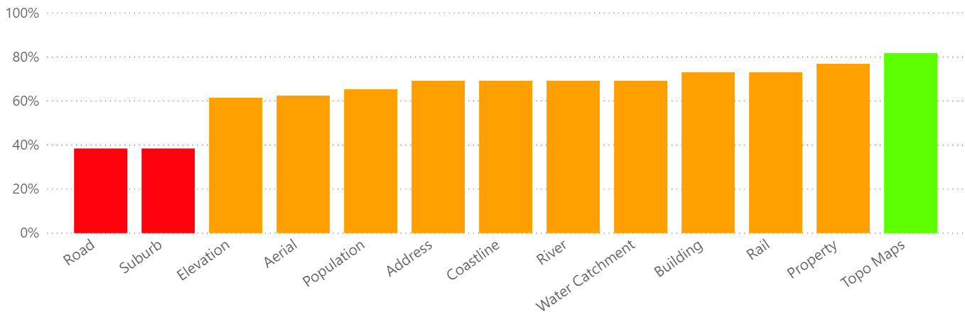
Do key datasets for resilience and climate change require improvement?
Significant improvement
Important improvement
Some improvement required
The Address key dataset is made up of Address from LINZ and Suburb from Fire and Emergency New Zealand.
Data Improvement Highlights: Quarter 2
✓ Stats NZ published
Statistical Area 1 data with population counts and other attributes
✓ NZTA published State Highway road closures on their
data portal a
nd data.govt.nz
✓
NIWA improved their
river webmap to display main rivers at a national scale
✓ Buildings fo
r Marlborough added to the national dataset on LINZ Data Service
✓ Aerial photography fo
r Bay of Plenty, Dunedin, Hamilton, Manawatu, Nelson and
PROACTIVELY RELEASED
Tasman published on LINZ Data Service
✓ LiDAR data fo
r Waikato a
nd Northland published on LINZ Data Service
✓ LINZ published
an elevation index to help identify LiDAR derived elevation data
✓ Learn how t
o convert LiDAR data to NZVD2016 vertical datum with this LINZ blog
✓ All lead agencies remain engaged with the key dataset improvement project
January 2020
Page 1 of 4


 Priority Improvements Update: Quarter 2
Below is a progress update for October to December 2019 (Quarter 2) and planned
milestones for January to March 2020 (Quarter 3). The icons represent improvement status:
on track to deliver
some improvements delivered
need organisation buy in
Quarterly progress updates are only shared with the NZGIS4EM Committee and the National
Emergency Management Agency (NEMA). An annual update on the data improvement plan
will be made publicly available by August 2020.
1. LINZ to provide a more comprehensive national coverage of
addresses
by June 2021.
Q2 Learned more about the address validation process. Working with
sample additional addresses to assess their quality and validity.
Q3 Start to identify outcomes for resilience customers and begin
customer engagement.
2. LINZ to work with all regions to coordinate the acquisition and release of
LiDAR data into open national datasets by June 2023.
RELEASED
Q2 LiDAR data has been published for Waikato and Northland.
Q3 Evaluate tenders, identify suppliers, with contracts in place for data
capture. Publish additional LiDAR data as it becomes available.
.
3. NZTA understands the importance of providing easy access to
road closure
data, but currently is unable to commit to an improvement plan.
Q2 NZTA restructure has taken priority, however State Highway road
closures have been published on NZTA data portal and data.govt.nz.
Q3 Create high level understanding of the work required by NZTA to
develop a national closed roads network. Also in discussion with
NEMA.
4. Stats NZ understands the importance of providing
small geography
population count information for use in responding to emergency events
and will explore options with LINZ on how best this could be achieved.
PROACTIVELY
Q2 Published 2018 Statistical Area 1 (SA1) data, similar to meshblock
areas, with population counts and additional attributes. LINZ
presented on key data project and use of population data in Pigeon
Valley Fire to Stats NZ senior managers.
Q3 Publish spatially enabled SA1 boundaries with attribution on Stats NZ
Data Finder and as Esri REST service. Develop data visualisation tool
to query and combine population counts for a selected area.
January 2020
Page 2 of 4


5. LINZ
to improve access to
parcel attribution by June 2020 and investigate
the feasibility of creating a property boundary layer by June 2021.
Q2 LINZ instructed Eagle Technology to set up a new ArcGIS Online
account nzbasemaps.maps.arcgis.com for publishing parcel data.
Property Data Management Framework white paper undergoing
expert review.
Q3 Publish NZ Primary Parcels as an Esri REST service. Look at security
options for restricted access to personal data.
Create functionality to support restricted access to some individual
Council District Valuation Roll data for testing. Publish Property Data
Management Framework externally.
6. LINZ
to complete national coverage of
building outlines by June 2020.
Q2 Published buildings for Marlborough. Started procurement for
Queenstown Lakes, Dunedin, Otago, Tasman and Nelson.
RELEASED
Q3 Publish buildings for Bay of Plenty and Gisborne. Investigate
capturing buildings where there is no aerial imagery e.g. Fiordland.
Procure data for Hamilton, Manawatu and Waikato.
7. Fire and Emergency New Zealand understands the importance of the
suburbs dataset and is working with LINZ to establish options regarding
the dataset by December 2019.
Q2 Fire and Emergency NZ received legal advice on the potential to
transition NZ Localities to a Creative Commons licence and measures
to ensure the integrity of the dataset for operational purposes.
Q3 Fire and Emergency will participate in the NZ Geographic Board’s
workshop to consider a ‘single point of truth’ for suburbs and
localities, and reiterate the need to ensure that any Public Risk in this
space can be mitigated in order to ensure the safety of the New
Zealand public in the context of emergency response services.
PROACTIVELY
8. LINZ to create a national
topographic basemap by June 2022.
Q2 Aerial imagery basemap development is progressing. Topo basemap
will be second basemap to be developed.
Q3 Aiming to develop aerial imagery basemap and test inhouse by
February 2020. Update website to provide information about Topo50
and Topo250 update schedule and link to update history.
January 2020
Page 3 of 4


9. LINZ to establish a process for coordinating the capture and delivery of
imagery and LiDAR during an event by June 2020.
Q2 Internal processes have been developed for supporting external
agencies by coordinating data capture during an emergency
response. Recent debrief identified lessons learnt following recent
storm event and Whakaari / White Island eruption.
Q3 LINZ to run staff exercise to test emergency response processes.
Draft specification for capturing aerial imagery during an emergency
to ensure timely data delivery. Plan user requirements workshop.
10. LINZ to create and maintain a national
coastline dataset based on the best
available data by June 2020.
Q2 Alternative options for an improved national coastline are being
evaluated, and worked on by our summer intern. NIWA, Northland and
Greater Wellington Regional Councils are helping define project scope.
Q3 Complete options investigation and agree the approach internally.
Progress towards the agreed approach to bring together the best
available LINZ coastline data. Continue engaging with stakeholders.
RELEASED
11. NIWA to improve the availability of
river network and water catchment
data by releasing under Creative Commons license and publishing scale
dependant webservices by June 2020.
Q2 NIWA have improve
d river webmap to control display of main rivers
at a small scale to create a national overview.
Q3 Improve metadata and test options for improved data delivery of
water catchments at a national and regional scale.
12. LINZ to publish key datasets as
Esri REST services by June 2020.
Q2 LINZ instructed Eagle Technology to set up a new ArcGIS Online
account for publishing key data basedatanz.maps.arcgis.com
Q3 Publish LINZ key datasets as Esri REST services
PROACTIVELY
13. KiwiRail to improve access to
rail network data by June 2020.
Q2 Some progress made on attribution and metadata. Recent focus has
been on GIS team structure changes at KiwiRail.
Q3 KiwiRail has recently lost both GIS staff, and will be focused on
recruitment and induction this quarter.
January 2020
Page 4 of 4