
 MILL ROAD CORRIDOR STUDY
ASSESSMENT OF
ECOLOGICAL EFFECTS
July 2008
MILL ROAD CORRIDOR STUDY
ASSESSMENT OF
ECOLOGICAL EFFECTS
July 2008
MILL ROAD CORRIDOR STUDY – ASSESSMENT OF ECOLOGICAL EFFECTS
TABLE OF CONTENTS
EXECUTIVE SUMMARY ................................................................................................................................................. 1
1
INTRODUCTION .................................................................................................................................................... 3
1.1
PROJECT OUTLINE ......................................................................................................................................................... 3
2
METHODOLOGY ................................................................................................................................................... 5
2.1
EXISTING LITERATURE REVIEW ........................................................................................................................................ 5
2.2
INDIGENOUS VEGETATION COMMUNITIES ........................................................................................................................ 5
2.3
AVIFAUNA ................................................................................................................................................................... 5
2.4
BATS ........................................................................................................................................................................... 6
2.5
AQUATIC BIOTA HABITATS ............................................................................................................................................. 6
2.6
HERPETOFAUNA AND TERRESTRIAL INVERTEBRATES ........................................................................................................... 6
2.7
DETERMINATION OF ECOLOGICAL SIGNIFICANCE ................................................................................................................ 6
3
DESCRIPTION OF EXISTING NATURAL FEATURES .................................................................................................. 7
3.1
DESCRIPTION OF ECOLOGICAL DISTRICTS .......................................................................................................................... 7
3.2
UNDERLYING GEOLOGY & SOILS ..................................................................................................................................... 8
3.3
INDIGENOUS VEGETATION.............................................................................................................................................. 8
3.4
AVIFAUNA ................................................................................................................................................................. 12
3.5
BATS ......................................................................................................................................................................... 12
3.6
FRESHWATER ENVIRONMENTS ...................................................................................................................................... 13
3.6.1
Water Quality ............................................................................................................................................... 13
3.6.2
Fish ................................................................................................................................................................. 14
3.6.3
Invertebrates ................................................................................................................................................. 15
3.7
OTHER INDIGENOUS FAUNA ......................................................................................................................................... 15
3.7.1
Reptiles .......................................................................................................................................................... 15
3.7.2
Native Frogs .................................................................................................................................................. 16
3.7.3
Terrestrial Invertebrates ............................................................................................................................... 16
3.8
INTRODUCED MAMMALS ............................................................................................................................................. 16
4
ECOLOGICAL SIGNIFICANCE ASSESSMENT AND THREATENED SPECIES .............................................................. 16
4.1
SIGNIFICANT NATURAL AREAS WITHIN THE CORRIDOR AREA ............................................................................................. 16
4.2
ECOLOGICAL SIGNIFICANCE ASSESSMENT USING ARC CRITERIA ......................................................................................... 16
4.3
THREATENED FLORA AND FAUNA .................................................................................................................................. 19
5
ASSESSMENT OF ECOLOGICAL EFFECTS .............................................................................................................. 19
5.1
SUMMARY OF POTENTIAL ECOLOGICAL EFFECTS .............................................................................................................. 19
5.2
GENERAL ADVERSE ECOLOGICAL EFFECTS FOR ALL OPTIONS .............................................................................................. 20
5.2.1
Threatened species ....................................................................................................................................... 20
5.2.2
Weeds ............................................................................................................................................................ 20
5.2.3
Aquatic Biota ................................................................................................................................................. 21
5.3
EFFECTS ON AVIFAUNA ................................................................................................................................................ 22
5.3.1
Fragmentation .............................................................................................................................................. 22
5.4
EFFECTS ON BATS ....................................................................................................................................................... 23
5.5
EFFECTS ON OTHER FAUNA ........................................................................................................................................... 23
5.6
OPTION C .................................................................................................................................................................. 26
5.7
OPTION D ................................................................................................................................................................. 27
5.8
OPTION J ................................................................................................................................................................... 28
5.9
OPTION I ................................................................................................................................................................... 29
5.10
OPTION K .................................................................................................................................................................. 29
6
CONCLUSIONS & RECOMMENDATIONS ............................................................................................................. 30
6.1
SUMMARY OF POTENTIAL ECOLOGICAL EFFECTS .............................................................................................................. 30
6.2
RECOMMENDATIONS FOR FURTHER PRE‐CONSTRUCTION MONITORING ............................................................................. 30
6.3
AVOIDANCE, REMEDIATION & MITIGATION RECOMMENDATIONS ..................................................................................... 31
6.4
ENVIRONMENTAL MANAGEMENT PLAN & POST‐MONITORING REQUIREMENTS ................................................................. 31
© Kessels & Associates Ltd
DRAFT I 280708
MILL ROAD CORRIDOR STUDY – ASSESSMENT OF ECOLOGICAL EFFECTS
7
REFERENCES & BIBLIOGRAPHY ........................................................................................................................... 33
Appendix I
Road Alignment Option Details (OPUS, July 2008)
Appendix II
Flora Species List
Appendix III
Bat Survey Methodology
Appendix IV
Threatened Environment Classification Map – Manukau City
Version:
DRAFT I 28 July 2008
Prepared by:
Britta Deichmann (MSc equiv. - Germany) & Brenda Aldridge (MSc hons1),
with contributions from Andrea Dekrout (PhD)
Reviewed by:
Gerry Kessels (MPhil hons1) & Theresa Walsh (Planning Consultant)
Approved by:
Garth Vipond (Manukau City Council)
This document and its contents is the property of Kessels & Associates Limited. Any unauthorised employment or reproduction, in
full or in part, in any format, is forbidden. © Kessels & Associates Ltd 2008.
All photographs are the property of Kessels & Associates Limited unless otherwise stated.
575 Grove Road
R.D.5
Hamilton 3285
www.kessels-ecology.co.nz
Document Ref: ..\Kessels & Associates Server\Manukau City Council\Mill Rd corridor study: Mill Road AEE DRAFT I 280708
© Kessels & Associates Ltd
DRAFT I 280708
MILL ROAD CORRIDOR STUDY – ASSESSMENT OF ECOLOGICAL EFFECTS
1
Executive Summary
Background
Manukau City Council has commissioned Kessels & Associates Ltd to undertake an assessment
of ecological effects (AEE) for Mill Road / Redoubt Road realignment options investigations. Of
the originally twelve alignment options, seven have been discarded during the specialist
evaluation workshop, which was held on 18th April 2008, leaving five options to be assessed in
greater detail within this study.
This ecological assessment constitutes the results of a detailed investigation of the ecological
values of the proposed corridor area and the ecological constraints of the overall project, including
an evaluation of:
•
The location, extent, type and significance of terrestrial and aquatic indigenous
vegetation communities, existing protected natural areas and fauna habitats supported
within the project area.
•
Results of botanical, avifauna and aquatic biota surveys carried out between March
and July 2008.
•
The nature and magnitude of any potential adverse ecological effects arising from each
proposed road alignment option on key ecological features.
•
A broad outline of suitable avoidance, remediation and mitigation measures required to
address any potential adverse ecological effects.
•
An outline of the requirements of further ecological investigations and monitoring
requirements.
Description of Existing Vegetation
All options largely traverse a pastoral and urban landscape with no indigenous plant or animal
habitats remaining. However, within stream gullies, patches of native bush and small wetland and
seepage zones still persist. Some of these are modified and subject to weed intrusion, but others,
largely, thanks to the efforts of private landowners, contain intact indigenous vegetation
communities, many of which are under-represented within the Auckland Region. Principally,
these stands contain mature taraire and puriri forest with kahikatea and wetland species
dominating the wet gully floors. Several seepage zones remain in the otherwise almost
completely cleared gullies within Totara Park in the north-west of the subject area.
Avifauna
Birds consist of common exotic and native species, with reasonably abundant populations of tui
and kereru evident within the bush remnants. North Island kaka are visiting the area occasionally.
Bats
New Zealand long-tailed bats have previously been found both within the Hunua Ecological
District, where the proposed corridor area is situated. Though no surveys have been conducted in
the corridor area, long-tailed bats may be present at this locality.
Aquatic Biota
Fish and aquatic macroinvertebrate habitats consist of species reflecting a reasonably modified
semi-urban environment, which pollution tolerant species dominating the silty and mobile
substrates.
Ecological Sensitivity Assessment
According to the threatened environments classification described by Walker
et al. (2007) the
main proportion of the proposed corridor area is situated within “Category 3 - At risk”. However,
the proposed alignment options C and D would directly affect indigenous vegetation within an
area classed as “Category 1 - Acutely threatened” (refer to the map in Appendix IV). The
© Kessels & Associates Ltd
DRAFT I 280708
MILL ROAD CORRIDOR STUDY – ASSESSMENT OF ECOLOGICAL EFFECTS
2
potentially affected indigenous vegetation remnants were also assessed against the Auckland
Regional Council Regional Policy Statement criteria and two bush remnants are considered to be
of regional significance.
Effects on Indigenous Ecosystems
Options J, I and K are situated within an ideal location from an ecological perspective. These
options are largely situated within pasture/urban landscape, and largely follow existing roads,
consequently do not dissect any significant natural features.
Options C and D would comprise the crossing and clearance of indigenous bush (yet to be
quantified, but likely to be less than 1 ha) as well as significant tree trimming, causing habitat loss
and disturbance to indigenous wildlife. The dissection of these forest remnants will also result in
fragmentation and disruption of ecological corridor values. Substantial mitigation will be required
should these options be pursued.
No endangered, rare, threatened or vulnerable plant species or plant communities would be
directly affected by any of the proposed alignment options. However, kereru and North Island
kaka are present in the area and longfin eel and koura are reported in the Freshwater Fish
Database for both Puhinui Creek and Papakura Stream. Further surveys for NZ long-tailed bats
and lizards are proposed to confirm with greater certainty that these threatened species are not
utilising the site if either Option C or D become the preferred options.
No fish or aquatic macroinvertebrate habitats would be adversely affected provided appropriate
sediment control measures are adopted. As all perennial stream crossings are proposed to be
bridges, no specific fish passage provisions are required. At this stage water abstraction
requirements are unknown. Provided that suitable storage and/or non-fully allocated water
sources can be devised and found, water abstraction during construction should result in no more
than minor adverse effects on in-stream biota.
The key aspects, which require further investigation, are:
• Assessment of the potential effects of the water abstraction requirements once exact
hydrological needs are known.
• Further wildlife surveys should Option C or D be pursued.
• Development of a detailed Ecological Restoration & Monitoring Plan should Option C or D
be pursued.
© Kessels & Associates Ltd
DRAFT I 280708
MILL ROAD CORRIDOR STUDY – ASSESSMENT OF ECOLOGICAL EFFECTS
3
1 Introduction
1.1
Project Outline
Manukau City Council has commissioned Kessels & Associates Ltd to undertake an assessment
of ecological effects (AEE) for the proposed Mill Road / Redoubt Road realignment. Mill Road
and Redoubt Road provide an arterial road connection east of State Highway 1 between
Papakura District and Manukau City (Figure 1). They connect the suburbs Flat Bush and
Takanini, which are constantly growing. The occurrence of a significant number of accidents has
even more increased the need to carry out a corridor study aiming to identify a more suitable route
that can cope with this increased pressure.
Twelve alignment options have been assessed, seven of which have been discarded during a
specialist evaluation workshop, which was held on 18th April 2008. Five remaining options, three
for the main west-east connection (C, D, J) and two for the north-south connection to Murphy’s
Bush (K, I), have been assessed in greater detail within this study (Figure 2).
The details of each alignment option, i.e. location, earth-work requirements etc. were detailed by
OPUS in July 2008 and are attached as Appendix I.
This study constitutes the results of a detailed assessment of the ecological (aquatic, terrestrial
and avifauna) values of the site, including an evaluation of:
• The type and significance of terrestrial and aquatic values supported within the project
area;
• Results of botanical, aquatic and fauna surveys carried out between March and July
2008;
• The sensitivity and significance of these ecological features within the local, regional
and national context;
• The nature and magnitude of any ecological effects arising from the proposed
alignment options; and
• An outline of possible avoidance, remediation, mitigation and monitoring measures
required to address any potential adverse ecological effects.
While alignment option J mainly follows the existing Mill Road, the other options will cross pasture
land as well as some remnants of indigenous forest and scrublands (Figure 2). There are also a
number of small seepage zones and streams scattered within the site, which could be affected by
the proposed road alignments. The nearest protected natural areas are Totara Reserve and
Murphy’s Bush Scenic Reserve.
© Kessels & Associates Ltd
DRAFT I 280708
MILL ROAD CORRIDOR STUDY – ASSESSMENT OF ECOLOGICAL EFFECTS
4
Hunua Ecological District
Totara Park
Manukau Ecological District
Figure 1
Location map including Ecological District Boundary
Figure 2
Overview of the five remaining alignment options assessed in this study
© Kessels & Associates Ltd
DRAFT I 280708
MILL ROAD CORRIDOR STUDY – ASSESSMENT OF ECOLOGICAL EFFECTS
5
2 Methodology
This report is based on a general field survey of the study area conducted in March 2008, three
other detailed site visits in early April, late May and late July 2008, a review of existing literature
and databases, as well as the local knowledge of the authors. The key reference documents for
this project are the detailed road alignment option descriptions provided by OPUS (July 2008),
which are attached as Appendix I.
During the general field survey key ecological “hot spots” were identified, where potential adverse
effects may be greatest. Intensive fieldwork studies were conducted in those “hot spots”.
The following surveys were conducted:
• Detailed
botanical
surveys;
• Avifauna
surveys;
• Weed and animal pest assessments;
• Vegetation
typing;
and
• Visual assessments of freshwater aquatic biota habitats.
All proposed alignment options were inspected and assessments made based on the site visits
combined with an assessment of existing data and literature.
Further fauna surveys on long-tailed bats/pekapeka (
Chalinolobus tuberculatus) should be
scheduled for the upcoming summer (December 2008 to March 2009) if options C, D or I, which
lead through bush areas, are considered to be taken further. An addendum report could be
issued by May 2009 to report on this further monitoring.
2.1
Existing Literature Review
All existing databases and reports were reviewed to determine where the key significant
natural areas and waterways are located and to ascertain their characteristics. Specifically
the following documents and databases were reviewed:
• Manukau District Plan Maps;
• Hunua Ecological District Protected Natural Areas Programme (PNAP) report;
• Auckland Regional Plan;
• National Freshwater Fish Database; and
• Ornithological Society of New Zealand (OSNZ) national bird-distribution database.
2.2
Indigenous Vegetation Communities
Vegetation within the corridor area was visually assessed during the three site visits in April, May
and July 2008. Broad indigenous vegetation communities were mapped on recent aerial
photography and incorporated into the project’s GIS database (Figure 3).
Where indigenous vegetation was potentially impacted by clearances required for any of the
proposed alignment options, for project machinery or component transport, the species present
were recorded, with particular attention paid to uncommon or unusual species.
Several wetlands and seepage zones were also visually assessed for dominant vegetation types
and threatened or unusual plant species.
2.3
Avifauna
On site bird surveys in form of point records (opportunistic surveys), which involve counting all
birds seen or heard within a 100 m radius of an observer, have provided an overview of the
species present and an estimate of species abundance within the proposed corridor area. In
addition, the review of the Ornithological Society of New Zealand (OSNZ) records provides an
outline of the distribution of the rare and common avifauna within the study area.
© Kessels & Associates Ltd
DRAFT I 280708
MILL ROAD CORRIDOR STUDY – ASSESSMENT OF ECOLOGICAL EFFECTS
6
2.4
Bats
No specific site surveys were conducted for bats at this stage. However, the long tailed bat
(
Chalinolobus tuberculatus) has been recorded in the Hunua Ecological District and surveys on
long tailed bats are therefore recommended for the period December 2008 - January 2009 (see
Appendix III for details) to detect if bats are present within the subject area. An addendum report
could be issued in March 2009 to report on this further monitoring.
In New Zealand it is not necessary to capture bats for species census as the calls of the two
occurring species are very distinct. Surveys can be conducted by teams of observers who slowly
(approximately 3 km per hour) walk along a predetermined path, listening for the sound of bat
echolocation calls with a heterodyne bat detector set to 40 kHz (O’Donnell & Sedgeley, 1999).
2.5
Aquatic Biota Habitats
Visual assessments of freshwater aquatic biota habitats were undertaken during the site visits and
the National Freshwater Fish Database (FFDB) was reviewed. A brief inspection of the
macroinvertebrate populations was undertaken during the site visit in July 2008.
2.6
Herpetofauna and Terrestrial Invertebrates
No specific surveys were conducted for herpetofauna or terrestrial invertebrates. However, data
from the Hunua Ecological District Protected Natural Areas Programme (PNAP) survey was
reviewed to give a general list of native lizard species expected in the region of the proposed
corridor area.
2.7
Determination of Ecological Significance
Section 6.4.7 of the Auckland Regional Policy Statement (RPS) gives some guidance to the
criteria used to evaluate Significant Natural Areas. It is summarised as follows:
1.
The significance of natural heritage resources in the Region, and the identification of the
qualities and values which give rise to their significance, shall be determined using criteria
including the following:
(i)
the extent to which an area is representative or characteristic of the natural diversity in
an ecological district or contains outstanding or rare indigenous community types;
(ii)
the presence of a threatened species or uncommon, special or distinctive features;
(iii)
the extent to which a natural area can maintain its ecological viability over time;
(iv)
the extent to which an area is of sufficient size and shape to maintain its intrinsic
values;
(v)
the relationship a natural feature has with its surrounding landscape, including its role
as an ecological corridor or riparian margin, and the extent of buffering or protection
from external adverse effects;
(vi)
the natural diversity of species of flora and fauna, biological communities and
ecosystems, geological or edaphic features such as landforms and land processes,
parent material, and records of past processes;
(vii)
the diversity of ecological pattern, such as the change in species composition or
communities along environmental gradients;
(viii) the extent to which an area is still reflective of its original natural character and quality;
(ix)
the extent to which an area provides an important habitat for species at different
stages of their life cycle, e.g., breeding, spawning, roosting, feeding, and haul-out
areas for the New Zealand fur seal;
(x)
the importance of an area to Tangata Whenua.
2.
In assessing natural heritage resources, their contribution to the viability of the Region’s
ecosystems will be considered significant if they exhibit the following characteristics:
(i)
the area provides a characteristic example of the ecology of the local area; and
(ii)
the area is of good quality (e.g., for natural areas it has an intact understorey and is
characterised by a low level of invasion from pest species); and
© Kessels & Associates Ltd
DRAFT I 280708
MILL ROAD CORRIDOR STUDY – ASSESSMENT OF ECOLOGICAL EFFECTS
7
(iii)
the area contributes to the ecological viability of surrounding areas and biological
communities; or
(iv)
the area contains a Regionally threatened species or a unique or special feature; or
(v)
the area contains an unprotected ecosystem type, or an ecosystem type under-
represented within the protected area network of an ecological district; or
(vi)
the area is a component of, adjoins or provides a buffer to, a significant natural
resource, or a watercourse or coastal margin; or
(vii)
the area has habitat values, or provides or contributes to a habitat corridor or
connection facilitating the movement of fish or wildlife species in the local area; or
(viii) the area is in a landscape which is depleted of indigenous vegetation; or
(ix)
the protection of the area adds significantly to the spatial characteristics of the
protected area network (e.g., by improving connectivity or reducing distance to the
next protected area); or
(x)
the area is significant to Tangata Whenua; or
(Refer also to Chapter 3 - Matters of Significance to Iwi)
(xi)
there is a community association with, or public appreciation of, the aesthetic values of
the landform or feature.
3.
The heritage value of freshwater ecosystems shall be progressively identified and protected
from the adverse effects of use and development."
The key natural features were also assessed against the “The Threatened Environment
Classification” GIS map as described by Walker
et al. (2007) (Appendix IV). The Threatened
Environment Classification uses indigenous vegetation as a surrogate for indigenous biodiversity,
which includes indigenous ecosystems, habitats and communities. Walker
et al. (2007) state that
the Threatened Environment Classification “is most appropriately applied to help identify places
that are priorities for formal protection against clearance and/or incompatible land uses, and for
ecological restoration to restore lost species, linkages and buffers”. The classification identifies six
threat categories as follows:
Category Criteria
Category
Name
1
< 10 % indigenous vegetation left
Acutely Threatened
2
10-20 % indigenous vegetation left
Chronically Threatened
3
20-30 % indigenous vegetation left
At Risk
4
>30 % left & 10 % protected
Critically Under-protected
5
>30 % left & 10-20 % protected
Under-protected
6
>30 % left & > 20 % protected
Less Reduced & Better Protected
3 Description of Existing Natural Features
3.1
Description of Ecological Districts
An Ecological District (ED) is a scientifically determined region, which reflects the underlying
biophysical characteristics of a locality. Each ED has a number of unique or distinctive natural
habitat features (usually botanical), which distinguish it from neighbouring Ecological Districts.
The proposed corridor area is situated within the Hunua ED in the Auckland Ecological Region
with the north-western end reaching into the Manukau ED.
Hunua Ecological District
The Hunua Ecological District still supports a relatively high proportion of native bush. In general,
the early vegetation within this district would have been kauri-podocarp-broadleaved forests, with
kauri particularly prominent on the ridges. In some places, where the soils have formed from
volcanic rocks and ash, the fertility is higher and the species present reflect this. Puriri and taraire
often dominate on these more fertile soils.
© Kessels & Associates Ltd
DRAFT I 280708
MILL ROAD CORRIDOR STUDY – ASSESSMENT OF ECOLOGICAL EFFECTS
8
Because of their size and sometimes high levels of connection, the bush areas within the Hunua
Ecological District are often important habitats. In general, these are considered to be good
habitat on the basis of the populations of the more common bush birds they support. Some of the
areas are important for kereru, which was once thought common, but is now considered to be
gradually declining. However, while birds are often the focus, this is usually because they are
more visible than other fauna. For example, geckos and even native bats, are likely to rely upon
many of these habitats, but because they are harder to see, they are often not mentioned.
Manukau Ecological District
The Manukau Ecological District has been largely cleared of native vegetation and almost all of its
wetlands have been drained. Only 1.6% of the entire Manukau Ecological District has native
vegetation of any type remaining on it. Reduction to around 20% of former extent is usually
considered to be significant. Reduction to below 5% is considered to be severe. The reductions
in the Manukau Ecological District are well below these levels. The only significant area of natural
landscape remaining is the Manukau Harbour itself. Any remaining examples of original forests or
wetlands, or any regenerating native vegetation that is developing into vegetation that once
clothed the district therefore need to be considered as significant.
The early vegetation of the Manukau Ecological District was a mix of conifer-broadleaved forests
and wetlands in peaty areas. On the flat lands, the terrain is slightly undulating, with some areas
being slightly raised and better drained and other areas being sunken and often saturated. The
drier areas on flat lands would once have supported lowland conifer-broadleaved forest of a range
of species including totara, kahikatea, taraire, puriri, pukatea, kohekohe and titoki. On wet soils in
peaty depressions, kahikatea would have dominated with swamp maire and pukatea growing in
and under the kahikatea canopy. On the most poorly drained soils there would have been
sedgelands.
3.2
Underlying Geology & Soils
The Mill Road corridor area is situated on low lying to undulating foothills and flatlands.
The soils within the Hunua Ecological District are mainly hill and steepland clayey soils with
impeded drainage (some podzolised) from strongly weathered sedimentary rocks. Small areas of
clayey but friable, well drained loam soils are present on easier slopes from old, strongly
weathered volcanic ash. Loamy, poorly drained and gleyed alluvial soils occur in the valleys. The
soils on the hilly and steep slopes show complex patterns, which are reflected in the vegetation.
The Manukau ED is characterised by basalt lava and other deposits from Pliocene-Quaternary
age volcanoes in the central region, fringed to the north and south by Pliocene to Holocene
sediments. Pleistocene sediments form a large area in the north close to the study area.
Within Manukau ED, poorly drained, gleyed alluvial soils and peat deposits are the dominant soil
types on the river flats and swamps, with small pockets of volcanic loam soils from basaltic lava
and scoria scattered throughout the ecological district. Silty, generally well drained loam soils from
old strongly- weathered volcanic ashes are dominant on the rolling and hilly land, while strongly
leached and podzolised clayey soils, from strongly weathered sedimentary rocks, occur on the
hilly and steep slopes (McEwen, 1987; Pohlen, 1965).
3.3
Indigenous Vegetation
Of the once widespread podocarp-broadleaved forests and the kahikatea swamp forests that
were extensive in pre-human times throughout both ecological districts, only the occasional small
forest remnant remains within the gullies of the study area. These remnants have a species
composition of warm temperate forests and are often dominated by taraire and puriri with the
occasional kauri. Kahikatea are dominant on the wet gully floors. The transition from taraire to
tawa forest was obvious in the Tiffany Bush area. Several seepage zones remain in the otherwise
almost completely cleared gullies within Totara Park in the north-west of the subject area.
Those natural areas that could be directly affected by one of the alignment options are described
in detail below (refer to Figure 3 for the numbering). Area 4 contains mainly exotic ornamental
tree species and is not described in further detail. Common names are used in the text; for a
species list containing the botanical names refer to Appendix II.
© Kessels & Associates Ltd
DRAFT I 280708
MILL ROAD CORRIDOR STUDY – ASSESSMENT OF ECOLOGICAL EFFECTS
9
Figure 3
Natural areas affected by the proposed alignment options
Bush block 1 - affected by Option D
The vegetation in this gully is largely weed infested especially around the margins and in the
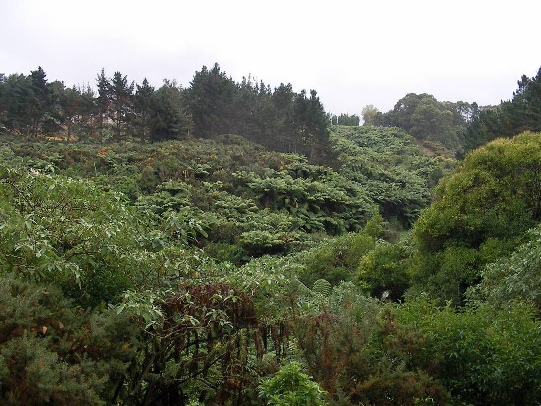
northern end adjacent to the Watercare area. Although mainly classified as exotic scrub, it shows
influences of secondary semi-coastal podocarp-broadleaved forest (Photo 1).
Where the proposed option D crosses, the margins are dominated by pines, woolly nightshade
and gorse with species such as Chinese privet, tree privet, Himalayan honeysuckle and pampas
occurring throughout on the sideslopes. Exotic species of the groundcover include wandering
Jew, creeping buttercup, Kikuyu grass, lotus, black nightshade, hedge woundwort as well as
common pasture herbs and grasses. One moth plant specimen was noted on the gully floor as
well.
Native species present at the proposed crossing include one large (20 m tall) puriri, the treeferns
mamaku and ponga, as well as shrub species like kawakawa, hangehange, kanono and saplings
of nikau and mapou. Juvenile kiekie and flowering NZ passionfruit were also observed. Native
groundcover species included swards of
Carex geminata and raupo, other
Carex species, ferns
like ring fern and water fern, shrubby haloragis and bamboo grass.
A small perennial stream is contained in this gully, which is further described in chapter 3.6.
Further south towards Mill Road, the canopy of this gully contains large specimens of kahikatea,
taraire and rewarewa with the occasional young rimu, as well as cabbage tree, nikau and kanuka.
Ponga and mamaku are present as well and kahakaha was noted in the crowns of the larger
trees. Seedlings of mapou and pigeonwood are common. Additional weed species that occur
around the margins of this area include blackberry, Japanese honeysuckle and montbretia.
© Kessels & Associates Ltd
DRAFT I 280708
MILL ROAD CORRIDOR STUDY – ASSESSMENT OF ECOLOGICAL EFFECTS
10
Photo 1
Overview of bush block 1
Bush blocks 2 & 3 - affected by Options C & D
Bush block 3 has been fenced off from stock for more than twelve years. Both Bush blocks 2 and
3 are both understood to be legally protected as Council Covenants under the Reserves Act 1977,
although verification is required.
These two bush blocks are rare examples of old growth semi-coastal podocarp-broadleaved
forest with a canopy height of 20-25 m. The DBH (diameter breast height) of some specimens
were measured as follows: kahikatea, kohekohe and taraire – 600 mm, puriri – 1240 mm, rimu –
370 mm and kanuka – 350 mm.
The canopy of this forest type contains a diverse mixture of conifer and broadleaved species, with
taraire and puriri being dominant on the slopes and kahikatea being dominant on the gully floor
(Photo 2). Rimu, tanekaha, the odd matai and pukatea emerge through the canopy and mahoe,
tawa, karaka, pigeonwood, mapou, cabbage tree and nikau add to the diversity. Totara, kanuka,
lancewood and titoki are present on the drier slopes and ponga, wheki and mamaku are common
treeferns. NZ passionfruit and two climbing rata species are present lianes. Epiphytes include the
ferns hound’s tongue fern, fragrant fern, hanging spleenwort, sickle spleenwort, filmy fern, fork
fern and leather-leaf fern as well as kahakaha.
The understorey supports species such as mapou, hangehange, young lancewood, karamu,
kanono, putaputaweta and the occasional flax.
Coprosma spathulata and mingimingi grow higher
up the slopes. Lacebark, kauri,
Pittosporum, korokia and five-finger species have been planted
along the margins of the western gully (2).
An abundance of seedlings of various different species is present in the groundcover, namely
karaka, mahoe, pigeonwood, taraire, mangeao and puriri. Ferns make up most of the
groundcover with thread fern, sweet fern,
Lastreopsis microsora and gully fern being the most
dominant species. The groundcover also contains a variety of pasture herbs and grasses, as well
as bamboo grass, nertera and hookgrass.
The orchid
Acianthus sinclairii was noted on the lower slopes close to the stream and bamboo
orchid grows epiphytic in the canopy.
A number of different fungi species was noted as well.
© Kessels & Associates Ltd
DRAFT I 280708
MILL ROAD CORRIDOR STUDY – ASSESSMENT OF ECOLOGICAL EFFECTS
11
A large number of weed species was noted along the southern margins of these stands that are
adjacent to Mill Road. Observed tree and shrub species are a macrocarpa, poplar, bamboo,
wattle, woolly nightshade, gorse, Himalayan honeysuckle and Chinese privet. Exotic groundcover
species are black nightshade, Arum lily, inkweed, elephant’s ear, both ginger species,
Agapanthus, garden nasturtium, wandering Jew, bindweed, montbretia,
Cyperus sp., daisy, mint
and ragwort. Periwinkle and gorse were the main weed species observed along the north-
western margin of bush block 3.
Photo 2
Canopy of bush block 3; showing large taraire, puriri, kahikatea and rimu
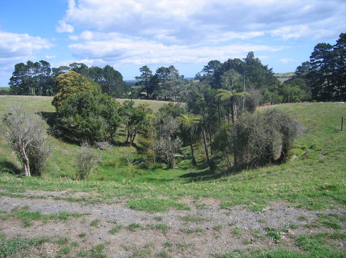
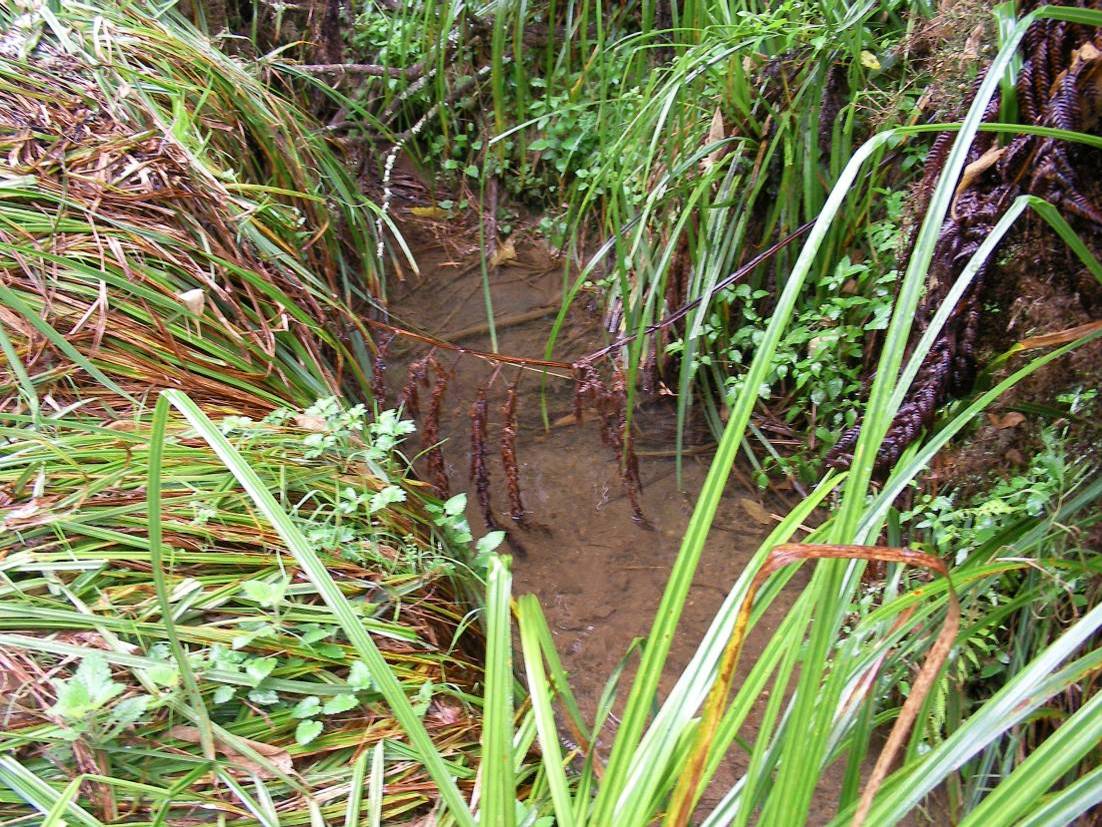
Area 5 - affected by Options C & D
The small gullies in Totara Reserve contain small seepage zones in the gully heads, which for the
most part, contain mostly pasture grasses and weeds with few native species (Photo 3). These
gullies contain the headwaters of the Puhinui Stream, which is further described in chapter 3.6.
Juncus effusus, water pepper and pasture grasses are the most common groundcover species on
the gully floors. The slightly drier slopes are mainly cleared with only a few trees and shrubs
remaining. The only native species present close to the gully heads are ponga, manuka and
pigeonwood seedlings. Further down the gullies, a few tall (15 m) totara and kahikatea remain in
conjunction with mahoe, wheki, mamaku, gully tree fern, hangehange, manuka, mingimingi and
mapou. The climbing pohuehue was also present. Weed species present include tree privet,
Chinese privet, barberry, woolly nightshade and gorse.
Most of the gullies contain streams with minimal flow or sometimes stagnant (in May 2008), which
are mainly ephemeral and incised.
© Kessels & Associates Ltd
DRAFT I 280708
MILL ROAD CORRIDOR STUDY – ASSESSMENT OF ECOLOGICAL EFFECTS
12
Photo 3
One of the seepage zones affected by Options C & D
3.4
Avifauna
Resident bird populations within the study area comprise mostly of common native and exotic
species of open grasslands, including a variety of small, mostly exotic passerines like blackbird,
song-thrush, sparrow, yellowhammer and finches, as well as Australasian harrier, kingfisher,
pukeko, rosella, magpie, Indian myna and spur-winged plover. Tui, kereru, silvereye, fantail and
grey warbler were heard in bush blocks 2 and 3 (refer to Figure 3) and North Island kaka and
shining cuckoo have been reported to be visiting the area. Bellbird are recorded in the Hunua
Ranges in increasing numbers and may be able to spread back into smaller forest remnants, such
as the ones in the subject area, in the future.
3.5
Bats
There are two species of native bat in New Zealand – the lesser short-tailed bat (
Mystacina
tuberculata) and the long-tailed bat (
Chalinolobus tuberculatus). Lesser short-tailed bats are
currently thought to be restricted in their range to forest reserves in the central North Island and
lower South Island (King, 2005). Although short tailed bats are forest specialists, they are not
likely to be found within the study site. The long-tailed bat, however, has a wider distribution in the
North Island of New Zealand. Conversely, long-tailed bats are often found in open areas foraging
extensively over farmland (Griffiths, 1996; Borkin, 1999) and frequenting forest edges or low
density regenerating kanuka (
Kunzea ericoides) and manuka (
Leptospermum scoparium) forests
(O’Donnell, 2001b). New Zealand long-tailed bats have been found within the Hunua ED (in the
Hunua Ranges).
Extensive surveys have not previously been conducted in the corridor area. However, it is not
unlikely that long-tailed bats are present within this site. Long-tailed bats are dormant during
periods of cold weather movement and therefore surveys have not been undertaken at this stage.
The long-tailed bat has been classified as nationally vulnerable (Hitchmough
et al., 2007).
Detailed monitoring of the site should therefore be conducted in the summer to determine
absence or presence of this species, and to enable the assessment of possible disturbance of the
New Zealand long-tail bat through the project (see Appendix III for details).
© Kessels & Associates Ltd
DRAFT I 280708
MILL ROAD CORRIDOR STUDY – ASSESSMENT OF ECOLOGICAL EFFECTS
13
3.6
Freshwater Environments
The proposed Mill Road re-alignment will potentially affect two streams; the headwaters of the
Puhinui Stream and Creek, and the mid-reach of the Papakura Stream.
The Puhinui Stream flows through Totara Park which is managed by Manukau City Council. The
Puhinui Stream flows for approximately 12 km before discharging into the Manukau Harbour,
encompassing a catchment of approximately 2220 m2. Puhinui Stream is considered to be highly
modified in parts and as a result a restoration concept plan has been created for the stream. The
key ecological restoration goals for the stream include: reduction of flood and stream side erosion,
enhance wildlife, restore historic and cultural resource, restore and improve water quality and
habitat, and restore physical and biological functioning (Puhinui Stream Restoration Concept Plan,
2002).
One of the headwaters of the Puhinui Stream is present in bush block 1 in form of a small first
order perennial stream (according to ARC Regional Plan guidelines). Where the proposed
alignment option (D) crosses, its dry wetted width is 1 m and its wetted width is 700 mm (Photo 4).
The run depth is 3-5 cm and some shallow pools are present of up to 10 cm depth. The substrate
is soft silt with occasional gravel and small cobble.
The Papakura Stream crosses the boundary between Manukau City and Papakura District
Councils and has a catchment area of 56 km2. The Papakura Stream catchment is primarily rural
and discharges to the Pahurehure Inlet of the Manukau Harbour. A flood management plan was
prepared by Beca Carter Hollings and Ferner Ltd. in June 1993 for the stream. The report was
prepared as a result of the flooding in the catchment, particularly surface flooding upstream of Mill
Road, which attenuates peak flows downstream (Beca Carter Hollings and Ferner Ltd, 1993).
Photo 4
Stream present in bush block 1
3.6.1 Water Quality
The Auckland Regional Council routinely monitors several of the streams, estuaries and lakes
within the Auckland Region. Included in the routine surveys are the Papakura and Puhinui
Streams. The survey site for the Papakura Stream is located at Porchester Road (Map Reference
R11: 814 620), the catchment landuse is primarily pastoral 85% with a small amount of urban
© Kessels & Associates Ltd
DRAFT I 280708
MILL ROAD CORRIDOR STUDY – ASSESSMENT OF ECOLOGICAL EFFECTS
14
landuse 0.7%. The survey site for the Puhinui Stream is located at ford (Map Reference R11: 768
660), the catchment landuse is 52.3% pastoral and 39.8% urban.
The results of a 10 year monitoring program (from 1992 to 2002) for these streams have been
adapted from the Auckland Regional Council Technical Publication 207 (2003), and are presented
in Table 1.
Both streams have similar seasonal temperature values for the 10 year period (1992 to 2002).
However, the values were slightly higher in the Puhinui Stream particularly in summer; this may be
the result of heated surface water runoff from impermeable surfaces.
The dissolved oxygen levels were higher in the Puhinui Stream. Dissolved oxygen is a measure
of the oxygen levels within the water and can be affected by a number of processes including,
water flow (riffle habitat), aquatic plants and oxygen consumption by micro-organisms. The
consumption of oxygen by micro-organisms is referred to as the biological oxygen demand
(BOD). The median BOD levels are low at 1 mg/L, which is below the ANZECC (2000)
physiochemical stressor guideline for protection of aquatic species at 5 mg/L.
Water transparency, turbidity and suspended sediment loads have been measured for the
streams. The Papakura Stream has a higher transparency and less suspended solids, but
interestingly has a higher turbidity than the Puhinui Stream.
Presumptive and faecal coliform levels are greater in the Puhinui Stream than the Papakura
Stream. The Papakura Stream has a greater catchment area and is dominated by pastoral land
use, which can impact faecal levels in a stream.
In general the Papakura Stream has a larger catchment dominated by pastoral land use, which
has impacts on the water quality of the stream. This stream has a lower dissolved oxygen level
and higher presumptive and faecal coliform levels than the Puhinui Stream. The Puhinui Stream
has a mixed pasture and urban landuse, which has impacted the water quality resulting in higher
summer temperatures, lower transparency and higher suspended sediment levels, all of which are
likely to be the result of increased surface runoff.
Table 1 Median water quality results for 2002 from monthly recordings at Papakura and
Puhinui Streams
Water Quality Parameters
Papakura Stream
Puhinui Stream
Temperature (°C)
14.2
14.5
Dissolved Oxygen (%)
71.7
96.8
Biological Oxygen Demand (mg/L)
1
1
Black Disk Transparency (m)
0.62
0.45
Turbidity (NTU)
6
1.5
Suspended solids (mg/L)
3.7
6.9
Presumptive coliforms (MPN/100mL)
4000
3650
Faecal coliforms (MPN/100mL)
3000
1000
3.6.2 Fish
No specific fish surveys have been undertaken for this study. However, common bullies have
been observed during the May site visit in the Puhinui tributary situated in the gully crossed by
alignment option D.
The Papakura Stream and Puhinui Creek and tributary have been fished previously with the
results on the freshwater fish database (FFDB) displayed in Table 2.
Six fish species have been captured in the Papakura Stream, while five fish species and
freshwater crayfish were recorded in the Puhinui Creek and tributary. The streams have four
species in common, with longfin eel and inanga recorded in Papakura Stream and not in Puhinui
Creek and koura in Puhinui Creek but not Papakura Stream.
© Kessels & Associates Ltd
DRAFT I 280708
MILL ROAD CORRIDOR STUDY – ASSESSMENT OF ECOLOGICAL EFFECTS
15
The presence of longfin eel and koura at these sites is of importance as these species are
considered to be threatened and in gradual decline (Hitchmough
et al., 2007). Both species are
also important culturally as food sources. Longfin eels are often upland species and prefer to
reside in headwater streams with abundant cover in the form of overhead shade and undercut
banks. Large eels are top predators in freshwater environments feeding on smaller fish and
koura. Koura seek refuge and habitat in undercut banks.
All of the fish species recorded, except mosquito fish, are native and diadromous species,
requiring part of their life stage to be spent in the ocean as well as freshwater. These fish enter
the freshwater environment through the Manukau Harbour, where the streams discharge. The
presence of these fish indicates that access to these sites is sufficient (i.e. there are no barriers to
migration).
Mosquito fish are small fish that have been described as aggressive and are able to tolerate
adverse ecological conditions such as high temperatures and salinities. In ideal conditions these
pest fish can reproduce rapidly (within weeks) giving birth to numerous live young. They can
therefore dominate and possibly out-compete native fish in ideal conditions. However, these fish
are often found in high numbers where conditions are not suitable for native fish species (i.e.
stagnant pools and drains).
Inanga make up a significant component of the whitebait run, migrating into streams in late spring,
early summer. Another whitebait species that is common in Auckland urban streams is the
banded kokopu, while this species was not recorded on the FFDB records, it could occur within
these streams.
Table 2
FFDB results for the Papakura Stream and Puhinui Creek and tributary extracted 15/07/2008
Minimum
Maximum
Stream
Fish species
Year
Abundance
length (mm)
length (mm)
Papakura Stream
Longfin eel
Anguilla dieffenbachii
2000, 2001 common
150
400
Common bully
Gobiomorphus cotidianus
2000, 2001 rare
50
60
Shortfin eel
Anguilla australis
2000, 2001 common
200
Redfin bully
Gobiomorphus huttoni
2000, 2001 rare
60
70
Inanga
Galaxias maculatus
2001 common
Mosquito fish
Gambusia affinis
2001 occasional
Puhinui Creek
Koura
Paranephrops
1997 rare
and tributary
Common bully
Gobiomorphus cotidianus
1997 common
30
40
Shortfin eel
Anguilla australis
1997, 1998 abundant
100
700
Mosquito fish
Gambusia affinis
1998 abundant
20
40
Redfin bully
Gobiomorphus huttoni
1997 common
3.6.3 Invertebrates
No macroinvertebrate samples were taken from the streams for this preliminary survey. However,
a brief inspection of the macroinvertebrate population has been undertaken during the July site
visit, and the results indicate that the predominant macroinvertebrate species assemblages are
dominated by small crustaceans (
Paracalliope &
Paraleptemphobus), freshwater snails
(
Potamopyrgus) and true fly larvae (mostly
Austrosimulium &
Orthocladiinae). All of these species
are pollution tolerant and typical of intensively managed pastoral catchments, as well as being of
small, first order upper stream systems.
3.7
Other Indigenous Fauna
3.7.1 Reptiles
Although not recorded in this survey, the forest areas in within the subject corridor are likely to
provide habitat for several geckos and skinks. Six lizard species (forest, Pacific grey and
Auckland green geckos and copper, ornate and shore skinks) have been recorded in the Hunua
Ecological District. Three of these species are considered to be in gradual decline and of national
conservation concern - the Auckland green gecko, the Pacific grey gecko and the ornate skink.
Although there are numerous secure island populations of the ornate skink, there is concern about
the level of mainland decline in this species. Forest gecko and green gecko are likely to be found
© Kessels & Associates Ltd
DRAFT I 280708
MILL ROAD CORRIDOR STUDY – ASSESSMENT OF ECOLOGICAL EFFECTS
16
in the forests and scrublands within and adjacent to the study area. The ornate skink is found in
lowland areas throughout the North Island.
3.7.2 Native Frogs
Native frogs (
Leiopelma spp.) have not been observed or reported in the region of the proposed
Mill Road / Redoubt Road corridor (PNAP Report, 1999).
However the seepage areas and gullies are likely to provide habitat for two exotic frog species:
Litoria aurea and
Litoria raniformis.
3.7.3 Terrestrial Invertebrates
Hundreds of different indigenous insect species may be found within the study area. However,
few areas in this region have been seriously sampled for their invertebrates. Insufficient data is
available of the molluscan faunas in the subject area; however, more than 100 landsnails have
been identified within the Hunua ED (PNAP Report, 1999).
Glow-worms (
Arachnocampa luminosa) are present along the stream within bush area 3.
3.8
Introduced Mammals
Feral animals are found throughout the study area. Rabbits, possums, hares and hedgehogs are
widespread. Feral cats, ferrets and stoats are likely to be present.
4 Ecological Significance Assessment and Threatened Species
4.1
Significant Natural Areas within the Corridor Area
Virtually all remaining natural areas in the Hunua and especially the Manukau ED are considered
to be important natural features because of their scarcity.
While 23% of the Hunua ED is covered by natural areas under some form of protective tenure for
conservation (PNAP Report, 1999), only 1.6 % of the Manukau ED total land area remains under
native vegetation cover. Forest types with taraire dominant canopy now only cover 0.8% of the
land area in Manukau Ecological District.
According to the threatened environments classification described by Walker
et al. (2007) the
main proportion of the proposed corridor area is situated within Category 3 - At risk. However, the
southern end of the corridor area, which includes Bush Areas 2 & 3, is classed as Category 1 -
Acutely Threatened (refer to the map in Appendix IV). In effect this indicates that any indigenous
vegetation within this criteria zone is nationally under-represented (less than 10%) and also under-
protected nationally.
No wetlands of regional ecological importance are located within the corridor area. However, the
seepage zones within Totara Park can be considered as ecologically significant given the degree
of modification wetlands have suffered regionally and nationally.
4.2
Ecological Significance Assessment using ARC Criteria
The following table includes the ecological significance assessment using the ARC criteria for
bush areas 1, 2 and 3, as well as for the seepage zones (area 5) in Totara Park.
© Kessels & Associates Ltd
DRAFT I 280708
MILL ROAD CORRIDOR STUDY – ASSESSMENT OF ECOLOGICAL EFFECTS
17
Table 3
Ecological Significance Assessment using ARC criteria
Summary of ARC Criteria
Bush block 1
Bush block 2
Bush block 3
Area 5 - seepage zones
1. the natural area is representative or characteristic of the
NO
YES - the area
YES - the area
NO
natural diversity in the ecological district or containing
contains elements of contains elements of
outstanding or rare indigenous community types
semi-coastal forest
semi-coastal forest
2. the area is of good quality (e.g., for natural areas it has an NO - the vegetation is YES - both canopy
YES - both canopy
NO - exotic species are
intact understorey and is characterised by a low level of
largely weed infested, and understorey are
and understorey are
dominant
invasion from pest species
native species only
well developed and
well developed and
remain on the lower
weed species are
weed species are
slopes and the gully
uncommon
uncommon
floor
3. the area contains an unprotected ecosystem type, or an
NO
YES - the vegetation YES - the vegetation NO
ecosystem type under-represented within the protected area
type is
type is
network of an ecological district
underrepresented in
underrepresented in
Manukau ED, but not Manukau ED, but not
in Hunua ED
in Hunua ED
4. the area is in a landscape which is depleted of indigenous YES - the area is
YES - the area is
YES - the area is
YES - the area is situated
vegetation
situated within a
situated within a
situated within a
within a "Category 1 -
"Category 1 - Acutely "Category 1 - Acutely "Category 1 - Acutely Acutely threatened" area
threatened" area
threatened" area
threatened" area
according to the
according to the
according to the
according to the
Threatened Environments
Threatened
Threatened
Threatened
Classification
Environments
Environments
Environments
Classification
Classification
Classification
5. presence of a threatened species or uncommon, special
YES - kereru and
YES - kereru and
YES - kereru and
NO
or distinctive features
North Island kaka are North Island kaka are North Island kaka are
present in the area
present in the area
present in the area
and utilize the bush
and utilize the bush
and utilize the bush
area
area
area
6. the natural area can maintain its ecological viability over
NO - not possible
YES
YES
NO - threatened by stock
time
unless major weed
intrusion and weed
control measures are
species
carried out
7. the natural area is of sufficient size and shape to maintain YES - if weed control YES
YES
NO - not unless fenced
its intrinsic values
measures were
and planted up with
carried out
suitable native species
8. relationship the natural feature has with its surrounding
YES - the bush area - YES - the bush area
YES - the bush area
YES - although heavily
landscape, including its role as an ecological corridor or
although weed
forms an ecological
forms an ecological
depleted gul y systems as
riparian margin, and the extent of buffering or protection
infested - forms an
corridor and is a buffer corridor and is a buffer such form important
from external adverse effects
ecological corridor and for a perennial stream for a perennial stream ecological corridors
is a buffer for a
perennial stream
© Kessels & Associates Ltd
DRAFT I 280708
MILL ROAD CORRIDOR STUDY – ASSESSMENT OF ECOLOGICAL EFFECTS
18
9. contains a good natural diversity of species of flora and
NO - although the
YES - the bush
YES - the bush
NO
fauna, of ecological patterns, such as the change in species area combines forest comprises a good
comprises a good
composition or communities along environmental gradients, and stream
diversity of indigenous diversity of indigenous
or of geological or edaphic features such as landforms and
ecosystems the
flora and fauna
flora and fauna
land processes, parent material, and records of past
diversity of indigenous species and combines species and combines
processes
flora and fauna is only forest and stream
forest and stream
moderate
ecosystems which
ecosystems which
follow environmental follow environmental
gradients
gradients
10. the area is still reflective of its original natural character
NO
YES
YES
NO
and quality
11. the area provides an important habitat for species at
YES - the stream
YES - both the canopy YES - both the canopy NO
different stages of their life cycle, e.g., breeding, spawning, contained in the gul y trees as well as the
trees as well as the
roosting or feeding
may provide important stream contained in
stream contained in
habitat for native fish
the gully provide
the gully provide
species
important habitat for
important habitat for
indigenous fauna
indigenous fauna
12. the protection of the area adds significantly to the spatial YES
YES
YES
YES
characteristics of the protected area network (e.g., by
improving connectivity or reducing distance to the next
protected area)
13. importance of the area to Tangata Whenua
unknown
unknown
unknown
unknown
14. there is a community association with, or public
NO
YES - the bush area is YES - the bush area is YES - the seepage zones
appreciation of, the aesthetic values of the landform or
of interest to a local
of interest to a local
are situated within Totara
feature
landcare group
landcare group
Park which is the largest
public reserve within the
Manukau District
© Kessels & Associates Ltd
DRAFT I 280708
MILL ROAD CORRIDOR STUDY – ASSESSMENT OF ECOLOGICAL EFFECTS
19
4.3
Threatened Flora and Fauna
This survey did not collect detailed information on threatened species, and further survey work
would be necessary to do this. However, the nationally threatened king fern (
Marattia salicina)
(listed by Hitchmough
et al., 2007 as being in the threat category of ‘serious decline’) was
observed at the site and the regionally uncommon swamp maire (
Syzygium maire)
was found in
association with a few very large (1.5 m tall) and uncommon
Carex secta specimens. All of these
species were present in the Tiffany Bush area, which is situated within the corridor area, but will
not be affected by any of the proposed alignment options.
Kereru (Gradual Decline – bush and scrublands) were observed within bush areas 2 and 3 and
North Island kaka (Critical – native bush) have been reported to be visiting the area occasionally.
There are another six known nationally threatened fauna species, which may be found in a variety
of habitats within the study area (Hitchmough
et al., 2007). These are:
•
Longfin eel – Gradual Decline – upper catchment streams, wetlands and rivers.
•
Koura – Gradual Decline – most streams within the study area.
•
North Island long-tailed bat – Nationally vulnerable – bush and scrub.
•
Auckland green gecko – Gradual Decline – bush and scrublands.
•
Pacific grey gecko – Gradual Decline – bush and scrublands.
•
Ornate skink – Gradual Decline – bush and scrublands.
5 Assessment of Ecological Effects
5.1
Summary of Potential Ecological Effects
The proposed Mill Road / Redoubt Road alignment options largely follow existing roads or are
crossing extensively farmed pasture land. However, options C and D will cross ecologically
significant indigenous forest remnants containing streams and could also affect a few seepage
zones within Totara Park.
Potential impacts of the proposed road alignments on indigenous vegetation, streams and wildlife
can be divided into two groups – direct impacts and indirect impacts. These are summarised as
Table 4. The potential ecological factors presented to fauna by the construction of new roads can
be characterised into three broad classes of hazard factors. These comprise of:
1) a behavioural element, caused by fauna avoiding the vicinity of the turbines as a
behavioural response to a visual stimulus and/or sound stimulus;
2) a physical habitat element, where fauna respond to destruction, modification or
creation of habitat associated with infrastructure construction; and
3) a direct demographic element, resulting from mortality arising from physical collisions
with traffic.
More specifically, direct impacts could include:
• habitat loss and damage and destruction of plants and other wildlife, in the course of
road construction; and
• sediment run-off from road construction affecting water quality and aquatic biota
habitat quality.
Indirect impacts could include:
• loss, damage, modification or fragmentation of existing plant communities and wildlife
habitat;
• disturbance from traffic and associated activities (noise, visual);
• reduced breeding success of individual birds or other wildlife nesting in close proximity
to the road;
© Kessels & Associates Ltd
DRAFT I 280708
MILL ROAD CORRIDOR STUDY – ASSESSMENT OF ECOLOGICAL EFFECTS
20
• new weeds being introduced into indigenous plant communities by machinery etc; and
• increased predation and scavenger pressure in adjoining fauna habitats, as the new
alignment may remove critical habitat for certain species, reducing overall habitat
quality.
These effects can largely be avoided, remedied or mitigated for by the implementation of suitable
construction and restoration measures. In particular, it is recommended that the main tool for
giving effect to these requirements should be detailed in a Construction Environment
Management Plan (CMEP) and if an option is chosen, which traverses a significant indigenous
vegetation remnant, a detailed Ecological Restoration & Monitoring Plan.
5.2
General Adverse Ecological Effects for all Options
5.2.1 Threatened species
No nationally threatened plant species were found in the vegetation surveys within the corridor
area, which would be removed as part of the road construction.
However, kereru and North Island kaka are present in the bush areas and longfin eel and koura
are listed in the Freshwater Fish database for Papakura Stream and Puhinui Creek.
In addition, if either Options C or D are selected, further bat and lizard surveys are recommended
to ensure none of these species potentially utilise the road corridor.
5.2.2 Weeds
The corridor area is already highly weed infested. Nonetheless, vehicles and other material
brought in to the site can quickly introduce new weeds and/or spread existing ones. Measures to
minimise the effects and introduction of new weed species are required.
Fresh earth exposed during clearance and construction will provide ideal conditions for the further
spread of weeds already existing within the area. Furthermore, machinery and aggregate brought
in from other areas increases the risk of new weed species establishing within the existing natural
areas. Therefore, it is critical that all machinery and aggregate is thoroughly cleaned, or otherwise
guaranteed free of attached seed or plant matter before it is brought on site.
Provided due care and initial weed control is carried out as and when required, it is expected that
the indigenous species will quickly gain a foot-hold and dominate vegetative cover along access
road batters and cuts.
Mitigation Requirements
Measures to minimise effects of the introduction of weeds include:
• As far as possible, confining vehicle movements to formed accessways;
• Ensuring construction vehicles are cleaned between jobs (to avoid introducing soil from
other sites on tyres, etc);
• As far as possible, ensuring aggregate sources are free of weeds;
• Undertaking routine monitoring of site works to ensure new infestations are detected and
removed before they have an opportunity to spread;
• Scrape off existing topsoil and plant matter for each turbine site within nature features,
stockpile and use to re-sow exposed areas as required; and
• Re-sow and/or replant all turbine sites within indigenous forest areas with locally-sourced
native grasses and low-growing shrubs within or adjacent to existing indigenous
vegetation remnants.
The detailed measures required to achieve the aforementioned measures should be incorporated
into a Construction Environmental Management Plan (CEMP).
© Kessels & Associates Ltd
DRAFT I 280708
MILL ROAD CORRIDOR STUDY – ASSESSMENT OF ECOLOGICAL EFFECTS
21
5.2.3 Aquatic Biota
Construction Effects
Adverse ecological effects associated with sediment runoff are well documented for New Zealand
freshwater ecosystems (e.g. Ryan, 1991; Boubee
et al., 1997). Potential adverse effects
associated with sediment runoff from exposed excavations and works directly within the stream
bed may cause significant and pro-longed sediment discharges if not adequately controlled.
Particular care needs to be taken to ensure sediment runoff does not affect the stream
ecosystems downstream during construction and during preloading of any abutments and
embankments. Streams and rivers within the catchment of the site provide good habitat for a
range of fish and invertebrate species which are sensitive to modification and high silt loadings.
Provided that robust silt control measures are employed, construction effects are likely to be no
more than minor.
A number of seepage zones are found within the study area. It will be important to consider the
placement of excavation material in order to reduce sedimentation of these areas. Excavation
material should not be placed in seepage zones or in steep areas. Provided robust silt control
measures are employed during construction seepage zones should not be adversely affected by
the construction.
Construction of the fill embankments should be undertaken in the dry season, so as to minimise
work within the water. It is important to ensure no spillage when pouring any concrete when
working with concretes over the waterway.
Concrete can be particularly toxic to aquatic life. During construction care will be needed to avoid
silt and concrete from directly discharging into the waterway.
If any of the options entail the removal of stream and riparian margin vegetation, this direct impact
would need some form of replacement or enhancement of similar stream habitat elsewhere within
the catchment.
Because no culverts, and only bridges, are proposed over all perennial waterways, no specific
measures for maintaining fish or invertebrate passage are required.
Operational Effect
Motor vehicles emit a range of substances which deposit onto the road surface and surrounding
areas. The substances most likely to adversely affect the surrounding ecosystems are zinc,
copper and aromatic hydrocarbons. Pollutants and sediments carried by water runoff and aerial
dispersal from the completed road may have some impact on receiving waters.
Moreover, the risk of accidental spills discharging into the adjacent waterways could cause
significant adverse effects and stormwater runoff could be diverted to discharge to ground
soakage if feasible to avoid this risk.
Dilution rates may not be sufficient to reduce contaminant loading to below guideline
concentrations (ANZACC, 2000). A precautionary approach in stormwater drain design should be
adopted in this situation as vehicle per day movements are likely to be over 20,000. Wherever
practical, stormwater drains should be designed to run over grass swales and should also be fitted
with sediment sumps. This would be expected to reduce contaminant loadings to acceptable
levels.
Mitigation Requirements
A Sediment Management Plan would address adverse ecological effects associated with silt run-
off and ensure implementation of appropriate control measures during construction. There are a
number of best practicable options for silt control, many of which are detailed in Auckland
Regional Council’s “
Erosion and Sediment Control Guidelines for Land Disturbing Activities –
TP90”.
Monitoring during construction will ensure that any potential erosion problem areas are identified
at an early stage. Appropriate contingency measures can then be undertaken quickly.
© Kessels & Associates Ltd
DRAFT I 280708
MILL ROAD CORRIDOR STUDY – ASSESSMENT OF ECOLOGICAL EFFECTS
22
Where possible, temporary silt ponds should be retained as permanent features, replanted with
appropriate wetland plants, in order to attenuate flood flows and treat contaminants from road run-
off discharges, in addition to the use of grass swale drains and sediment sumps.
5.3
Effects on Avifauna
Resident bird populations within the study area comprise mostly of common native and exotic
species of open grasslands, including a variety of small, mostly exotic passerines like blackbird,
song-thrush, sparrow, yellowhammer and finches, as well as Australasian harrier, kingfisher,
pukeko, rosella, magpie, Indian myna and spur-winged plover. Tui, kereru, silvereye, fantail and
grey warbler were heard in bush blocks 2 and 3 (refer to Figure 3) and North Island kaka and
shining cuckoo have been reported to be visiting the area.
Local disturbance to these populations is likely to occur during construction works, but as the
overall proportion of habitat loss is very small and short-term for these species, the existing bird
populations are likely to readily re-establish following completion of works if they do indeed
become displaced in the first instance. From a regional perspective the loss of indigenous bird
habitat is considered to be minor, as only a relatively small area of vegetation that is immediately
available will be lost. Moreover, as farmland already cuts through the forest remnants, adverse
effects on bird species with large home ranges is likely to be minor.
However, tui, bellbird and kereru move on a daily and seasonal basis between remnants for food,
roosting and breeding requirements and seed dispersal functions (Robertson, 1988; Pierce &
Graham, 1995). Tui and kereru tend to fly between forest remnants during the day and on “a line
of sight” basis, travelling over 50 km to reach suitable food sources (Robertson, 1988). Thus, in
the short-term, the loss of even less than 1 ha may reduce overall food supplies for these species.
Replanting of indigenous species on cut and fill batters and enhancement of the ecological health
and condition of nearby fragments would reduce these effects.
There is no research in New Zealand to assess how these particular species cope with
obstructions such as roads. The behaviour of each particular species may be different, but
ecologically important birds such as bellbird, tui and to a lesser extent, kereru appear to adapt to
noise and light associated with roads and urban environments (personal observations). The
ability of these key indicator species to adapt to the new alignment and become accustomed to
associated noise and movement should not be underestimated. The birds would easily be able to
fly over the road. On the other hand, further fragmentation of habitat may allow greater influxes of
predators, such as stoats and feral cats. Although, as the stands are small now, predators are
likely to have unimpeded access at present. Nonetheless, these indigenous birds are under
pressure at the moment and any small decline in habitat quality or quantity may cause additional
stresses, which would adversely affect diversity and abundance.
Summary
Overall, in consideration of the habitat available and densities of birds present the impact on birds
is likely to be low from a regional perspective, but more severe with Options C and D. Mitigation is
required. This could be implemented through the proposed Ecological Restoration & Monitoring
Plan.
5.3.1 Fragmentation
Fragmentation of the landscape produces a series of fragmented patches surrounded by a matrix
of differing vegetation types or land use (Saunders
et al., 1987). The formation of a fragmented
landscape can have considerable consequences on the species utilising the area as it may
increase the isolation of a patch, reducing species dispersal from one patch to another and create
barriers to normal dispersal and colonisation processes. Fragmentation effects could thus
potentially lead to the extinction of species if fragmentation is extensive enough. The magnitude
of fragmentation effects will largely be dependent on the shape and size of the patches, which are
formed, the distance between patches and the composition of the surrounding matrix (Murcia,
1995). The composition of the surrounding matrix may completely prevent, reduce or increase
movement between patches.
© Kessels & Associates Ltd
DRAFT I 280708
MILL ROAD CORRIDOR STUDY – ASSESSMENT OF ECOLOGICAL EFFECTS
23
In New Zealand forests edge effects result in the propagation of shade intolerant species. The
creation of an edge can negatively affect specific life cycle stages of some plants while favouring
others. For instance changes in solar radiation affecting seedling germination and survival of
species, such as kohekohe, but favours ponga, totara and mapou (Young & Mitchell, 1994).
These changes will ultimately lead to changes in community composition on the edge and in the
interior. Edge effects also result in a reduction of canopy height from the forest interior towards
the edge, causing merging of forest canopy and subcanopy layers at the edge (Oosterhoorn and
Kappelle, 2000).
For Options C and D fragmentation effects could be significant and suitable mitigation and
restoration measures will be required.
Mitigation Requirements
A number of options are available for mitigation of forest edges. Three major issues need to be
addressed (1) replacement/restoration planting on exposed soil and (2) sealing the newly created
edge and (3) reducing overall fragmentation of bush in the area by increasing patch size.
Specifically the following recommendations for addressing potential edge effect effects are:
1.
Planting newly exposed, open ground with suitable, locally sourced (where possible) native
species would help reduce colonisation and establishment of weedy exotic species.
2.
Planting the new forest edge with a dense band of fast growing native species to help
reduce weed incursion into the forest.
3.
Targeted additional planting of native bush with fencing against stock to improve the over all
patch size and there by reduce the effects of fragmentation.
5.4
Effects on Bats
New Zealand bats are non-migratory; they show a high fidelity for their natal home ranges
(O’Donnell, 2000). This suggests that long-tailed bats do not undertake long, non-echolocation
flights and thus may be able to detect and avoid new structures such as bridges.
For many aerial hawking bats, including long-tailed bats, insect activity is the best predictor for bat
activity (O’Donnell, 2001a). If the road lights would be shielded from the ground (to minimise
visual impacts for local residents), the risk of insects being attracted to them and thereby the risk
of bat strike is considered to be minimal.
Conclusions
To assess any potential conflict between bats and the proposed Mill Road / Redoubt Road
alignment options, it first needs to be established with a high degree of certainty whether there are
any bats within the area. Further surveys within the breeding season are therefore recommended
should either Options C or D be chosen (refer to Appendix III). If bats are identified in the area,
monitoring of bat movement is recommended to assess how much they use the area and to
establish risk and options for mitigation.
Mitigation Requirements
It is possible that the effects of the proposed road alignments will be more than minor on the local
long-tailed bat populations if bats are found within or adjacent to any of the proposed alignment
options. Further monitoring is required before construction to ascertain if there will be any
potential adverse effects on bats at this locality. In addition, at each of the proposed bush
clearance sites, specific pre-clearance surveys are required to ascertain if bat roosting sites would
be directly removed.
5.5
Effects on other Fauna
Because there is no major vegetation clearance proposed, the geckos and skinks are unlikely to
be affected by any of the road alignments.
© Kessels & Associates Ltd
DRAFT I 280708
MILL ROAD CORRIDOR STUDY – ASSESSMENT OF ECOLOGICAL EFFECTS
24
It is also unlikely that native terrestrial molluscs are reliant on the habitats which are to be
disturbed as part of this proposal.
No other indigenous fauna species, such as insects (including flying insects), are expected to be
adversely affected by any of the road alignment options. The main potential effects on terrestrial
invertebrates are:
• Displacement due to disturbance;
• Habitat change and loss; and
• Disruption to flight paths/dance of flying insects.
Disturbance during construction is unlikely to lead to the displacement of indigenous invertebrates
or their habitats where the options follow existing roads. However, wherever an alignment option
does not follow an existing road the new structure will form a wide permanent barrier to insect
movement. The mating dance of some taxa may be influenced by disruptions to airflows, but as
most insects are localised and reproductive dance activity occurs in calmer conditions any effects
are expected to be negligible or no more than minor.
Mitigation Recommendations
Little information is available about the condition and make up of lizard populations and no
detailed studies have been conducted within the proposed corridor area. However, many locally
found indigenous lizard species are threatened species or consent of localised populations in
gradual decline. Therefore, the potential exists for any new environmental pressure to have
consequences for local populations.
If either Options C or D becomes the preferred option, monitoring is recommended to determine if
lizards are indeed utilising this area and if mitigation is required.
© Kessels & Associates Ltd
DRAFT I 280708
MILL ROAD CORRIDOR STUDY – ASSESSMENT OF ECOLOGICAL EFFECTS
25
Table 4
Ecological Effect Risk Assessment Matrix
SIGNIFICANT POTENTIAL DIRECT ADVERSE
POTENTIAL INDIRECT ADVERSE
AVOIDANCE, REMEDIATION, MITIGATION
MONITORING
ECOLOGICAL EFFECTS
ECOLOGICAL EFFECTS
REQUIREMENTS
REQUIREMENTS
Forests
Yes – clearance necessary for Options C and D
Loss of habitat, edge effects, native birds,
Weed control, suitable CEMP & mitigation
Regular monitoring for weeds
weeds.
measures
Wetlands
No – provide that fill disposal sites are not placed
Sediment discharges during construction
Weed control, suitable CEMP & mitigation
within identified wetlands and seepage zones
measures
Threatened Plants
None affected
Terrestrial Fauna
Insect
Minor – insect strike with attraction to lights
Minor
Shield lights to reduce risk of insect aggradation
Pre & post site surveys
Herpetofauna
Minor
Minor
Avifauna
Minor - bird strike
Minor
Aquatic Biota
Yes - stream crossings for roads construction
Yes – silt runoff and fish/invertebrate migration Yes – silt management good practice measures
Yes – water quality during construction
impediments through culverts
and fish friendly culverts
Yes- abstraction of water during construction
Fencing off of stream margins & replanting with
native plants
Key Threatened Fauna Species
NZ pigeon (kereru)
Minor - potential strike – moderate risk & low localised
potential effect only
North Island kaka
Minor - potential strike – moderate risk & low localised
potential effect only
Long-fin eel & koura
Minor – if suitable silt control measures undertaken
Long tailed bat
None to minor – but further survey required if Options
Further bat and ornate skink survey
C or D chosen
proposed pre-construction to confirm low
risk/ no presence assumptions
Lizards
None to minor – but further survey required if Options
C or D chosen
© Kessels & Associates Ltd
DRAFT I 280708

MILL ROAD CORRIDOR STUDY – ASSESSMENT OF ECOLOGICAL EFFECTS
26
5.6
Option C
The main ecological impact of this option is the crossing of bush blocks 2 and 3 (Photo 5).
Although the two gullies will be crossed with bridges and batters will be kept to a minimum, a small
area of ecologically significant semi-coastal podocarp broadleaved forest will need to be cleared
or the crowns trimmed. Given the density of the stand and the amount of large trees present, it is
likely that up to ten large trees would be removed.
Provided that silt control measures are carried out, the effects on the streams in these gullies are
considered to be minor and should only occur during the construction phase.
Noise and visual effects may disturb present birds.
This option may also have potentially significant adverse effects on the seepage zones in the gully
heads in Totara Park (Photo 6). Two of the present gully heads will be filled in and some – mainly
exotic – vegetation removed. This option is therefore associated with the disturbance of upper
catchment habitat for indigenous fish species and the discharge of sediments into the catchment
during construction.
For the most part the seepage areas found in Totara Park contain mainly pasture grasses and
weeds with few native species. However, Collier & Smith (2005) note the high and largely
unknown biodiversity and wider ecosystem function values of seep areas. Given the high
ecological values of seepage zones, all overburden sites should therefore avoid direct impact into
the seepage wetlands wherever possible.
If Option C is chosen, strict sediment and post-construction rehabilitation measures will need to be
undertaken.
The construction of a pond for the treatment of stormwater runoff from the road is not considered
to cause major adverse effects. In fact, the construction of this pond may create a valuable
habitat, especially if combined with appropriate restoration measures of the gully system.
Photo 5
Aerial view of the proposed crossing of Option C through bush blocks 2 & 3
© Kessels & Associates Ltd
DRAFT I 280708
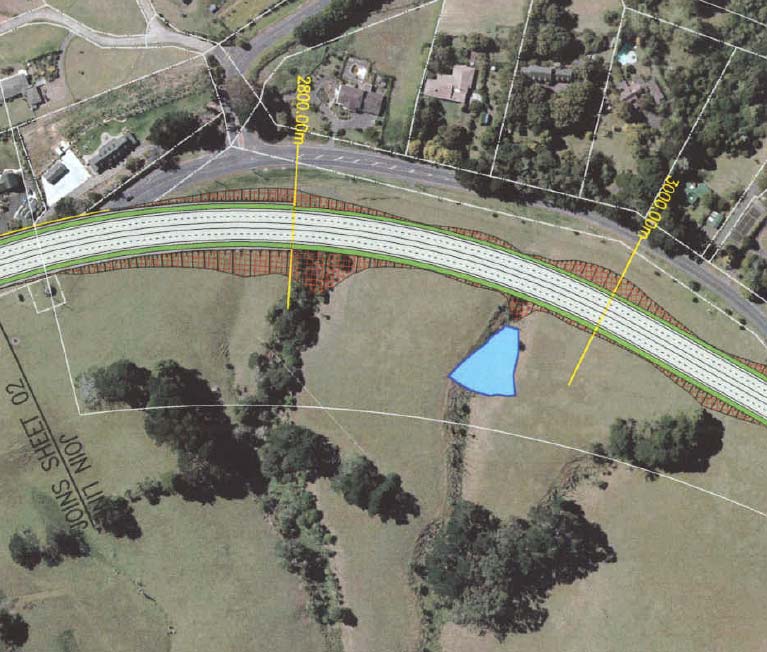
MILL ROAD CORRIDOR STUDY – ASSESSMENT OF ECOLOGICAL EFFECTS
27
Photo 6
Proposed realignment of Options C & D at Totara Park, showing infill of gully heads
and proposed stormwater storage pond
5.7
Option D
Option D causes the same ecological effects as Option C within Totara Park (see above for
details).
This option also includes the crossing of two bush areas (1 and 3) and the associated loss of
mature trees and habitat (Photo 7).
Bush block 1 (on the left) will be crossed via a 180 m span bridge. The construction of this bridge
will include the removal of some large pine trees on the top of the gully slopes and possibly some
exotic shrubs. Any remaining native vegetation in this area is contained on the lower slopes and
on the gully floor and will therefore not be effected through clearance.
The crossing of bush area 3 will include the construction of a 50 m span bridge. Bush clearance
will be reduced to a minimum, but one large taraire would be removed and some trimming may be
necessary.
© Kessels & Associates Ltd
DRAFT I 280708
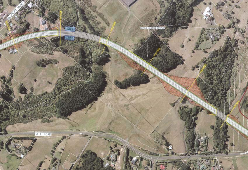
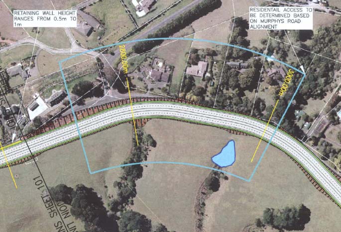
MILL ROAD CORRIDOR STUDY – ASSESSMENT OF ECOLOGICAL EFFECTS
28
Photo 7
Crossing of Option D through bush block 1 (left) and 3 (right)
5.8
Option J
Option J largely follows the existing Mill Road alignment with only a small intrusion into Totara
Park (Photo 8). The rest of the road works for this alignment includes cuts, which will cause the
removal of weed infested roadside vegetation. The amount of habitat loss through this option is
insignificant compared to the other options.
The overall ecological effects of Option J are considered to be negligible. This option therefore is
the preferred alignment from an ecological point of view.
Photo 8
Alignment of Option J in Totara Park
© Kessels & Associates Ltd
DRAFT I 280708
MILL ROAD CORRIDOR STUDY – ASSESSMENT OF ECOLOGICAL EFFECTS
29
5.9
Option I
Option I largely follows the existing Murphy’s Road alignment and only includes the removal of
some large exotic ornamental trees at the intersection with Mill Road.
The effects of this option are considered to be less than minor.
5.10 Option K
Option K will cut through pasture land over the entire length, which is of minimal value from a
biodiversity perspective, and no vegetation clearance or stream crossings will be involved. As this
option is situated on a ridgeline, the streams on either side may be affected if no appropriate silt
control measures are carried out.
The effects of this option are considered to be negligible.
© Kessels & Associates Ltd
DRAFT I 280708
MILL ROAD CORRIDOR STUDY – ASSESSMENT OF ECOLOGICAL EFFECTS
30
6 Conclusions & Recommendations
6.1
Summary of Potential Ecological Effects
Options J, I and K are situated within an ideal location from an ecological perspective. These
options are largely situated within pasture/urban landscape, and largely follow existing roads,
consequently do not dissect any significant natural features.
Options C and D would comprise the crossing and clearance of indigenous bush (yet to be
quantified, but likely to be less than 1 ha) as well as significant tree trimming, causing habitat loss
and disturbance to indigenous wildlife. The impacted vegetation type is not classified as nationally
threatened; however, the forest remnants are situated within an area classed as acutely
threatened according to the Threatened Environment Classification by Walker
et al. (2007) and is
considered to be regionally significant. The dissection of these forest remnants will also result in
fragmentation and disruption of ecological corridor values. Substantial mitigation will be required
should these options be pursued.
No endangered, rare, threatened or vulnerable plant species or plant communities would be
directly affected by any of the proposed alignment options. However, kereru and North Island
kaka are present in the area and longfin eel and koura are reported in the Freshwater Fish
Database for Puhinui Creek and Papakura Stream. Further surveys for NZ long-tailed bats and
lizards are proposed to confirm with greater certainty that these threatened species are not
utilising the site if either Option C or D become the preferred options.
No fish or aquatic macroinvertebrate habitats would be adversely affected provided appropriate
sediment control measures are adopted. As all perennial stream crossings are proposed to be
bridges no specific fish passage provisions are required. At this stage water abstraction
requirements are unknown. Provided that suitable storage and/or non-fully allocated water
sources can be devised and found, water abstraction during construction should result in no more
than minor adverse effects on in-stream biota.
The key aspects, which require further investigation, are:
• Assessment of the potential effects of the water abstraction requirements once exact
hydrological needs are known.
• Further wildlife surveys should Option C or D be pursued.
• Development of a detailed Ecological Restoration & Monitoring Plan should Option C or D
be pursued.
6.2
Recommendations for further Pre-Construction Monitoring
Bats
Little information is available about the condition and make up of long-tailed bat populations and
no detailed studies have been conducted on the bat population in the proposed area. Currently it
is not possible to predict population effects resulting from any wind power-related mortality.
However, bats tend to be long lived but slow to reproduce; female long-tailed bats produce only
one pup per year (King, 2005). Therefore, the potential exists for any new environmental
pressure, no matter how slight, to have consequences for local populations of long-tailed bat.
Monitoring is recommended to determine if bats are utilising this area and if mitigation is required
should Options C or D be chosen. Monitoring should take place in the summer months as during
winter bats will reduce movement and go into torpor.
Reptiles
Little information is available about the condition and make up of lizard populations and no
detailed studies have been conducted within the proposed corridor area. Monitoring is
recommended should Options C or D be chosen.
© Kessels & Associates Ltd
DRAFT I 280708
MILL ROAD CORRIDOR STUDY – ASSESSMENT OF ECOLOGICAL EFFECTS
31
6.3
Avoidance, Remediation & Mitigation Recommendations
OPUS has ensured minimisation of potential adverse effects on significant natural areas during
the design process. Considerable effort has been made to minimise impacts on indigenous
vegetation by:
• Highlighting significant natural areas as a result of the scoping assessments,
preliminary site inspections and discussions with local residents; and
• The design of alignment routes to minimise effects on existing natural features and
protected areas.
It is recommended that measures be taken to avoid, remedy or mitigate the adverse effects of the
project (inclusive of the wind turbines, access roads and the transmission lines) on these key
natural features and habitats, which include:
1. The preparation and implementation of a Construction Environmental Management Plan
(CEMP) to ensure that all aspects of the construction and operation of the road are carried
out in such a way to minimise any potential adverse effects associated with sensitive flora
and fauna habitat disturbance, sediment runoff, water abstraction and stream crossings;
2. Ongoing monitoring of re-vegetated areas to ensure that the risks associated with the
operation of the wind farm are low and provision of risk minimisation contingencies if
required.
3. Preparation and implementation of an Ecological Restoration & Monitoring Plan should
Option C or D be pursued.
6.4
Environmental Management Plan & Post-Monitoring Requirements
As part of the resource consent application, it is recommended that Manukau City Council prepare
and implement a Construction Environmental Management Plan (CEMP) to ensure that all
aspects of the construction and operation of the new road alignment are carried out in such a way
as to minimise any potential adverse effects, including any ecological effects. It is recommended
that the Ecological Management Plan should incorporate the following measures:
• All areas are to be taped off to clearly delineate the maximum extent of the clearance zones
within each key natural feature directly adjacent to construction activities. Any breach of these
zones should result in substantial financial penalties for the offending contractor.
• All machinery and material brought on site are to be completely weed free.
• All dangerous goods and fuel/oil storage and filling stations are to be situated outside of key
natural features.
• Equipment and training to deal with emergency spills is to be established on site.
• Suitable fire prevention and fire fighting equipment are to be established on site.
• Stormwater control and sediment management designs and practices during construction
should comply with ARC’s erosion and sediment control guidelines.
If Options C or D are chosen:
• Threatened fauna species directly affected should be transferred off-site before works begin.
• Within indigenous vegetation areas, soil and seedling transfer should be conducted before
construction works begin. Stock piling and rapid translocation and spreading of topsoil from
each site within indigenous vegetation areas before construction to facilitate rapid re-
colonisation of seeds, leaf litter, humus and soil invertebrate populations to new sites.
• All re-sowing and re-planting of cleared indigenous vegetation areas and along road batters
and cuts is to comprise of locally sourced indigenous grass and shrub species only.
© Kessels & Associates Ltd
DRAFT I 280708
MILL ROAD CORRIDOR STUDY – ASSESSMENT OF ECOLOGICAL EFFECTS
32
• Measures to minimise effects of the introduction of weeds into key natural features
include: As far as possible, confining vehicle movements to formed accessways; ensuring
construction vehicles are cleaned between jobs (to avoid introducing soil from other sites
on tyres etc.); ensuring aggregate sources are free of weeds; undertaking routine
monitoring of site works to ensure new infestations are detected and removed before
they have an opportunity to spread; and post-construction weed control (e.g. targeted
herbicide spraying) should be carried out where necessary.
The key aspects for the development of a detailed monitoring and contingency programme
for long-tailed bats and lizards are:
• At each proposed bush clearance site pre-clearance surveys are required to
ascertain if bat roosting sites or lizards would be directly removed and suitable
contingencies developed to avoid or remedy impacts on roosting sites (such as
timing of works or translocation).
• If bats and/or lizards are present, and are shown to have home ranges within any
of the proposed road alignment corridors, development of a monitoring and
mitigation package to ensure impacts on local populations are no more than
minor.
© Kessels & Associates Ltd
DRAFT I 280708
MILL ROAD CORRIDOR STUDY – ASSESSMENT OF ECOLOGICAL EFFECTS
33
7 References & Bibliography
Australia and New Zealand Environment and Conservation Council and Agricultural and Resource
Management Council of Australia and New Zealand (ANZECC & ARMCANZ) 2000. National Water
Quality Management Strategy – Australian and New Zealand guidelines for fresh and marine water
quality. National Water Quality Management Strategy Paper No 4,
Australian and New Zealand
Environment and Conservation Council & Agriculture and Resource Management Council of Australia
and New Zealand. Canberra, Australia
Beca Carter Hollings & Ferner Ltd. 1993. Papakura Stream Flood Management Plan – prepared for ARC
Environment by Beca Carter Hollings and Ferner Ltd.
D. J. Scott Associates Ltd. 2002. Puhinui Stream Restoration – Concept Plan. Manukau City Council
Griffiths, R. 1996. Aspects of the ecology of a long-tailed bat,
Chalinolobus tuberculatus (Gray, 1843),
population in a highly fragmented habitat. Christchurch: Lincoln University.
Hitchmough, R.; Bull, L. & Cromarty, P. (comp.) 2007. New Zealand Threat Classification System lists —
2005.
Science & Technical Publishing, Department of Conservation, Wellington
King, C.M. 2005. The Handbook of New Zealand Mammals Second Edition. Oxford University Press
McDowall, D. 2000. The Reed Field Guide to: New Zealand Freshwater Fishes. Reed Publishing (NZ) Ltd.
Auckland.
McEwen, W. M. ed. 1987: Ecological Regions and Districts of New Zealand (third revised edition in four
1:500,000 maps).
New Zealand Biological Resources Centre Publication No. 5. Department of
Conservation, Wellington
Murcia, C. 1995. Edge effects in fragmented forests: implication for conservation.
Tree 10: 58-62
Myers, S.; Overmars, F. 1987. A guidebook for the rapid ecological survey of natural area. Department of
Conservation, Wellington. 113 p.
NFFDB 2006. New Zealand fresh water database. NIWA.
http://www.niwa.co.nz/services/free/nzffd
O'Donnell, C.F.J. 2000. Influence of season, habitat, temperature, and invertebrate availability on nocturnal
activity of the New Zealand Long-tailed bat (
Chalinolobus tuberculatus).
New Zealand Journal of
Zoology, 27, 207-221
O'Donnell, C.F.J. 2001a. Advances in New Zealand mammalogy 1990-2000: Long-tailed bat.
Journal of the
Royal Society of New Zealand, 31, 43-57
O'Donnell, C.F.J. 2001b. Home range and use of space by
Chalinolobus tuberculatus, a temperate
rainforest bat from New Zealand.
Journal of Zoology (London), 253, 253-264
O'Donnell, C.F.J. & Sedgeley, J.A. 1999. Use of roosts by the long-tailed bat,
Chalinolobus tuberculatus, in
temperate rainforest in New Zealand.
Journal of Mammalogy 80, 913-923
Oosterhoorn, M. and Kappelle, M. 2000. Vegetation structure and composition along an interior edge-
exterior in a Costa Rican montane cloud forest.
Forest Ecology and Managment 126:291-307
Pickard, C.R. & Towns, D.R. 1988. Atlas of the Amphibians and Reptiles of New Zealand.
Conservation
Sciences Publication No. 1. Science and Research Directorate, Dept of Conservation, Wellington. 59
pp.
Pierce, R.J. & Graham, P.J. 1995. Ecology and breeding biology of kukupa (Hemiphaga
novaeseelandiae) in Northland.
Science & Research Series No.92. Department of Conservation,
Wellington.
Pohlen, I. J. 1965. Soils of the Auckland district.
In: Kermode, L. ed. Science in Auckland. 11th New
Zealand Science Congress. Department of Scientific and Industrial Research, Auckland. 116 p.
Robertson, H.A. 1988. Daily and Seasonal Movements of Tuis in the Hawke’s Bay.
progress Report
1987/88. Ecology Division, DSIR, Lower Hutt.
Ryan, PA. 1991. The environmental effects of suspended sediment on New Zealand streams: a review.
New Zealand Journal of Marine and Freshwater Research, Vol 25, pp. 207-221
Saunders, D; Arnold, G; Burbridge; A; Hopkins,A. 1987. Nature Conservation: The Role of Remnants of
Native Vegetation. Surrey Beatty & Sons, UK
© Kessels & Associates Ltd
DRAFT I 280708
MILL ROAD CORRIDOR STUDY – ASSESSMENT OF ECOLOGICAL EFFECTS
34
Walker, S; Price R; & Rutledge, D. 2007. New Zealand’s remaining indigenous cover: recent changes and
biodiversity protection needs Landcare Research, Christchurch
Whaley, K. J.; Clarkson, B. D.; Leathwick, J. R. 1995. Assessment of criteria used to determine
‘significance’ of natural areas in relation to section 6(c) of the Resource Management Act(1991).
Unpublished Landcare Research Contract Report LC9596/021 to Environment Waikato. 34 p.
Wilcock, R. J., Martin, M. L. 2003. Baseline Water Quality Survey of the Auckland Regional, Annual Report
January – December 2002.
Auckland Regional Council Technical Publication 207
Young, A. and Mitchell, N. 1994. Microclimate and vegetation edge effects in fragmented podocarp-
broadleaf forest in New Zealand.
Biological Conservation 67: 63-72
© Kessels & Associates Ltd
DRAFT I 280708
MILL ROAD CORRIDOR STUDY – ASSESSMENT OF ECOLOGICAL EFFECTS
Appendix I
Road Alignment Option Details
Provided by OPUS, July 2008
© Kessels & Associates Ltd
DRAFT I 280708
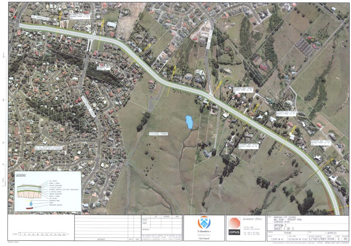
MILL ROAD CORRIDOR STUDY – ASSESSMENT OF ECOLOGICAL EFFECTS
36
Option C
© Kessels & Associates Ltd
DRAFT I 280708

MILL ROAD CORRIDOR STUDY – ASSESSMENT OF ECOLOGICAL EFFECTS
37
© Kessels & Associates Ltd
DRAFT I 280708
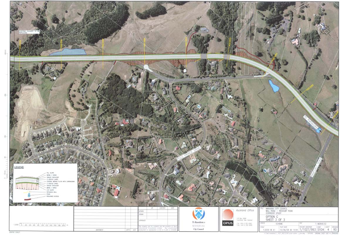
MILL ROAD CORRIDOR STUDY – ASSESSMENT OF ECOLOGICAL EFFECTS
38
© Kessels & Associates Ltd
DRAFT I 280708
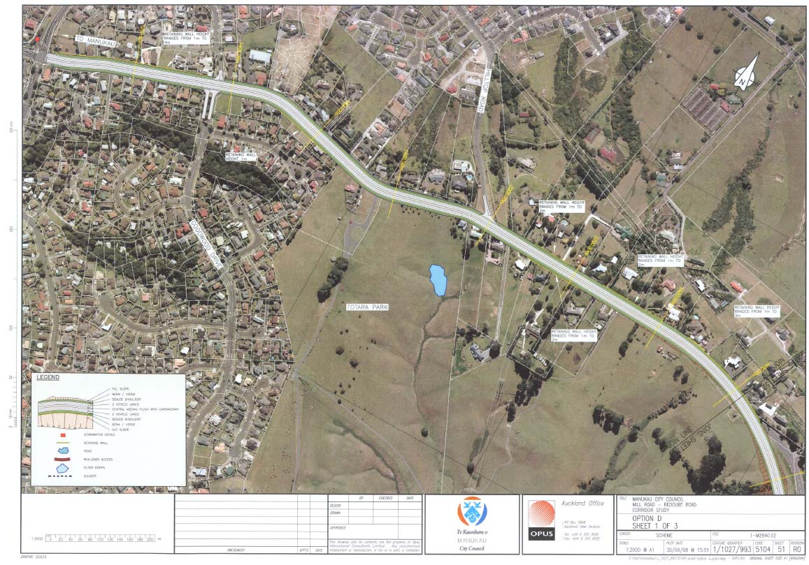
MILL ROAD CORRIDOR STUDY – ASSESSMENT OF ECOLOGICAL EFFECTS
39
Option D
© Kessels & Associates Ltd
DRAFT I 280708
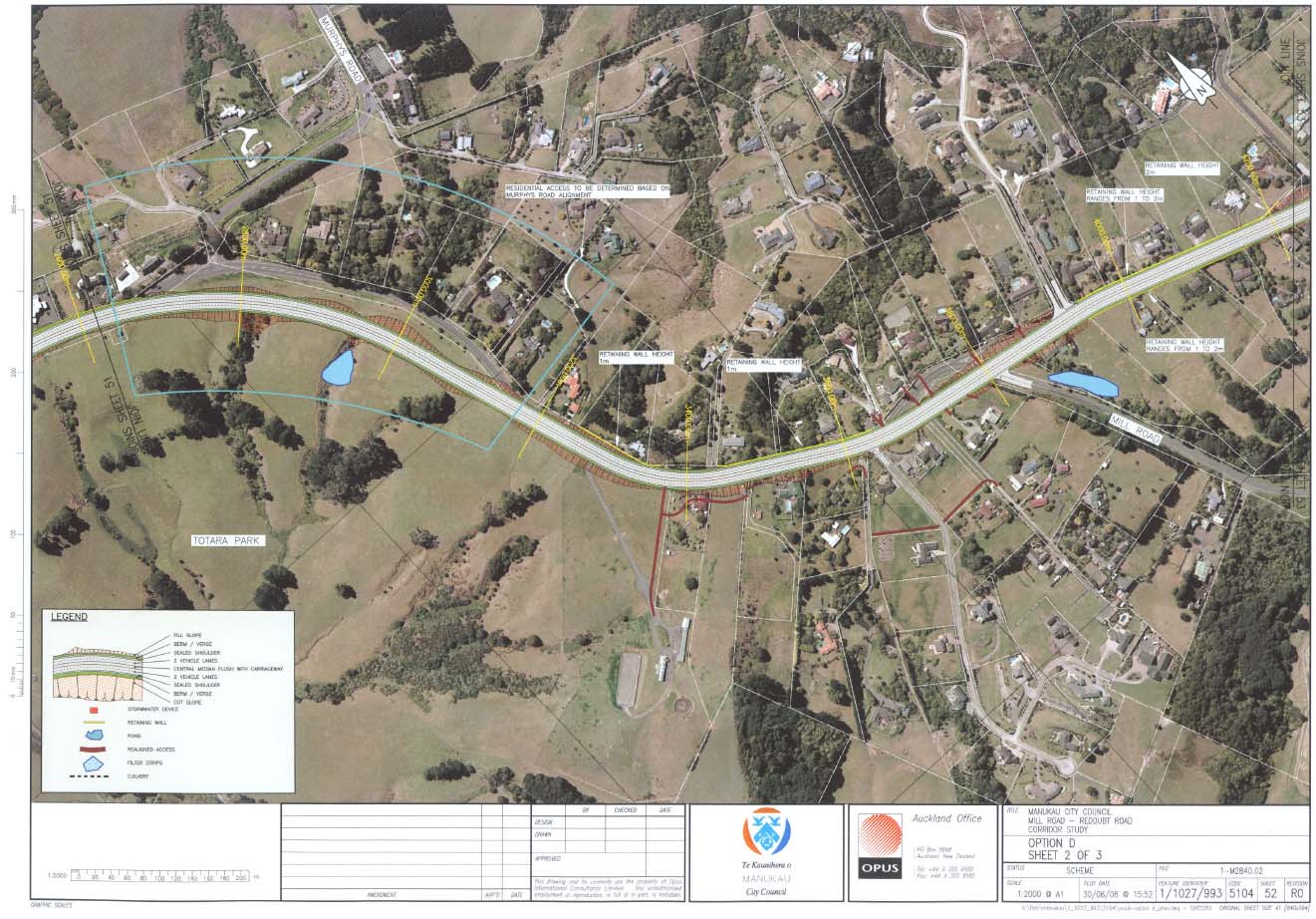
MILL ROAD CORRIDOR STUDY – ASSESSMENT OF ECOLOGICAL EFFECTS
40
© Kessels & Associates Ltd
DRAFT I 280708
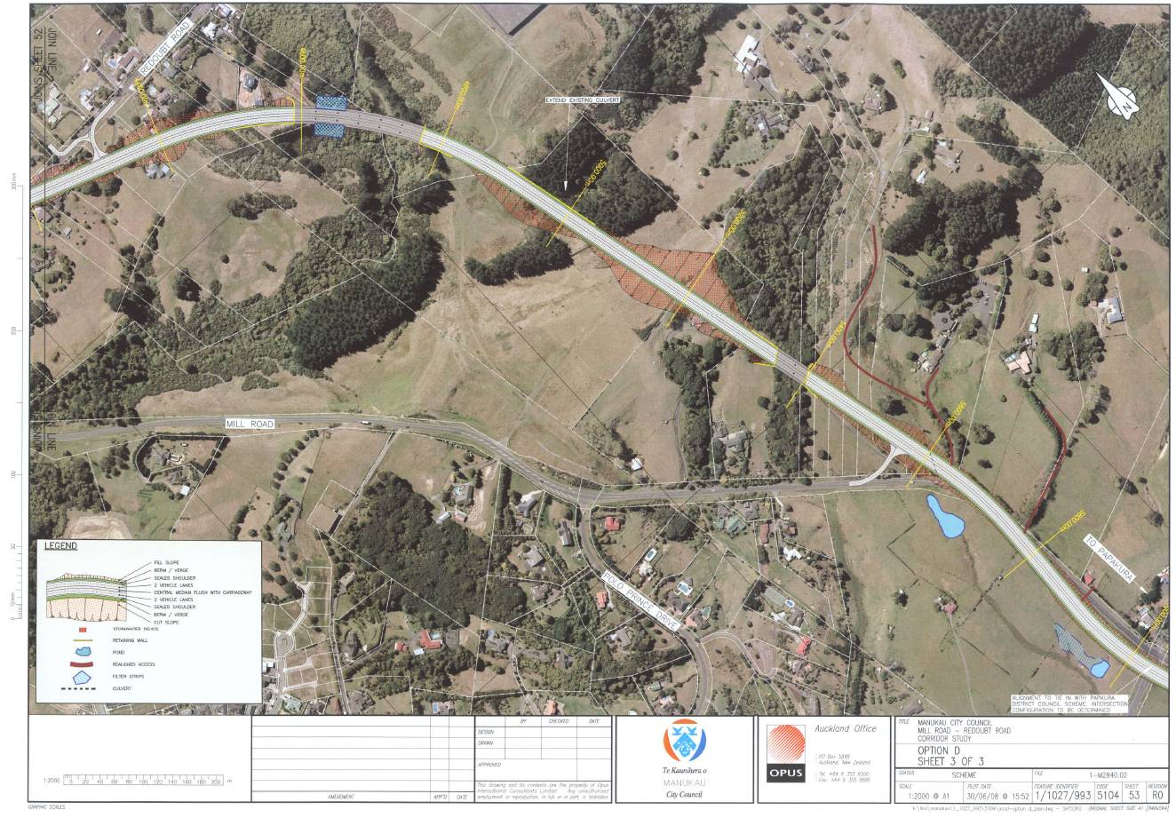
MILL ROAD CORRIDOR STUDY – ASSESSMENT OF ECOLOGICAL EFFECTS
41
© Kessels & Associates Ltd
DRAFT I 280708
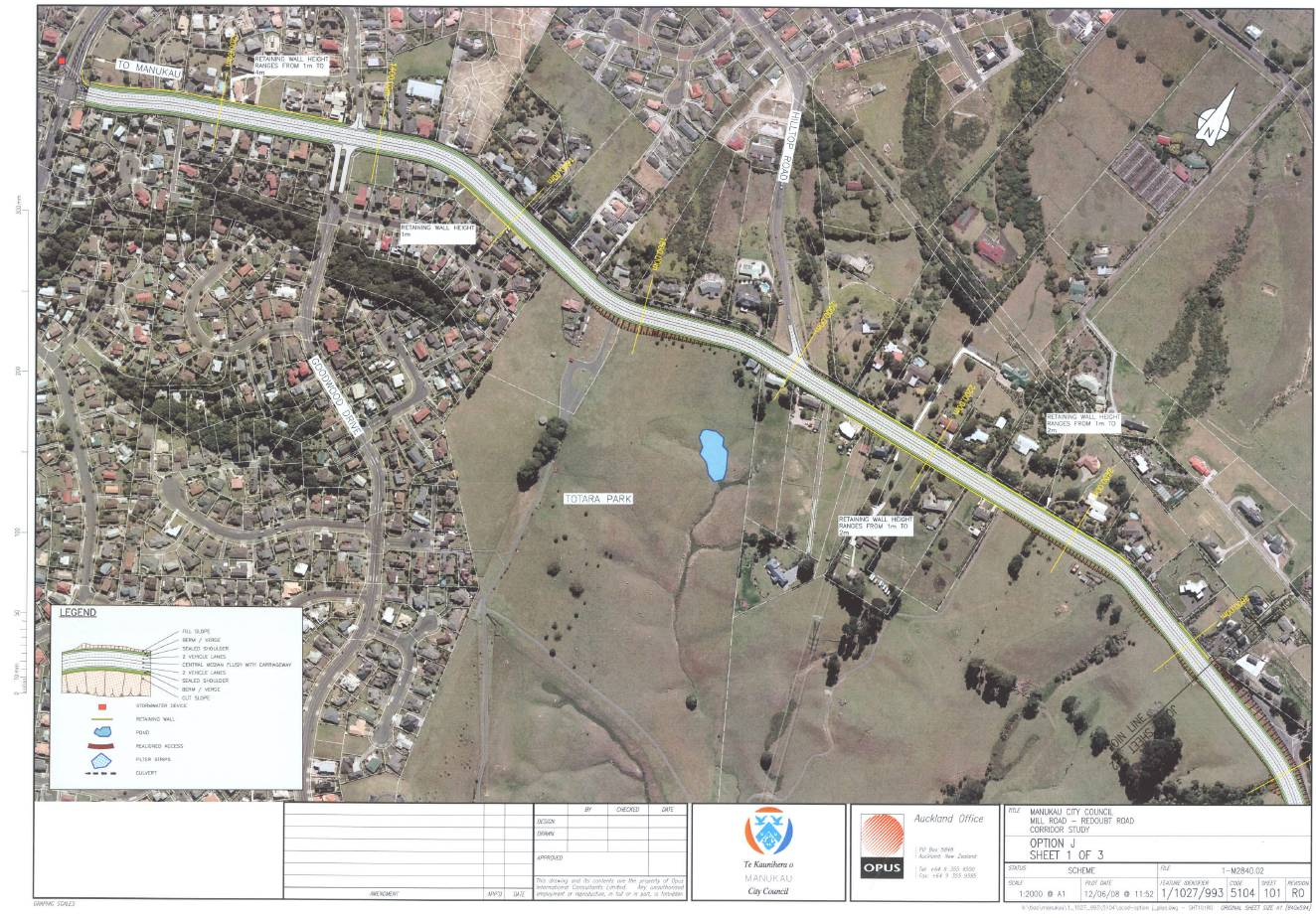
MILL ROAD CORRIDOR STUDY – ASSESSMENT OF ECOLOGICAL EFFECTS
42
Option J
© Kessels & Associates Ltd
DRAFT I 280708
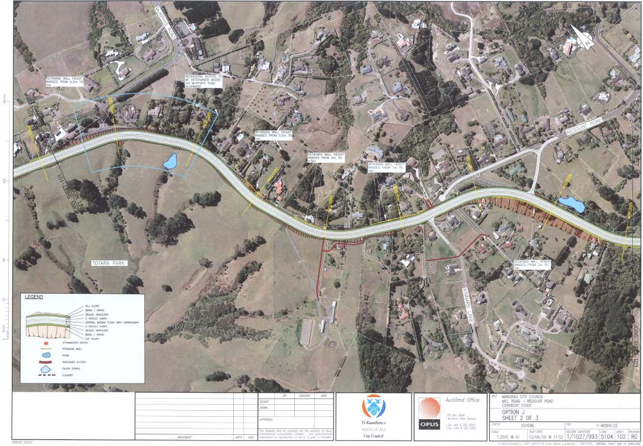
MILL ROAD CORRIDOR STUDY – ASSESSMENT OF ECOLOGICAL EFFECTS
43
© Kessels & Associates Ltd
DRAFT I 280708
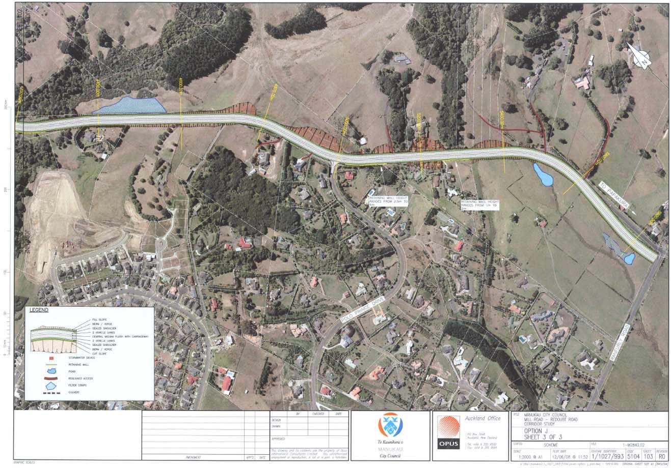
MILL ROAD CORRIDOR STUDY – ASSESSMENT OF ECOLOGICAL EFFECTS
44
© Kessels & Associates Ltd
DRAFT I 280708
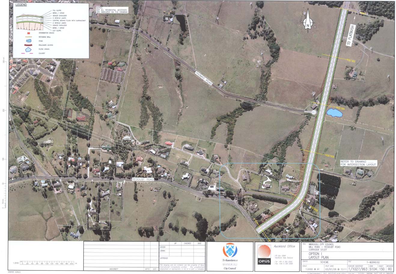
MILL ROAD CORRIDOR STUDY – ASSESSMENT OF ECOLOGICAL EFFECTS
45
Option I
© Kessels & Associates Ltd
DRAFT I 280708
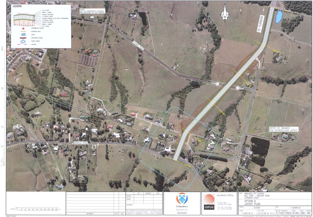
MILL ROAD CORRIDOR STUDY – ASSESSMENT OF ECOLOGICAL EFFECTS
46
Option K
© Kessels & Associates Ltd
DRAFT I 280708
MILL ROAD CORRIDOR STUDY – ASSESSMENT OF ECOLOGICAL EFFECTS
47
Appendix II
Flora Species List
© Kessels & Associates Ltd
DRAFT I 280708
MILL ROAD CORRIDOR STUDY – ASSESSMENT OF ECOLOGICAL EFFECTS
48
Flora Species List
Compiled by Britta Deichmann & Gerry Kessels 14 July 2008
Indigenous species:
Acianthus
sinclairii
heart-leaved orchid
Agathis
australis
kauri
Alectryon
excelsa
titoki
Asplenium
flaccidum
hanging spleenwort
Asplenium oblongifolium
shining spleenwort
Asplenium
polyodon
sickle spleenwort
Beilschmiedia taraire
taraire
Beilschmiedia
tawa
tawa
Blechnum
filiforme
thread fern
Blechnum novae-zelandiae
kiokio
Brachyglottis repanda
rangiora
Carex geminata
Carex
secta
pukio
Carex sp.
Carpodetus
serratus
putaputaweta
Collospermum hastatum
kahakaha
Coprosma grandifolia
kanono
Coprosma rhamnoides
twiggy coprosma
Coprosma
robusta
karamu
Coprosma spathulata
coprosma
Cordyline
australis
cabbage tree
cf. Corokia cotoneaster
korokio
Cortaderia
fulvida
toetoe
Corynocarpus laevigatus
karaka
Cyathea cunninghamii
gully tree fern
Cyathea
dealbata
ponga
Cyathea
medullaris
mamaku
Dacrydium cupressinum
rimu
Dacrydium dacrydioides
kahikatea
Dicksonia
squarrosa
wheki
Doodia
media
rasp fern
Dysoxylum spectabile
kohekohe
Earina
mucronata
bamboo orchid
Freycinetia
banksii
kiekie
Geniostoma rupestre var.
ligustrifolium
hangehange
Haloragis
erecta
shrubby haloragis
Hedycarya
arborea
pigeonwood
Histiopteris
incisa
water fern
© Kessels & Associates Ltd
DRAFT I 280708
MILL ROAD CORRIDOR STUDY – ASSESSMENT OF ECOLOGICAL EFFECTS
49
Hoheria
sextylosa
lacebark
Hymenophyllum
sp.
filmy fern
Knightia
excelsa
rewarewa
Kunzea
ericoides
kanuka
Lastreopsis microsora
Laurelia novaezelandiae
pukatea
Leptospermum scoparium
manuka
Leucopogon fasciculatus
mingimingi
Litsea
calicaris mangeao
Macropiper
excelsa
kawakawa
Melicytus
ramiflorus
mahoe
Metrosideros
diffusa
climbing rata
Metrosideros fulgens
climbing rata
Metrosideros perforata
white rata
Microsorum pustulatum
hound’s tongue fern
Microsorum scandens
fragrant fern
Muehlenbeckia australis
pohuehue
Myrsine
australis
mapou
Nertera
villosa nertera
Oplismenus
hirtellus
bamboo grass
Paesia
scaberula
ring fern
Passiflora
tetrandra
NZ passionfruit
Parsonsia heterophylla
New Zealand jasmine
Phormium
tenax
flax
Phyllocladus trichomanoides
tanekaha
Pittosporum
ssp.
pittosporum
Pneumatopteris pennigera
gully fern
Podocarpus
totara
totara
Pratia angulata pratia
Prumnopitys
taxifolia
matai
Pseudopanax arboreus
five-finger
Pseudopanax crassifolius
lancewood
Pteris
macilenta
sweet fern
Pyrrosia
eleagnifolia
leather-leaf fern
Rhopalostylis
sapida
nikau
Schefflera
digitata
pate
Tsmesipteris lanceolata
fork fern
Typha
orientalis
raupo
Uncinia
uncinata
hookgrass
Vitex
lucens
puriri
© Kessels & Associates Ltd
DRAFT I 280708
MILL ROAD CORRIDOR STUDY – ASSESSMENT OF ECOLOGICAL EFFECTS
50
Adventive species:
Acacia
sp.
wattle
Agapanthus praecox subsp. orientalis
agapanthus
Alocasia brisbanensis elephant’s
ear
Anthoxanthum odoratum
sweet vernal
Araujia
sericifera
moth plant
Aster novi-belgii
Michelmas
daisy
Bellis
perennis bellis daisy
Berberis glaucocarpa
barberry
Calystegia silvatica subsp. disjuncta great
bindweed
Cirsium
arvense
Californian thistle
Cirsium
vulgare
Scotch thistle
Cortaderia
selloana
pampas
Crocosmia x crocosmiiflora
montbretia
Cupressus macrocarpa
macrocarpa
Cyperus sp.
Dactylis
glomerata
cocksfoot
Hedychium flavescens
yellow
ginger
Hedychium gardnerianum
wild
ginger
Holcus
lanatus Yorkshire fog
Juncus
effusus leafless rush
Leycesteria formosa
Himalayan honeysuckle
Ligustrum
lucidum
tree privet
Ligustrum
sinense
Chinese privet
Lonicera
japonica
Japanese honeysuckle
Lotus
pedunculatus
lotus
Mentha
sp.
mint
Pennisetum clandestinum
Kikuyu
grass
Persicaria hydropiper
water pepper
Phytolacca
octandra
inkweed
Pinus
radiata
radiata pine
Plantago
lanceolata
narrow-leaved plantain
Plantago
major broad-leaved plantain
Populus
sp.
poplar
Ranunculus repens
creeping
buttercup
Rubus fruticosus agg.
blackberry
Senecio
jacobaea
ragwort
Solanum mauritianum
woolly nightshade
Solanum
nigrum
black nightshade
Stachys
sylvatica
hedge woundwort
Stellaria
media chickweed
© Kessels & Associates Ltd
DRAFT I 280708
MILL ROAD CORRIDOR STUDY – ASSESSMENT OF ECOLOGICAL EFFECTS
51
Taraxacum
officinale
dandelion
Tradescantia fluminensis
wandering Jew
Trifolium repens
white
clover
Tropaeolum
majus
garden nasturtium
Ulex
europaeus
gorse
Vinca
major
periwinkle
Zantedeschia aethiopica
Arum lily
© Kessels & Associates Ltd
DRAFT I 280708
MILL ROAD CORRIDOR STUDY – ASSESSMENT OF ECOLOGICAL EFFECTS
52
Appendix III
Bat Monitoring Methodology
© Kessels & Associates Ltd
DRAFT I 280708
MILL ROAD CORRIDOR STUDY – ASSESSMENT OF ECOLOGICAL EFFECTS
53
Bat Monitoring Methodology
Prepared by Kessels & Associates Ltd
Survey of the proposed Mill Road / Redoubt Road corridor area for the presence and distribution of
bats, their use of the area and where possible locate roost trees using ultrasound monitoring to
establish baseline bat activity.
Bat Presence and Distribution Survey Methods
Presence and an estimation of the distribution of bats throughout the proposed Mill Road / Redoubt
Road corridor can be assessed using ultrasound detection methods. Such methods can provide
baseline information about bat activity in an area of interest, although the information is non-
quantitative and cannot be related to population size or be used to accurately determine foraging or
roosting sites. However, it can provide the basis for more detailed monitoring methods by identifying
areas of concentrated bat activity, which can be used as capture sites. Further, ultrasound monitoring
is a useful tool for determining natural seasonal fluctuations in bat activity.
As bats have been recorded to use forest edges as flyways (Law & Chidel, 2002), a transect will be
designated along the edge of each of the forest patches and for any other significant habitats. Each
transect will follow paths or corridors along the entire length of each forest edge nearest to the
proposed corridor area or circumnavigating any forest patch that is entirely within the corridor. The
exact path of each transect will be determined by experienced bat researchers to allow for easy access
to and passage along transects, while also maximizing the potential to detect bats.
A team of two observers should conduct the transect surveys by walking slowly (approximately 3 km
per hour) along transects and listening for the sound of bat echolocation calls with a heterodyne bat
detector set to 40 kHz (O’Donnell & Sedgeley, 1999). Observers should use standard map and
recording sheets on which to record the location of any bat passes (a series of sequential echolocation
calls separated by a period of silence), the number of bat passes, the time of each bat pass and the
number of any bats detected visually. In addition, observers should record cloud cover, temperature,
relative wind, and a subjective assessment of insect activity (recorded on a scale from zero to five). To
maximise the likelihood of detecting bats, surveys should be conducted during the bats’ most active
period, the first two hours after sunset (O’Donnell & Sedgeley, 1999). Because rain or very strong
winds may greatly reduce the likelihood of detection (O’Donnell & Sedgeley, 1999), surveys should be
conducted on clear nights with little or no wind.
In the first instance, 5 nights of ultrasound monitoring at each transect should be conducted between
peak activities (usually between December – January). This will provide a baseline for activity and
highlight areas where bats may be trapped in sufficient numbers.
References
Law, B. S. & Chidel, M. 2006. Eucalypt plantings on farms: Use by insectivorous bats in south-eastern
Australia.
Biological Conservation. 133(2) pp. 236-249
O'Donnell, C.F.J. & Sedgeley, J.A. 1999. Use of roosts by the long-tailed bat,
Chalinolobus
tuberculatus, in temperate rainforest in New Zealand.
Journal of Mammalogy, 80, pp. 913-923
© Kessels & Associates Ltd
DRAFT I 280708
MILL ROAD CORRIDOR STUDY – ASSESSMENT OF ECOLOGICAL EFFECTS
54
Appendix IV
Threatened Environments Classification Map
Manukau City
As described by Walker
et al. (2007)
© Kessels & Associates Ltd
DRAFT I 280708
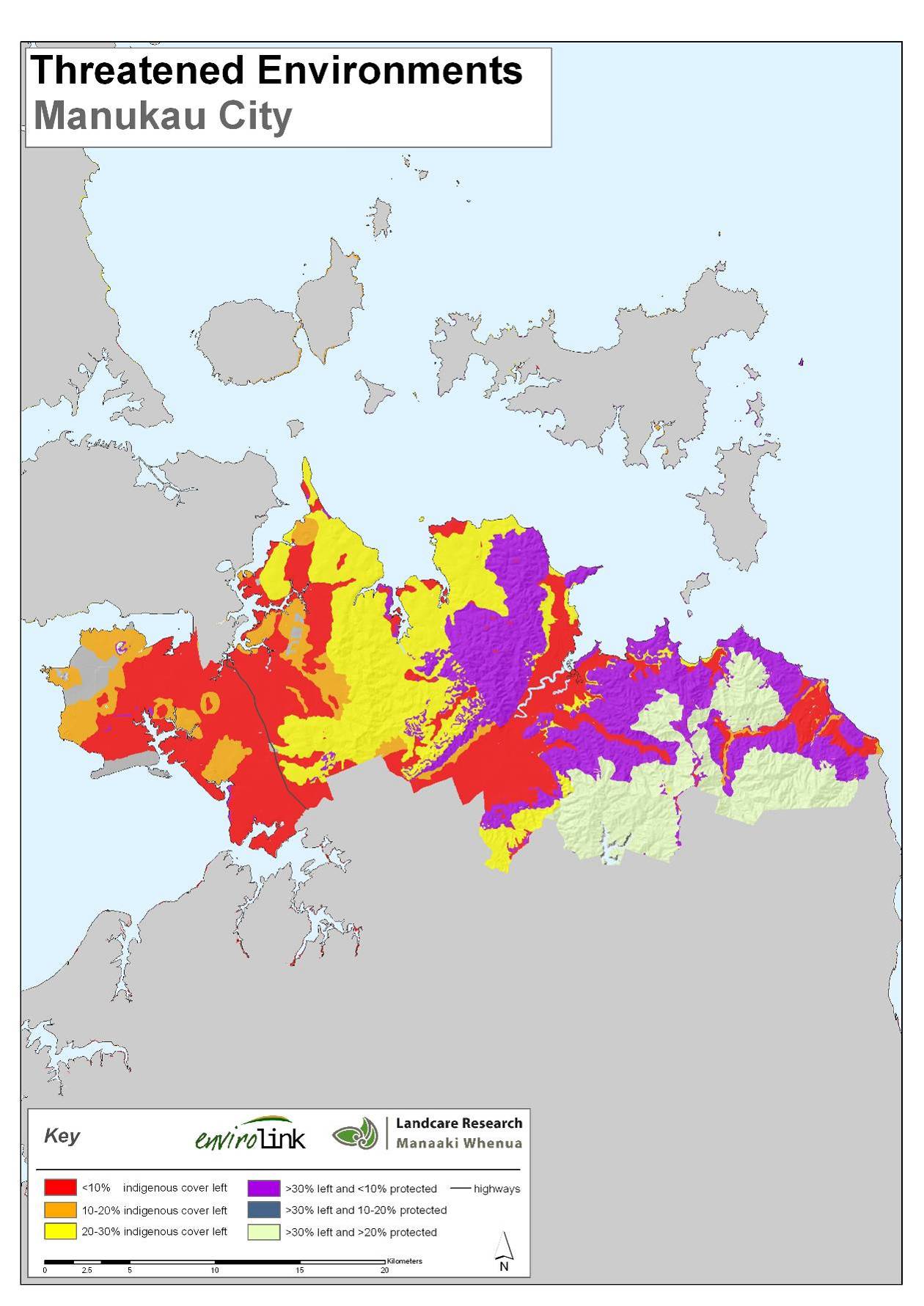
MILL ROAD CORRIDOR STUDY – ASSESSMENT OF ECOLOGICAL EFFECTS
55
© Kessels & Associates Ltd
DRAFT I 280708